
Warmest Air of the Year So Far in Central Florida – Mid and Upper Nineties by the Midweek
Warmest Air of the Year So Far in Central Florida – Mid and Upper Nineties by the Midweek
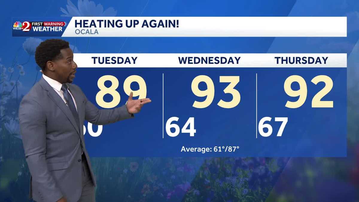
I’M JACKIE DEFUSCO. LET’S TALK ABOUT SOME GOOD NEWS RIGHT NOW. THE WEATHER. IT IS GORGEOUS OUT THERE. NICE AND COOL. AND IF YOU LIKE THOSE HOTTER TEMPERATURES AND YOU WANT TO GO OUT TO THE BEACH, THEN THIS IS THE WEEK YOU WANT THE GOOD NEWS OR THE BAD NEWS IN THE FORECAST. THERE’S BAD NEWS. NO, MARQUISE, YOU CAN’T DO THAT TO ME. EVERYTHING WAS LOOKING BEAUTIFUL, I WAS SMILING. YOU’RE SMILING. WELL, HERE’S THE THING. IT’S GOING TO BE GOOD NEWS FOR ME. MAYBE BAD NEWS FOR YOU. WE MIGHT GET A LITTLE BIT TOO HOT FOR COMFORT. TEMPERATURES SURGE INTO THE 90S ON THURSDAY. THE GOOD NEWS IS, WILL YOUR SUNGLASSES WILL DEFINITELY GET GOOD USAGE THIS WEEK. MONDAY THROUGH THURSDAY. NOTHING BUT SUNSHINE COMING YOUR WAY HERE IN CENTRAL FLORIDA, AS WE DO HAVE A SYSTEM OF HIGH PRESSURE KEEPING US NICE AND DRY. MAYBE NOT THE BEST NEWS FOR YOUR FRONT LAWN. IF YOU NEED THAT SOAKING OF RAIN COMING IN, WE WON’T GET THAT UNTIL FRIDAY. A 30% COVERAGE, BRINGING TEMPERATURES DOWN INTO THE MIDDLE OF THE 80S ALONG THE COAST. BUT INLAND WILL BE EVEN WARMER. ACTUALLY HIT THE 90S BY WEDNESDAY IN OCALA. AS WE START TO HEAT UP NICELY THROUGHOUT THE WORKWEEK. KEEP IN MIND YOUR SEASONAL AVERAGE HIGH THAT SITS RIGHT AROUND 87 DEGREES IN OCALA. HERE’S THAT HIGH PRESSURE SYSTEM THAT I WAS TALKING ABOUT. AND NOTICE HOW THE CLOUDS ARE FILTERING AWAY TOWARDS THE SOUTH AND THE EAST AS THIS SLIDES INTO THE PICTURE. THAT IS WHAT’S GOING TO KEEP US NICE AND SUNNY THROUGHOUT THE WORKWEEK. IN FACT, WE’RE STILL HOLDING ON TO THAT SUNSHINE RIGHT NOW. PARTLY CLOUDY SKIES, WINDS FROM THE EAST AT TEN MILES PER HOUR HAVE TEMPERATURES IN THE MID 70S. SO WE DID EXPERIENCE A LITTLE BIT OF A COOLDOWN TO FINISH OFF YOUR WEEKEND. AND THAT COOLDOWN TAKES TEMPERATURES INTO THE 50S TO START OFF YOUR WORKWEEK. BRIGHT SUNSHINE IS BACK AS WE KICK OFF YOUR MONDAY MORNING WITH 54 DEGREES OVERNIGHT LOWS IN OCALA, 59 IN THE VILLAGES, BUT THE FURTHER EAST YOU GO, THE WARMER TEMPERATURES ARE GOING TO BE TO START OFF THE DAY. AND THAT’S TYPICAL FOR OUR COASTAL COMMUNITIES IN PALM BAY, MELBOURNE AND BREVARD COUNTY WILL BE IN THE MID TO UPPER 60S AND LOW 70S. STILL, THOUGH, WE’RE MONITORING A FIRE DANGER THREAT ENTERING THE WORKWEEK, DRY CONDITIONS AND BREEZY WINDS, USUALLY A RECIPE FOR FIRES TO SPREAD IF WE HAVE ANY OUTDOOR BURNS THAT HAPPEN TO BECOME A LITTLE BIT TOO LARGE. SO JUST REMEMBER TO KEEP THE OUTDOOR BURNING TO A MINIMUM AS THE FIRE DANGER THREAT IS HIGH, BUT THE FORECAST IS ALSO LOOKING PRETTY GREAT THROUGHOUT YOUR WORKWEEK. IN FACT, AS TEMPERATURES RISE, IT’S ONLY GOING TO GET BETTER AND BETTER. IT’S THE RETURN OF THE 80S. TOMORROW IN THE AFTERNOON, ACROSS THE BEACHES. WELL, OUR RIP CURRENT RISK IS GOING TO BE MODERATE. THAT WILL ELEVATE AS THE WORKWEEK DOES PROGRESS WITH THIS SYSTEM OF HIGH PRESSURE SWINGING OFF TOWARDS THE EAST, WE’LL HAVE MORE OF A SOUTH AND EASTERLY FLOW WEDNESDAY INTO THURSDAY, AND THAT’S SLAMMING UP AGAINST THE COASTLINE WILL INCREASE THAT RIP CURRENT RISK. BUT IT’S ALSO INCREASING TEMPERATURES SO FAR IN ORLANDO, WE’VE SEEN FOUR DAYS THIS YEAR WITH TEMPERATURES HAVE PUSHED BEYOND 90 DEGREES. WE’LL CONTINUE TO ADD TO THAT TOTAL AS YOUR WORKWEEK DOES PROGRESS. SO HERE’S WHAT WE HAVE COMING YOUR WAY. WE’RE BACK IN THE UPPER 80S BY TUESDAY, LOW 90S. BY WEDNESDAY, WE COULD HAVE THREE CONSECUTIVE. IF NOT MAYBE FOUR CONSECUTIVE DAYS WITH HIGHS IN THE 90S FOR WEDNESDAY THROUGH FRIDAY COMING REALLY CLOSE. SATURDAY AND SUNDAY. WE’LL
Warmest Air of the Year So Far in Central Florida – Mid and Upper Nineties by the Midweek
Warmest Air of the Year So Far in Central Florida – Mid and Upper Nineties by the Midweek

Updated: 6:39 PM EDT May 3, 2026
Warmest Air of the Year So Far in Central Florida – Mid and Upper Nineties by the MidweekCooler today – and even with clouds moving out, highs have only warmed into the upper 70s. There is a small chance for quick hitting isolated showers along the coast tonight, otherwise dry conditions will remain in place for the vast majority of us here in Central Florida. That dry pattern will follow us into the workweek, in which under consistent sunshine a new warming trend is just around the corner. In fact, it will come equipped with some of the warmest highs we’ve seen all season. Get ready for inland temps to surge into the low to mid-nineties by Wednesday and Thursday. That gradual warming trend will make for some excellent beach days as well with coastal highs in the upper eighties and low nineties. Just make sure to swim with a lifeguard close by and keep an eye on flag conditions. As moderate-high rip current threats will return to the picture by Tuesday.
Warmest Air of the Year So Far in Central Florida – Mid and Upper Nineties by the Midweek
Cooler today – and even with clouds moving out, highs have only warmed into the upper 70s. There is a small chance for quick hitting isolated showers along the coast tonight, otherwise dry conditions will remain in place for the vast majority of us here in Central Florida. That dry pattern will follow us into the workweek, in which under consistent sunshine a new warming trend is just around the corner. In fact, it will come equipped with some of the warmest highs we’ve seen all season. Get ready for inland temps to surge into the low to mid-nineties by Wednesday and Thursday. That gradual warming trend will make for some excellent beach days as well with coastal highs in the upper eighties and low nineties. Just make sure to swim with a lifeguard close by and keep an eye on flag conditions. As moderate-high rip current threats will return to the picture by Tuesday.