
TODAY: Near-record heat brings Central Florida’s hottest day of the year so far
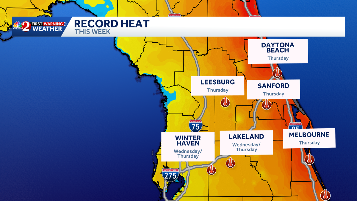
THEN YOU’VE GOT THE SPEEDWAY. THERE’S A LOT OF PAVEMENT AROUND THESE PLACES. SO LISTEN, IF YOU’RE HEADING OUT, ALL HONESTY, WE ALL LIKE TO HAVE AN ENJOYABLE ADULT BEVERAGE, BUT WE’VE GOT TO KEEP HYDRATED BECAUSE THIS IS THE KIND OF WEATHER THAT REALLY COULD GET US INTO TROUBLE. UPPER 80S OVER THERE. WELCOME TO ROCKVILLE AT THE SPEEDWAY. FRIDAY, SATURDAY AND SUNDAY WE WILL BE WATCHING FOR A FEW OPPORTUNITIES OF SHOWERS, EVEN A FEW THUNDERSHOWERS. SO JUST KEEP THAT IN MIND. LOOK AT THE SEVEN DAY FORECAST. ALL RIGHT. THIS IS THE WEEK, AT LEAST THIS YEAR THAT WE MAKE THAT CHANGE. AS MICHAEL KEEPING WITH THE MUSIC AS MICHAEL JACKSON SAID GOING INTO SUMMER 93 ON WEDNESDAY, 96 DEGREES ON THURSDAY, THEN WE START BUILDING IN THAT MOISTURE FOR FRIDAY, SATURDAY, SUNDAY WITH SHOWERS AND THUNDERSHOWERS. AND WE KEEP THOSE TEMPERATURES INTO THE LOWER 90S WITH THOSE DAILY STORMS. THAT SAID, TOMORROW IS GOING TO BE I MEAN, TODAY’S THE HOTTEST YET IN ORLANDO FOR THE YEAR AT 93, TOMORROW GETS EVEN HIGHER. THIS IS GOING TO BE THE HOTTEST TEMPERATURE THAT WE’RE GOING TO HAVE. RECORD HIGH IN ORLANDO IS 98. SO I DON’T EXPECT THAT. BUT IT’S GOING TO BE THE HOTTEST DAY SINCE MID AUGUST OF LAST YEAR. AND WHILE ORLANDO DOESN’T GET TO RECORD TEMPERATURES TOMORROW, EVERY OTHER SPOT IN CENTRAL FLORIDA DOES. SO IT’S DEFINITELY BIG HEAT. WE’RE BUILDING IN THE HEAT BECAUSE HIGH PRESSURE IS OVER TOP OF US. BUT I AM WATCHING THIS COLD FRONT THAT WHILE IT DOESN’T CLEAR OUR AREA AND COOL US DOWN, IT DOES HELP TO ENTER US INTO THAT SUMMER AFTERNOON AND THUNDERSTORM TYPE PATTERN. SO PAUSING ON FRIDAY AFTERNOON, OUR LONG RANGE FUTURECAST SHOWING SHOWERS IN THE METRO AREA. SATURDAY MORNING’S FINE SATURDAY AFTERNOON. TRYING TO FOCUS SOME RAINS OVER ON THE EAST COAST ZONES. AND THEN SUNDAY AFTERNOON FOCUSING RAINS ON THE EAST COAST ZONES. BUT THERE’S STORMY WEATHER UP TO THE NORTH, SO IT DOES NOT LOOK LIKE A WASHOUT OF A WEEKEND. BUT IT DOES LOOK LIKE WE’RE STARTING TO ENTER INTO THAT AFTERNOON STORM REGIME OUTSIDE WE GO THIS MORNING. IT IS LOVELY. PORT CANAVERAL, JUST A LITTLE BIT OF CLOUD COVER OVER TOP. THE REST OF CENTRAL FLORIDA LOOKING GREAT. READINGS ARE IN THE 60S. IT FEELS GREAT, BUT THERE IS A HINT AT ADDITIONAL HUMIDITY. AND IF YOU HAVEN’T STEPPED OUT THE DOOR, YOU’LL FEEL IT FOR SURE. 93 THIS AFTERNOON IN ORLANDO, 96 IN THE VILLAGES, 95 IN OCALA. IT IS GOING TO BE VERY HOT. IF YOU’RE HEADING OVER TO THE BEACH TODAY. SURF BREAKING 1 TO 2 WATER TEMPERATURES MID TO UPPER 70. SO WE’RE ABSOLUTELY FEELING MORE AND MORE LIKE SUMMER AND AIR TEMPERATURES IN THE LOWER 80S ON THE BEACH SAND CERTAINLY WARMER. YOU STEP A COUPLE OF STEPS INLAND SO IT GETS SUMMER HEAT THESE NEXT COUPLE OF DAYS.
TODAY: Near-record heat brings Central Florida’s hottest day of the year so far

Updated: 7:13 AM EDT May 6, 2026
Central Florida is starting off comfortably on Wednesday morning, but a surge of summer heat is building fast by the afternoon.High temperatures are expected to climb to around 93 degrees today, making it the hottest day so far this year. The heat will ramp up further on Thursday, with highs near 96 degrees in some areas. Relief is on the way on Friday as scattered afternoon storms are expected to develop.This will slightly lower temperatures while bringing in a more typical summer pattern of heat and daily rain chances.First Warning Weather Stay with WESH 2 online and on-air for the most accurate Central Florida weather forecast.RadarSevere Weather AlertsDownload the WESH 2 News app to get the most up-to-date weather alerts. The First Warning Weather team includes First Warning Chief Meteorologist Tony Mainolfi, Eric Burris, Marquise Meda, Cam Tran and Victoria Wisniewski.
ORLANDO, Fla. —
Central Florida is starting off comfortably on Wednesday morning, but a surge of summer heat is building fast by the afternoon.
High temperatures are expected to climb to around 93 degrees today, making it the hottest day so far this year.
The heat will ramp up further on Thursday, with highs near 96 degrees in some areas.
This content is imported from Twitter.
You may be able to find the same content in another format, or you may be able to find more information, at their web site.
Relief is on the way on Friday as scattered afternoon storms are expected to develop.
This will slightly lower temperatures while bringing in a more typical summer pattern of heat and daily rain chances.
First Warning Weather
Stay with WESH 2 online and on-air for the most accurate Central Florida weather forecast.
Download the WESH 2 News app to get the most up-to-date weather alerts.
The First Warning Weather team includes First Warning Chief Meteorologist Tony Mainolfi, Eric Burris, Marquise Meda, Cam Tran and Victoria Wisniewski.