
Record heat grips Central Florida Thursday
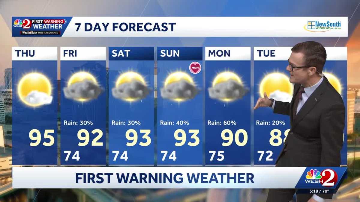
OUT. NOT TO SAY THAT THAT’S HARD OR ANYTHING FORECAST FOR US TODAY. LOOKING WONDERFUL. PARTLY CLOUDY SKIES. WE’RE MAKING IT INTO THE MID RANGE OF THE 90S. NOTICE THOUGH OUR TEMPERATURES COME DOWN JUST A LITTLE BIT. FRIDAY, SATURDAY, SUNDAY BECAUSE WE START TO ADD IN SHOWER, THUNDERSTORM OPPORTUNITIES. NOT A TON BUT A LITTLE BIT HERE OR THERE. THE NEXT COUPLE OF DAYS, KIND OF MORE AND MORE ON SETTING THAT NORMAL SUMMER PATTERN. SO LET’S DO THIS. LET’S TAKE OUR LONG RANGE FUTURECAST MODEL. THIS IS GOING TO BE 10:00 TOMORROW. STARTING TO SEE A FEW AREAS OF SHOWERS. THEN LET’S CONTINUE THIS THROUGH SATURDAY, 9 A.M. WE’RE LOOKING PRETTY OKAY, BUT IT’S INTO THE AFTERNOON. THERE’S 6 P.M. SHOWERS, EVEN A FEW THUNDER SHOWERS IN OUR AREA. THEN WE LOOK AHEAD TO SUNDAY. A WEAK FRONT TO THE NORTH. 7 A.M. WE’RE GOOD, BUT IT’S INTO THE AFTERNOON THAT WE POPCORN UP THOSE THUNDERSTORMS, KIND OF OFF TO THE SOUTH AND THEN INTO MONDAY. IT LOOKS LIKE RAIN CHANCES CONTINUE TO RISE. SO BASICALLY JUST OPPORTUNITIES FOR RAINFALL, WHICH MEANS WE HAVE TO REALLY TIME THINGS OUT. MOTHER’S DAY THIS IS THE BIG ONE FOR THE WEEKEND. BREAKFAST IN BED, LOOKING GREAT. HINT, HINT 89 DEGREES FOR LUNCH TIME. FEELING LIKE SUMMER, NO DOUBT ABOUT IT. AND THEN WE HAVE TO WATCH THE WESH TWO MOBILE APP IN THE AFTERNOON AS SHOWERS AND THUNDERSHOWERS GET GOING. MAYBE YOU’RE HEADING OVER TO THE BEACH THIS WEEKEND. TEMPERATURES ON THE SAND IN THE LOWER 80S IS GOING TO BE MUCH WARMER, LIKE A MILE INLAND, BUT WE’VE GOT TO POINT THAT OUT. SURF RUNNING ABOUT 1 TO 2 WATER TEMPERATURES IN THE MID TO UPPER 70S. SO GREAT. BEACH WEEKEND SHOULD BE A RELATIVELY LOW RISK OF RIP CURRENTS. IF YOU’RE HEADING OUT TO THE WELCOME TO ROCKVILLE FESTIVAL OVER AT THE DAYTONA INTERNATIONAL SPEEDWAY, IT LOOKS GREAT, ESPECIALLY FRIDAY. SATURDAY, THOUGH WE HAVE TO WATCH FOR THOSE AFTERNOON THUNDERSHOWERS. IT LOOKS LIKE SUNDAY THAT WILL TRY TO TAPER OFF JUST A LITTLE BIT. SO WHY ARE WE ON SETTING THIS RAINY PATTERN? WELL, THERE’S A LOT OF MOISTURE FROM MISSISSIPPI TO ALABAMA TO GEORGIA. THAT’S AN OLD FRONT THAT IS GRADUALLY MOVING SOUTH TODAY FROM PENSACOLA TO TALLAHASSEE, A LEVEL TWO OUT OF FIVE RISK FOR STRONG TO SEVERE STORMS. THERE’S A TORNADO WATCH UP THAT DIRECTION. BUT THAT MOISTURE AS IT FADES GRADUALLY WORKS OUR DIRECTION AND KIND OF HELPS TO ONSET THAT OPPORTUNITY. SO WHILE WE’RE DRY TODAY, THAT REMNANT MOISTURE STARTS BRINGING UP THE RAIN CHANCES THE NEXT COUPLE OF DAYS. THIS MORNING, LOOKING LOVELY ON OUR TOWER CAM NETWORK ALL ACROSS CENTRAL FLORIDA. IT’S GOING TO BE A BEAUTIFUL BUT HOT DAY. 95 OUR FORECAST HIGH TEMPERATURE FOR TOMORROW. WE START WITH TH
It’s starting to feel a lot like summer across Central Florida as temperatures continue climbing during a stretch of intense heat. After reaching 92 degrees on Wednesday, temperatures are expected to soar to around 95 degrees on Thursday, making for a hot stretch across the region.Most reporting stations — except Orlando — are expected to tie or break daily heat records, with some records dating back to the 1950s.Temperatures will not be quite as hot on Friday, with highs expected near 92 degrees. The slight drop comes as afternoon storms return to the forecast.First Warning Weather Stay with WESH 2 online and on-air for the most accurate Central Florida weather forecast.RadarSevere Weather AlertsDownload the WESH 2 News app to get the most up-to-date weather alerts. The First Warning Weather team includes First Warning Chief Meteorologist Tony Mainolfi, Eric Burris, Marquise Meda, Cam Tran and Victoria Wisniewski.
ORLANDO, Fla. —
It’s starting to feel a lot like summer across Central Florida as temperatures continue climbing during a stretch of intense heat.
After reaching 92 degrees on Wednesday, temperatures are expected to soar to around 95 degrees on Thursday, making for a hot stretch across the region.
Most reporting stations — except Orlando — are expected to tie or break daily heat records, with some records dating back to the 1950s.
Temperatures will not be quite as hot on Friday, with highs expected near 92 degrees. The slight drop comes as afternoon storms return to the forecast.
First Warning Weather
Stay with WESH 2 online and on-air for the most accurate Central Florida weather forecast.
Download the WESH 2 News app to get the most up-to-date weather alerts.
The First Warning Weather team includes First Warning Chief Meteorologist Tony Mainolfi, Eric Burris, Marquise Meda, Cam Tran and Victoria Wisniewski.