
Weather Update for the Florida Panhandle
A stretch of active weather is expected through the weekend, with several rounds of showers and thunderstorms moving across the region. Some storms could become strong to severe at times.
Severe Weather Risk Through the Weekend
A Level 1 out of 5 Marginal Risk for severe weather is in place this evening, mainly for the Florida Panhandle and Florida Big Bend.
Another Marginal Risk remains in effect for most of the area on Saturday and Sunday. The biggest concern with any stronger storms will be damaging wind gusts, although small hail cannot be ruled out.
Rain Chances Increasing
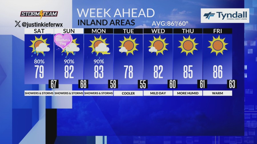
Periods of rain and thunderstorms are expected on and off through Monday. This rainfall will be beneficial for many areas.
The highest chances for at least 1 inch of rain, greater than 75 percent the western Florida Panhandle.
What Is Causing the Unsettled Weather?
A cold front that moved through yesterday has stalled near the Gulf waters and will remain nearby through the weekend. Several disturbances moving through the atmosphere will continue to trigger rounds of showers and storms.
As the front begins lifting north over the weekend, warmer and more humid air will spread back into the region. That setup will increase the potential for stronger thunderstorms Saturday and Sunday.
Timing of the Storms
This afternoon and evening: Storms will become more numerous across the Florida Panhandle and nearby areas.
Tonight: Showers and thunderstorms will spread across much of the region.
Saturday and Sunday: Multiple rounds of showers and storms are expected throughout the weekend.
Rain chances will be high for the western Florida Panhandle.
Temperatures
High temperatures this weekend will generally reach:
Upper 70s across Alabama and Georgia
Overnight lows will stay mild, mainly in the 60s.
Early Next Week
Another cold front is expected to move through on Monday, bringing one more round of showers and thunderstorms. It is still too early to determine how strong those storms may become, but conditions could support at least some severe weather potential.
By Tuesday, drier air will move in behind the front. Temperatures will briefly cool down before warming again later next week. Dry weather is expected for the second half of the week.
Marine Forecast
Boaters can expect generally light southerly winds through the weekend, with seas around 1 to 2 feet. However, scattered thunderstorms may create locally hazardous conditions at times.
A stronger cold front will move across the Gulf waters Monday night into Tuesday, bringing increasing northerly winds and building seas of 2 to 4 feet. Boating conditions may become hazardous, especially west of Apalachicola.
Copyright 2026 Nexstar Media, Inc. All rights reserved. This material may not be published, broadcast, rewritten, or redistributed.
For the latest news, weather, sports, and streaming video, head to mypanhandle.com.