
Impact Weather: Risk of damaging winds, hail as storms target parts of Central Florida
THEN YOU CAN SAVE A THOUSAND BUCKS. TAKE AN UMBRELLA. YEAH, I WOULD SAY SO. BECAUSE FUTURECAST POPCORN UP THOSE SHOWERS AND STORMS. I WANT TO SHOW YOU THOUGH. WHILE TODAY WE’VE GOT THE OPPORTUNITY FOR SOME STRONGER STORMS, WHICH IS WHY WE’RE CALLING FOR IMPACT WEATHER THIS AFTERNOON. TOMORROW, THE STORM COVERAGE ACTUALLY GOES UP. AND THEN WEDNESDAY, THURSDAY, FRIDAY, WE KIND OF DRY OUT JUST A LITTLE BIT BEFORE RESTARTING THE STORM MACHINE COME THIS WEEKEND. SO LET’S JUST TALK ABOUT TODAY. ALL RIGHT. WE’RE CALLING FOR IMPACT WEATHER, NOT JUST BECAUSE OF THE STORMS, BUT BECAUSE WE COULD SEE SOME STRONGER STORMS DEVELOPING ONCE AGAIN, WITH THE BIGGEST THREATS BEING KIND OF IN OUR EASTERN AREAS, JUST LIKE WHAT WE SAW YESTERDAY, THE TORNADO THREAT IS RELATIVELY LOW, BUT THE DAMAGING WIND AND HAIL THREAT AGAIN HIGHLIGHTS THE OPPORTUNITY TO SEE THAT. SO HERE’S FUTURECAST. I WANT TO TAKE YOU THROUGH TIME THROUGH TODAY. AND HERE’S 2:00. STARTING TO SEE SOME OF THESE AREAS OF RAIN POP. CORNING UP. WATCH OUT THROUGH 4:00. THE OVERALL COVERAGE STARTING TO INCREASE. AND THEN WE WORK ALL THAT RAIN OFF TOWARD THE EAST COAST. THERE’S DINNER TIME THROUGH ABOUT BEDTIME. SO THAT’S TODAY ON FUTURECAST. NOW LET’S FAST FORWARD AND LOOK AT TOMORROW ON FUTURECAST. WIDESPREAD SHOWERS AND THUNDERSHOWERS. LOOK AT DINNERTIME. IT’S ACTUALLY TRENDED UP A LITTLE BIT OVER WHAT WE’VE SEEN THE LAST COUPLE OF DAYS. SO THE REALITY IS TOMORROW LOOKS TO BE WET, BUT THE DYNAMICS DON’T LOOK TO BE THERE FOR ANYTHING STRONG. TOMORROW IS MORE OF A SHOWER AND THUNDERSTORM, BUT A LESS INTENSE DEAL OUTSIDE THIS MORNING. IT’S A QUIET START HERE IN OCALA. MARION COUNTY, 74 THERE AT 73 IN ORLANDO. THIS FEELS LIKE A SUMMER’S MORNING. LOW DOWN, FIRST WARNING LIVE RADAR SHOWING SOME REAL LIGHT STUFF WORKING ACROSS FLAGLER. MORE THAN LIKELY THAT’S NOT MAKING IT TO THE GROUND. IT’S MORE VIRGA. SO IT’S PRECIPITATION THAT DRIES UP IN THE ATMOSPHERE. BUT IT GOES TO SHOW JUST HOW MOIST THIS ATMOSPHERE IS. SO WHEN WE LOOK AT THE FORECAST TODAY, I THINK WE’RE GOING TO HAVE MORE STORMS IN THE FORECAST FOR SURE. FROM ABOUT 2 P.M. TO 8 P.M., THERE’S A 50% COVERAGE OF SHOWERS AND STORMS. THAT’S WHAT YOU NEED TO TAKE WITH YOU OUT THE DOOR, THE KNOWLEDGE THAT IT’S GOING TO STORM ON. MANY OF US TODAY, 90 DEGREES, OUR HIGH TEMPERATURE IN ORLANDO AND THE VILLAGES, 89 IN DELAND, 89 IN SANFORD, AND 87 DEGREES IN NEW SMYRNA BEACH METRO. OFF TO THE EAST IS WHERE WE HAVE THE HIGHEST COVERAGE OF RAIN. AND IF YOU LIVE IN BREVARD COUNTY, YOU’RE KIND OF THE BULL’S EYE FOR THE MAJORITY OF THE BIGGER THUNDERSTORMS TODAY. SO THERE’S A FRONT TO THE NORTH. THAT’S WHAT’S HELPING TO SCOOP UP ALL THE MOISTURE FOR US. AS THAT FRONT PUSHES THROUGH, WE’RE GOING TO KEEP MOISTURE AROUND FOR TOMORROW AND EVEN INTO WEDNESDAY. BUT WEDNESDAY, THURSDAY, FRIDAY, WE DRY OUT JUST A LITTLE BIT AS THIS KIND OF SECONDARY FRONT PUSHES THROUGH. AND THAT’S WHY AT THIS POINT IN TIME, WE KNOW WE HAVE NOT YET STARTED THE RAINY SEASON BECAUSE FOR OUR THURSDAY, FRIDAY WE TURN DRIER. IT ONLY TAKES A COUPLE OF DAYS. THOSE STORMS RETURN BACK AND WE’RE BACK TO T
Impact Weather: Risk of damaging winds, hail as storms target parts of Central Florida

Updated: 7:53 AM EDT May 11, 2026
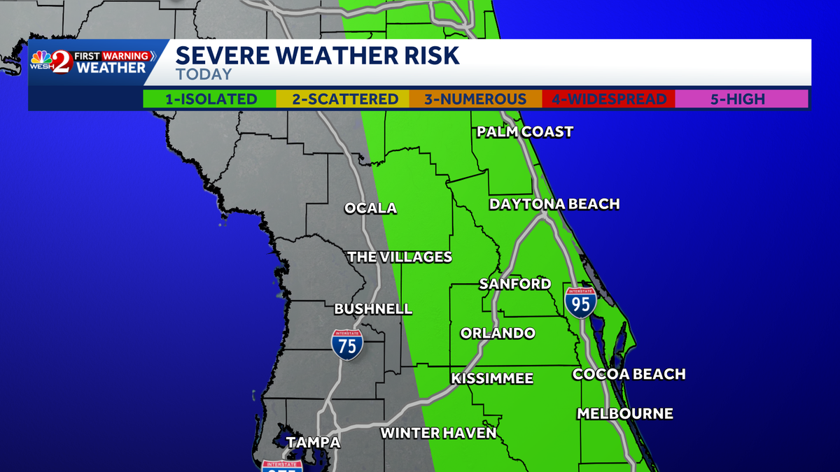
Strong to severe storms are expected to move across Central Florida on Monday. Warm and muggy conditions will start the day, with showers and storms expected in the afternoon and evening. Storm ImpactsThe area is under a Level 1 out of 5 risk for strong to severe storms, with hail and damaging wind gusts as the primary concerns. Tracking the TimingFor this reason, WESH 2’s First Warning Weather team has issued an Impact Weather Alert for Monday. The biggest threats are expected between 2 p.m. and 8 p.m.Temperatures are expected to reach around 90 degrees today.Once the storm system clears, conditions will dry out mid- to late week, then return over the weekend.What is Impact Weather?Impact Weather suggests weather conditions could be disruptive or a nuisance for travel and day-to-day activities.First Warning WeatherStay with WESH 2 online and on-air for the most accurate Central Florida weather forecast.RadarSevere Weather AlertsDownload the WESH 2 News app to get the most up-to-date weather alerts.The First Warning Weather team includes First Warning Chief Meteorologist Tony Mainolfi, Eric Burris, Marquise Meda, Cam Tran and Victoria Wisniewski.
ORLANDO, Fla. —
Strong to severe storms are expected to move across Central Florida on Monday.
Warm and muggy conditions will start the day, with showers and storms expected in the afternoon and evening.
This content is imported from Twitter.
You may be able to find the same content in another format, or you may be able to find more information, at their web site.
Storm Impacts
The area is under a Level 1 out of 5 risk for strong to severe storms, with hail and damaging wind gusts as the primary concerns.
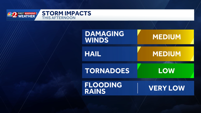
Tracking the Timing
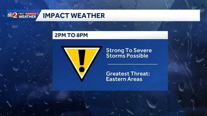
For this reason, WESH 2’s First Warning Weather team has issued an Impact Weather Alert for Monday. The biggest threats are expected between 2 p.m. and 8 p.m.
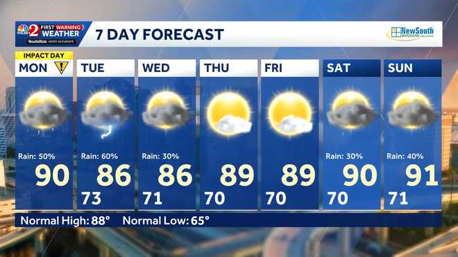
Temperatures are expected to reach around 90 degrees today.
Once the storm system clears, conditions will dry out mid- to late week, then return over the weekend.
What is Impact Weather?
Impact Weather suggests weather conditions could be disruptive or a nuisance for travel and day-to-day activities.
First Warning Weather
Stay with WESH 2 online and on-air for the most accurate Central Florida weather forecast.
Download the WESH 2 News app to get the most up-to-date weather alerts.
The First Warning Weather team includes First Warning Chief Meteorologist Tony Mainolfi, Eric Burris, Marquise Meda, Cam Tran and Victoria Wisniewski.