
Widespread rain expected Tuesday in Central Florida
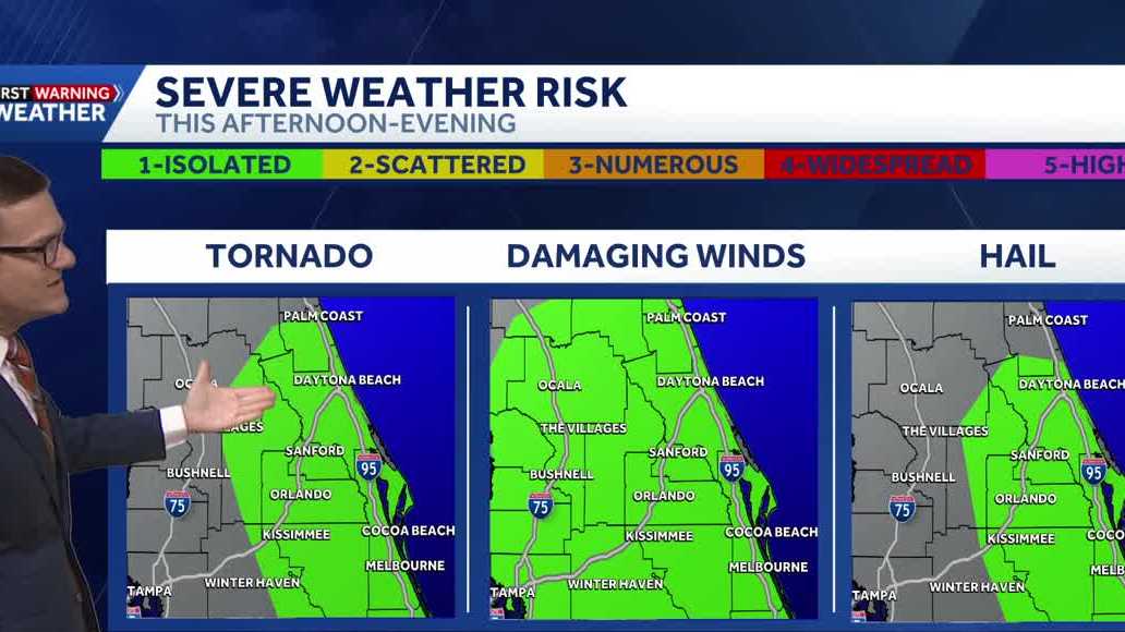
IT’S DEFINITELY GOING TO HELP US. THAT SAID THOUGH, IT’S STILL GOING TO BE IMPACTFUL. WIDESPREAD RAIN TODAY. THIS AFTERNOON, ALMOST ALL OF US ARE GOING TO GET IT. SO THAT’S WHY WE’RE CALLING FOR IMPACT WEATHER. AND THEN ADD TO THE FACT THAT WE COULD EVEN SEE AN ISOLATED, STRONG OR SEVERE STORM BUBBLE UP. WE DEFINITELY NEED TO WATCH THINGS NOW. BREAKING DOWN THE THREATS. HERE’S KIND OF THREAT BY THREAT WHERE THE TORNADO THREAT IS GOING TO BE THE METRO OFF TO THE EAST. ALMOST ALL OF US COULD SEE A WIND GUST PULSE UP, AND THE BIGGEST HAIL THREAT IS GOING TO BE THE METRO OFF TO THE EAST AS WELL. SO LET’S TIME THIS OUT HOUR BY HOUR. FUTURECAST. AND I’VE SLOWED FUTURECAST DOWN SO THAT WE CAN REALLY SEE THAT MOTION MINUTE BY MINUTE, HOUR BY HOUR, LUNCHTIME, STARTING WITH A FEW SHOWERS INTO VOLUSIA COUNTY. AND THEN LITTLE BY LITTLE, WE JUST SEE THE WORD INVIGORATE IS THE ONLY THING THAT COMES TO MIND. BUT THROUGH TWO 3:00, WE’VE GOT THE ENERGY IN PLAY. THE HEAT INVIGORATES THE ATMOSPHERE AND STARTS POPPING UP. THESE SHOWERS AND THUNDERSHOWERS. SO MANY OF THEM HEAVIER AT TIMES. THAT CONTINUES THROUGH THE METRO. NOW, I DO THINK OUR FUTURECAST IS A LITTLE HOT IN TERMS OF THE INTENSITY, BUT IT’S STILL SHOWING WIDESPREAD SHOWERS AND STORMS RIGHT IN THE METRO, RIGHT AT 5 P.M., SIX, 7:00. IT WORKS OVER TOWARD THE I-95 CORRIDOR. AND THEN IT EVEN LINGERS SOME RAIN. THERE’S 9:00 FLAGLER, VOLUSIA COUNTY CONTINUING THROUGH MIDNIGHT OR SO BEFORE PULLING ON OUT AND AWAY FROM US. SO OUT THE DOOR, YOU NEED TO KNOW IT’S WIDESPREAD STORMS, BASICALLY RAINING FROM 2 TO 11. 90% OF US ARE GOING TO GET WET, BUT I THINK 2 TO 8 IS THE WINDOW WHERE WE COULD SEE THE STRONGER STORMS DEVELOPING. NOW, THIS IS ALL BECAUSE THERE’S A DYING FRONT ESSENTIALLY OVER TOP OF US FOR TOMORROW. THAT FRONT STARTS TO PULL AWAY, TURNING OUR WINDS AROUND JUST A LITTLE BIT. AND WHILE WE DO HAVE SOME RAIN IN THE FORECAST, IT STARTS A DRYING TREND. AND THEN ANOTHER FRONT THAT’S DYING MOVES IN AND DRIES US OUT AND KEEPS US DRY FOR OUR FRIDAY AND EVEN INTO OUR SATURDAY. AND WITH THAT SAID, BECAUSE EVEN THOUGH IT’S NOT A COLD FRONT, IT’S STILL THROWS ENOUGH DRY AIR OUR DIRECTION. WE ARE NOT YET TO THE RAINY SEASON. THAT STORMY PATTERN ENDS EFFECTIVE LIKE TOMORROW AFTERNOON, EVENING, AND THEN WE GO DRY FOR A COUPLE OF DAYS. KIND OF RESETTING THAT TIME LINE OUTSIDE THIS MORNING. LOTS OF CLOUDS ON OUR TOWER CAM NETWORK. THE METRO IS NICE AND DRY, BUT THERE’S ALL THAT STORMY WEATHER FROM THE FRONT NORTH OF US. THAT’S ALL EVENTUALLY GOING TO BE MOVING OUR DIRECTION. SO A 90% COVERAGE OF RAIN FOR OUR TUESDAY. WE’LL KEEP A 50% COVERAGE OF SHOWERS AND STORMS IN TOMORROW AND THEN NOTICE THURSDAY, FRIDAY AND SATURDAY. MOST
Tuesday’s weather forecast includes widespread rain and the potential for a few isolated, stronger storms.For this reason, WESH 2’s First Warning Weather team is calling for Impact Weather. An earlier start to the rain will be a noticeable change from yesterday. The biggest threats are expected between 2 p.m. and 7 p.m. High temperatures are expected to be slightly lower due to clouds and rain.>> What is Impact Weather?Impact Weather suggests weather conditions could be disruptive or a nuisance for travel and day-to-day activities.First Warning Weather Stay with WESH 2 online and on-air for the most accurate Central Florida weather forecast.RadarSevere Weather AlertsDownload the WESH 2 News app to get the most up-to-date weather alerts. The First Warning Weather team includes First Warning Chief Meteorologist Tony Mainolfi, Eric Burris, Marquise Meda, Cam Tran and Victoria Wisniewski.
ORLANDO, Fla. —
Tuesday’s weather forecast includes widespread rain and the potential for a few isolated, stronger storms.
For this reason, WESH 2’s First Warning Weather team is calling for Impact Weather.
An earlier start to the rain will be a noticeable change from yesterday. The biggest threats are expected between 2 p.m. and 7 p.m.
High temperatures are expected to be slightly lower due to clouds and rain.
>> What is Impact Weather?
Impact Weather suggests weather conditions could be disruptive or a nuisance for travel and day-to-day activities.
First Warning Weather
Stay with WESH 2 online and on-air for the most accurate Central Florida weather forecast.
Download the WESH 2 News app to get the most up-to-date weather alerts.
The First Warning Weather team includes First Warning Chief Meteorologist Tony Mainolfi, Eric Burris, Marquise Meda, Cam Tran and Victoria Wisniewski.