
Weather Impact Day Monday: More rounds of strong coastal storms
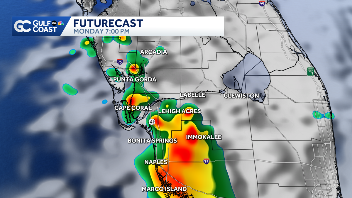
While the entire Gulf Coast will start out dry Monday, storms will develop again by the late afternoon.
>> WELL, THIS MORNING, IT IS OUR SECOND STRAIGHT GULF COAST WEATHER IMPACT DAY. WE’VE SEEN SOME CRAZY VIDEO FROM OUR VIEWERS, INCLUDING ONE THAT LOOKED LIKE MAYBE A LAND SPOUT US ON A GOOD USED TO LIKE, WHAT’S THE DIFFERENCE BETWEEN A LAND SPOUT OR TORNADO? AND THAT’S WHAT THE NATIONAL WEATHER SERVICE WILL BE DETERMINING LIKELY TODAY. THE BIGGEST DIFFERENCE IS JUST WHERE IT ORIGINATES. SO LET’S GET YOU. >> WHERE THIS WAS THIS HAPPENED AROUND 3.40, YESTERDAY AFTERNOON. SO THIS WAS IN CAPE CORAL, JUST SOUTH OF VETERANS. NOW, AS WE SAY, THE NATIONAL WEATHER SERVICE EITHER ASSESSED THE DAMAGE OR DO SOME MORE RADAR ANALYSIS TODAY. THE DETERMINING FACTOR WOULD BE WHERE DID THIS CIRCULATION ACTUALLY ORIGINATE WITH A LAND SPOUT? IT’S USUALLY FROM THE GROUND UP. IT’S A SURFACE BAY CIRCULATION THAT EXTENDS UP TOWARD A CLOUD, A TORNADO. AND IF THIS IS DETERMINED TO BE A TORNADO, LIKELY A WEAK EF 0 WITH WINDS. 65 TO 85 MILES PER HOUR. BUT THIS IS WHAT YOU THINK OF WITH A CLASSIC SEVERE THUNDERSTORM WARNING. THE ROTATION EXTENDS DOWN FROM THE CLOUD TO THE GROUND. SO REALLY, IT’S JUST A MATTER OF THE ORIGINATION. NOW, WE DO KNOW THAT WE’RE LOOKING AT SCATTERED STORMS AGAIN TODAY, BUT THIS IS NOT GOING TO BE A WASHOUT IN THE SEVERE WEATHER THREAT. NOT AS HIGH AS WHAT WE SAW YESTERDAY. STILL NOT RULING OUT SOME STRONG TO SEVERE STORMS, BUT FOR MANY COMMUNITIES, IT IS GOING TO BE THIS SAME POCKETS THAT JUST SAW THE SEVERE WEATHER YESTERDAY THAT ARE FAVORED TO SEE MORE ROUNDS OF STORMS AGAIN TODAY. SO IT IS A DRY START ON THIS MONDAY MORNING. THAT WON’T LAST FOR TOO LONG WITH SOME ISOLATED RAIN ALREADY BY 1, 2, 3 O’CLOCK. AND THEN SCATTERED STORMS. AND YOU CAN SEE RIGHT UP ALONG I-75 AND TO THE WEST ALL OVER AGAIN. SO THIS IS 4 O’CLOCK EVEN HEADING INTO HEAVY RAIN. THE LIGHTNING CONCERNED, BY THE WAY, THAT STORM THAT DID PRODUCE THAT POSSIBLE LANDSPOUT IN CAPE CORAL WAS THIS SAME STORM THAT PRODUCED HAIL REPORTS OVER 500 LIGHTNING STRIKES. SO THE STORMS PRODUCING NUMEROUS THREATS AS THE STORMS WIND DOWN TODAY, WE WILL BE BACK DOWN INTO THE MID 70’S AND WE’RE LOOKING AT COMFORTABLE CONDITIONS OVERNIGHT WITH MORE ROUNDS OF STORMS, ESPECIALLY NEAR COASTAL SPOTS TUESDAY, WEDNESDAY, HIGHS STILL IN THE LOW 90’S THROUGH THE WEEKEND. WE’RE STILL LOOKING AT RAIN OPPORTUNITIES SOMEWHERE ALONG THE GULF COAST. NOT EVERY DAY WILL BE A WASHOUT, BUT WE WILL HAVE SOME CHANCES EACH AND EVERY AFTERNOON AS WE FLIP THE SWITCH TO THE START OF THE RAINY SEASON. ALSO, SOME PRETTY IMPRESSIVE WIND GUST REPORTS COMING OUT OF SOME OF THOSE SEVERE STORMS YESTERDAY. WHISKEY CREEK, 50 MILE PER HOUR. WIND GUSTS THERE OUT OF RSW. 46 MILE PER HOUR. WIND GUSTS TODAY. WE STILL COULD SEE SOME PRETTY HIGH WIND GUST REPORTS. TECHNICALLY FOR THIS TO BE SEVERE, WE WOULD SEE WINDS CLOSER TO 60 MILES PER HOUR. BUT HEAVY RAIN. THE FLOODING CONCERN A POSSIBILITY AND THOSE GUSTY WINDS NOT RULING OUT SMALL HAIL LIKE WE SAW YESTERDAY LIKE IN CAPE CORAL ALL OVER AGAIN TODAY. HERE’S THE GOOD NEWS. EVEN THOUGH WE AT TIMES ARE DEALING WITH THIS STRONG THUNDERSTORM ACTIVITY. IT IS BRINGING US BENEFICIAL RAIN AS THE ENTIRE REGION STILL FACES EXTREME DROUGHT. WE HAVE MANY OPPORTUNITIES THIS WEEK TO FINALLY START CHIPPING AWAY AND MAKING SOME BI
Weather Impact Day Monday: More rounds of strong coastal storms
While the entire Gulf Coast will start out dry Monday, storms will develop again by the late afternoon.

Updated: 5:35 AM EDT May 18, 2026
After strong to severe storms brought damage to several Gulf Coast communities Sunday, today is another Gulf Coast Weather Impact Day as more storms develop this afternoon. Expect a dry start in the 70s but by the late afternoon and evening, scattered storms will work toward the coast. While the severe threat is much lower today, storms will still bring heavy rain, lightning and gusty winds. Ahead of the storms, get ready for another hot and humid day with highs in the 90s. After storms wind down after sunset, lows will fall into the mid 70s. An east wind will drive storms toward the coast over the next few afternoons. This will bring beneficial rain as our entire region continues to face extreme drought. However you watch or scroll, we’re committed to delivering your Gulf Coast Weather Most Accurate Forecast, one you can rely on every day, wherever you are.Live Interactive Radar: Track conditions in real time with the Gulf Coast Live Radar.Watch Gulf Coast Weather: Find the latest weather forecast videos, streaming live or on demand, on TV and online.Stream on the Go: Download the free Gulf Coast News app to watch on your phone or tablet.Your Gulf Coast Weather TeamChief Meteorologist Allyson RaeMeteorologist Caroline CastoraMeteorologist Jim DickeyMeteorologist Lauren HopeMeteorologist Raphael TavernierMeteorologist Rob DunsMeteorologist Sara BlueFollow on Social: Follow, like and subscribe to Gulf Coast News on social media to share your tips and be part of the conversation with Southwest Florida’s most experienced, trusted weather team: Facebook | Instagram | YouTube | TikTok | Threads | Bluesky | Nextdoor | XDOWNLOAD the free Gulf Coast News app for your latest breaking news and weather alerts. And check out the Very Local Gulf Coast app to stream news, entertainment and original programming on your TV.
After strong to severe storms brought damage to several Gulf Coast communities Sunday, today is another Gulf Coast Weather Impact Day as more storms develop this afternoon.
Expect a dry start in the 70s but by the late afternoon and evening, scattered storms will work toward the coast. While the severe threat is much lower today, storms will still bring heavy rain, lightning and gusty winds.
Ahead of the storms, get ready for another hot and humid day with highs in the 90s. After storms wind down after sunset, lows will fall into the mid 70s.
An east wind will drive storms toward the coast over the next few afternoons. This will bring beneficial rain as our entire region continues to face extreme drought.
However you watch or scroll, we’re committed to delivering your Gulf Coast Weather Most Accurate Forecast, one you can rely on every day, wherever you are.
Live Interactive Radar: Track conditions in real time with the Gulf Coast Live Radar.
Watch Gulf Coast Weather: Find the latest weather forecast videos, streaming live or on demand, on TV and online.
Stream on the Go: Download the free Gulf Coast News app to watch on your phone or tablet.
Your Gulf Coast Weather Team
Follow on Social: Follow, like and subscribe to Gulf Coast News on social media to share your tips and be part of the conversation with Southwest Florida’s most experienced, trusted weather team: Facebook | Instagram | YouTube | TikTok | Threads | Bluesky | Nextdoor | X
DOWNLOAD the free Gulf Coast News app for your latest breaking news and weather alerts. And check out the Very Local Gulf Coast app to stream news, entertainment and original programming on your TV.