
Tropical moisture to soak Central Florida this week: Flooding, widespread rain
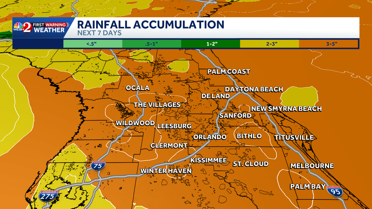
IN THE SUMMERTIME, I DON’T HAVE TO DO ANYTHING. WE JUST GET ENOUGH RAIN. AND WE’RE GEARING UP FOR MORE RAIN COMING OUR WAY. RIGHT GUYS? A LOT OF RAIN, A LOT OF RAIN. YOU KNOW, THEY ALWAYS SAY IT’S LIKE, YOU KNOW, FEAST OR FAMINE, RIGHT? JUST YOU WAIT BECAUSE, WELL, WE’VE BEEN FOR MONTHS DISCUSSING HOW DRY WE ARE. THE PATTERN IS SHIFTING. THIS IS JUST WHAT THE DOCTOR ORDERED. OKAY. BUT I’M TELLING YOU, IT’S GOING TO BE IMPACTFUL IN THAT THERE’S A LOT OF RAIN COMING. SO IMPACT WEATHER. THURSDAY, FRIDAY, SATURDAY, SUNDAY, EVEN MONDAY. OKAY. AND BASICALLY IT’S NOT, IT’S NOT JUST YOUR RUN OF THE MILL. TYPICAL AFTERNOON SHOWERS AND STORMS. WE’RE WATCHING BROAD LOWERING PRESSURES IN THE GULF. THIS IS NOT GOING TO BECOME A TROPICAL STORM OR A HURRICANE, BUT ESSENTIALLY WE’VE GOT TWO THINGS PLAYING OUT HERE. THE PRESSURES ARE LOWERING, FUNNELING UP MOISTURE. AND THEN THERE’S A COLD FRONT FROM THE NORTH TRAVELING DOWN AND JUST TRAPPING THIS FUNNEL RIGHT OVER TOP OF US. SO WE END UP WITH THIS WIND FLOW JUST PUMPING MOISTURE AND MOISTURE AND MOISTURE. SO WE’RE LOOKING AT A SEVERAL DAY RAIN EVENT WITH THE BIG CONCERN OF FLOODING AROUND CENTRAL FLORIDA. SO YOU’LL SEE ON THE SEVEN DAY FORECAST, WE DON’T DO THIS VERY OFTEN WHERE WE’VE GOT DAYS OF IMPACT WEATHER. BUT LOOK AT THAT RAIN COVERAGE 70 TO 80%. YEAH, WE’RE IN A SUMMER PATTERN WITH TODAY AND TOMORROW AT A 5,060%. BUT THERE’S THAT ADDED INCREASE. AND AT THE MOMENT, IT DOESN’T LOOK LIKE IT’S GOING TO BE A COMPLETE WASHOUT DAYS. IT JUST MEANS THAT WHEN WE GET INTO THE RAINS, THERE’S GOING TO BE A LOT. SO A COUPLE OF THINGS I WANT YOU TO KNOW THIS MORNING. THE MODELS CONTINUE TO BACK OFF ON ANY EVEN WHISPER OF TROPICAL ACTUAL DEVELOPMENT. IT’S JUST GOING TO BE RAIN AND A LOT OF IT. SO DEFINITELY HAVE TO KEEP TABS. AND TO GIVE YOU AN IDEA, THIS IS THE FORECAST. THIS IS NOT A MODEL. THIS IS THE FORECAST RAIN OVER THE NEXT SEVEN DAYS TIME, 3 TO 5IN WIDESPREAD. SO THAT IS EXCELLENT NEWS. ALTHOUGH THERE COULD BE SOME FLOODING LOCALIZED THAT WILL HAVE TO DEAL WITH. BUT WE’LL HELP YOU NAVIGATE. IN THE MEANTIME, HERE’S TODAY LUNCHTIME. LOOKING GOOD. POPPING UP THE SHOWERS, EVEN A FEW THUNDERSHOWERS. 3:00 AND YOU NOTICE BASICALLY ORLANDO OFF TO THE WEST IS GOING TO BE THE AREA THAT SEES THOSE RAINS TODAY. I ALSO NOTICE A SEABREEZE COLLISION LATE ABOUT 8:39 P.M. ALONG I-75. IF YOU LIVE OUT THERE, IT’S GOING TO BE KIND OF BEDTIME OR PAST YOUR BEDTIME. THUNDERSTORMS THAT WILL CONTINUE THROUGH 11:00. IT LOOKS LIKE THEN INTO TOMORROW MORNING NOTICE 5:00 FUTURECAST. STILL WITH THAT RAIN AROUND, QUIETING LATE MORNING TOMORROW. BUT BY ABOUT LUNCHTIME, DEVELOPING THE EAST COAST SEA BREEZE. AND THEN WE GET INTO A WIDER COVERAGE OF RAIN. THREE, FOUR, 5:00 KIND OF MORE CENTERED INTO THE METRO. SO RAIN CHANCES ARE GOING UP PORT CANAVERAL LOOKING QUIET THIS MORNING, 80 DEGREES THERE. IT’S MID 70S IN THE METRO AND INTO OUR NORTHERN AREAS. AND WE’RE WATCHING SOME RAINS HERE IN COASTAL VOLUSIA COUNTY. BUT FOR NOW, THAT’S ALL WE’VE GOT. HEADING TO THE BEACH TODAY. HIGH RISK OF RIP CURRENTS. SURF RUNNING 2 TO 3FT, LOTS OF MOISTURE. BUT WE’RE JUST GOING TO BE ADDING TO IT THESE NEXT COUPLE OF DAYS. SO 50% COVERAGE OF RAIN FOR US TODAY. TOMORROW IS 60% COVERAGE. AND THEN WE GET INTO THAT IMPACT WEATHER FOR LATE THIS WEEK INTO
Tropical moisture to soak Central Florida this week: Flooding, widespread rain

Updated: 9:04 AM EDT May 26, 2026
Tropical moisture will bring significant rainfall across Central Florida this week. Residents should expect increasing rain coverage each day.Starting Thursday, most of Central Florida will be under an Impact Weather alert through the weekend into next week. The biggest impacts are widespread showers and flooding threats. This is happening because low pressure in the Gulf is bringing in moisture, and a front from the north is pushing it down and holding it over Central Florida.Central Florida will be under Impact Weather from Thursday through Monday. Rain coverage will be between 70% and 80%.First Warning Weather Stay with WESH 2 online and on-air for the most accurate Central Florida weather forecast.RadarSevere Weather AlertsDownload the WESH 2 News app to get the most up-to-date weather alerts. The First Warning Weather team includes First Warning Chief Meteorologist Tony Mainolfi, Eric Burris, Marquise Meda, Cam Tran and Victoria Wisniewski.What is Impact Weather?Impact Weather suggests weather conditions could be disruptive or a nuisance for travel and day-to-day activities.
Florida —
Tropical moisture will bring significant rainfall across Central Florida this week.
Residents should expect increasing rain coverage each day.
Starting Thursday, most of Central Florida will be under an Impact Weather alert through the weekend into next week.
This content is imported from Twitter.
You may be able to find the same content in another format, or you may be able to find more information, at their web site.
The biggest impacts are widespread showers and flooding threats.
This is happening because low pressure in the Gulf is bringing in moisture, and a front from the north is pushing it down and holding it over Central Florida.
Central Florida will be under Impact Weather from Thursday through Monday. Rain coverage will be between 70% and 80%.
This content is imported from Twitter.
You may be able to find the same content in another format, or you may be able to find more information, at their web site.
First Warning Weather
Stay with WESH 2 online and on-air for the most accurate Central Florida weather forecast.
Download the WESH 2 News app to get the most up-to-date weather alerts.
The First Warning Weather team includes First Warning Chief Meteorologist Tony Mainolfi, Eric Burris, Marquise Meda, Cam Tran and Victoria Wisniewski.
What is Impact Weather?
Impact Weather suggests weather conditions could be disruptive or a nuisance for travel and day-to-day activities.