
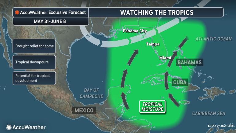
Warm Gulf and southwest Atlantic waters could support tropical development close to Florida in early June, while forecasters also track increasing activity in the eastern Pacific.
Published May 27, 2026 2:28 PM EDT
|
Updated May 27, 2026 3:39 PM EDT
In this Forecast Feed, AccuWeather’s Bernie Rayno monitors the Gulf, the Caribbean and the Carolina coastal region for potential homegrown tropical development as hurricane season begins on June 1.
Conditions from Mexico’s Yucatán Peninsula to the waters surrounding Florida could become more favorable for tropical development in the coming days.
“While we always monitor the tropics for potential threats, we’ll be keeping a close eye on the central and eastern Gulf and the southwestern Atlantic,” AccuWeather Lead Hurricane Expert Alex DaSilva said. “Climatologically, this region can experience early-season tropical development.”
“The chance of development remains very low in the short term due to strong wind shear,” DaSilva added. “However, as the shear relaxes, conditions could become more favorable for an area of low pressure to develop.”
AccuWeather’s team of tropical meteorologists believes the highest chance for tropical development would occur during the middle to latter part of next week.
“Sea-surface temperatures are running above average in these areas and are generally within a few degrees of 80 degrees, which is near the threshold typically needed for tropical development,” DaSilva said.
Should a storm form, where it develops would likely determine its track. A storm that forms over the central or eastern Gulf would be more likely to track northeastward. One that develops over the southwestern Gulf (the Bay of Campeche) could move westward into Mexico.
“Even if nothing develops, conditions through mid-June look wetter overall across Florida, which should help ease drought conditions,” DaSilva said.
GET THE FREE ACCUWEATHER APP
• Have the app? Unlock AccuWeather Alerts™ with Premium+
Significant rainfall will be needed to substantially reduce or end the drought. However, if a tropical depression or tropical storm tracks close enough to Florida, several inches of rain could fall and lead to localized flooding.
How rough seas become across the region will depend on the organization and strength of any storm. At the very least, locally heavy squalls, gusty winds and rapidly changing weather conditions could pose hazards for beachgoers and boaters from the northwestern Caribbean and Gulf to the southwestern Atlantic.
Meanwhile, in the Pacific, AccuWeather meteorologists expect one or two tropical storms to form over the next seven to 10 days, helping to kick off the active eastern Pacific hurricane season.
One feature may develop well off the coast of Central America and Mexico in the time frame of June 3-6.
A second feature is forecast to develop much closer to the coast of Central America a few days later. Steering winds could guide that storm toward the southwestern coast of Mexico.
While a strengthening El Niño is likely to suppress tropical cyclone activity in the Atlantic later this summer and autumn, it is forecast to boost activity in the eastern Pacific. El Niño is characterized by unusually warm water across parts of the tropical Pacific Ocean. Its impacts, including shifts in the jet stream, can influence weather patterns around the globe.
More stories of interest:
Want next-level safety, ad-free? Unlock advanced, hyperlocal severe weather alerts when you subscribe to Premium+ on the AccuWeather app. AccuWeather Alerts™ are prompted by our expert meteorologists who monitor and analyze dangerous weather risks 24/7 to keep you and your family safer.