
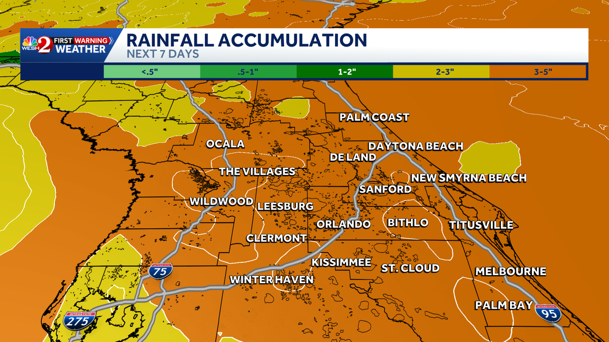
Tropical moisture will bring significant rainfall across Central Florida over the next several days. Residents should expect increasing rain coverage each day. Starting Thursday, most of Central Florida will be under an Impact Weather alert through the weekend into next week. Unlike the typical summer setup, rain could develop at nearly any time of day — not just in the afternoon. The biggest impacts are widespread showers and flooding threats. This is happening because low pressure in the Gulf is bringing in moisture, and a front from the north is pushing it down and holding it over Central Florida.Central Florida will be under Impact Weather from Thursday through Tuesday. Rain coverage will be between 70% and 80%. First Warning Weather Stay with WESH 2 online and on-air for the most accurate Central Florida weather forecast.RadarSevere Weather AlertsDownload the WESH 2 News app to get the most up-to-date weather alerts. The First Warning Weather team includes First Warning Chief Meteorologist Tony Mainolfi, Eric Burris, Marquise Meda, Cam Tran and Victoria Wisniewski.What is Impact Weather?Impact Weather suggests weather conditions could be disruptive or a nuisance for travel and day-to-day activities.
ORLANDO, Fla. —
Tropical moisture will bring significant rainfall across Central Florida over the next several days.
Residents should expect increasing rain coverage each day.
Starting Thursday, most of Central Florida will be under an Impact Weather alert through the weekend into next week.
This content is imported from Twitter.
You may be able to find the same content in another format, or you may be able to find more information, at their web site.
Unlike the typical summer setup, rain could develop at nearly any time of day — not just in the afternoon.
The biggest impacts are widespread showers and flooding threats.
This is happening because low pressure in the Gulf is bringing in moisture, and a front from the north is pushing it down and holding it over Central Florida.
Central Florida will be under Impact Weather from Thursday through Tuesday.
Rain coverage will be between 70% and 80%.
This content is imported from Twitter.
You may be able to find the same content in another format, or you may be able to find more information, at their web site.
A wet pattern continues to head our way over the next week. Rainfall amounts will definitely put a big dent in our drought. Here’s the latest setup ‘and rainfall totals. New runs are coming in now so I’ll have an update shortly. #weshwx pic.twitter.com/nUqFPAT796
— Tony Mainolfi (@TMainolfiWESH) May 28, 2026
First Warning Weather
Stay with WESH 2 online and on-air for the most accurate Central Florida weather forecast.
Download the WESH 2 News app to get the most up-to-date weather alerts.
The First Warning Weather team includes First Warning Chief Meteorologist Tony Mainolfi, Eric Burris, Marquise Meda, Cam Tran and Victoria Wisniewski.
What is Impact Weather?
Impact Weather suggests weather conditions could be disruptive or a nuisance for travel and day-to-day activities.