

TAMPA, Fla. — Hurricane season is here and we want to help you get prepared. In this guide, we talk with the Spectrum Bay News 9 meteorologists, local emergency officials and residents who are preparing themselves to be ready for whatever this season brings us. We will also share a lot of helpful information, including what to put in your hurricane kit, evacuation routes and maps, and what to do after the storm hits. Remember, taking steps now to prepare will help you better weather a storm in the future.
Let’s start off by looking back at the 2025 hurricane season. It marked the first time in decades that there was no direct landfall in the United States from a hurricane. But it was still an active season overall with 13 named storms. Three of those — Erin, Humberto and Melissa — reached Category 5 status.
One tropical storm, Chantal, did make landfall just one day after forming. Chantal moved inland near Litchfield Beach, S.C., as a tropical storm with winds of 60 mph on July 6. Despite Chantal’s status as a tropical storm, it still managed to bring heavy rainfall and flash flooding to the Carolinas. Radar-estimated totals of up to 9 to 12 inches were recorded in parts of North Carolina between Raleigh and Greensboro, causing significant flooding around Chapel Hill and nearby rivers.
So, even though the U.S. avoided hurricanes last year, it only took one storm to cause problems for those in the Carolinas.
GUIDE QUICK LINKS
— Choose a section —
Jump to any section of our guide by clicking on the links below:
EL NIÑO’S IMPACT
— What to expect —

Global weather patterns impact our hurricane season. La Niña and El Niño have to do with the water temperatures in the tropics of the Pacific Ocean.
Our weather experts say that El Niño is on its way this summer.
El Niño will likely develop near the beginning of hurricane season and strengthen through the rest of the year. This could have a big impact on how many storms we see this season.
Learn more about El Niño’s impact. →
FORECAST TRACK UPDATES
— Latest from NOAA and CSU —

There are a few terms we all recognize when it comes to hurricanes, and the cone is one of them.
The cone contains the probable path of the storm’s center, and it represents the potential error in the track forecast.
Tropical track forecasting has improved a little over the past five years. So for 2026, the forecast cone will be just a little narrower.
But it’s important to be prepared even if you are not in the cone.
For example, this is a look back at Hurricane Helene.
From 60 hours before landfall through landfall, most of west-central Florida and the Tampa Bay area that experienced storm surge was not in the cone.
This reminds us that tropical hazards can extend well beyond the cone.
And remember, hurricane conditions are still possible when you are in the cone, and certainly if you live in an area where a hurricane watch or warning is issued.
HURRICANE WATCH VS. WARNING

It’s also important to know the difference between a Hurricane Warning and a Hurricane Watch.
A “watch” announcement is when hurricane conditions are possible within the area.
This will be issued up to 48 hours in advance.
A warning is when hurricane conditions are expected somewhere within the specified area.
A warning is issued 36 hours in advance of the anticipated start of tropical force winds.
As a storm intensifies, the category increases.
A tropical storm becomes a hurricane when sustained winds reach 74 miles per hour.
And then the ranking scale depends on the storm’s sustained wind speed.
Category 1: Winds 74 – 95 mph
Category 2: Winds 96 – 110 mph
Category 3: Winds 111 – 129 mph
Category 4: Winds 130 – 156mph
Category 5: Winds 157 mph+
HURRICANE KIT
— Plan ahead and stock up —
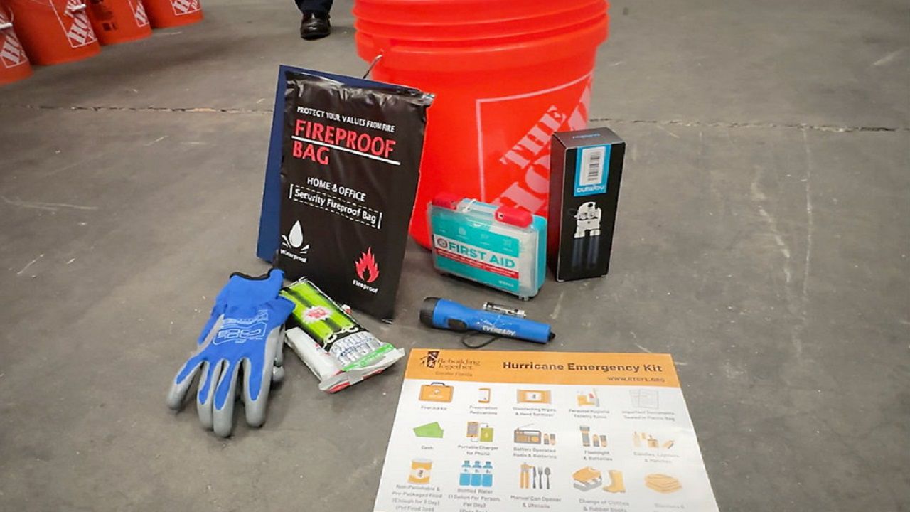
Rebuilding Together Tampa Bay is stockpiling common hurricane supplies to be packed in 5-gallon Home Depot buckets and distributed to impacted areas should Florida see a hurricane or storm damage this year. (Spectrum News/Chris McDonald)
Now is a great time to create your hurricane kit or stock up on one you may already have. Don’t wait for a storm to get a name because all eyes will be on the tropics. As the storm approaches, store shelves could empty. So, it’s best to buy everything you’ll need — and want — to have on hand way ahead of time. You don’t want to be caught trying to stock up at the last minute.
Here’s a list of all the basics:
Flashlights and extra bulbs
Battery-operated radio
Battery-operated lanterns
Extra batteries (various sizes)
Wind-up or battery-powered clock
Matches
First-aid kit
Duct tape
Rain gear
Plastic garbage bags
Fire extinguisher
Scissors
Can opener
Clean clothes
Extra blankets and pillows
Heavy gloves
Food
Bottled water (one gallon/person/day)
Two coolers (one for drinks, one for food)
Canned foods
Bottled juice
Dry pet food
OUR WEATHER EXPERTS
— Celebrating 20 years —
We have been your calm before, during and after the storm for decades. Chief Meteorologist Mike Clay has been here for 29 years. Meteorologists Juli Marquez, Josh Linker and Brian McClure have also been here for 20 years each. The newest member to our team, Meteorologist Kyle Hanson, has only been here a few seasons, but he has already been through some of the toughest storms the Tampa Bay area has had to deal with.
LOOKING BACK
— Hurricanes Helene and Milton —
PHOTOS: Milton’s Impact
Right now, Tampa Bay and the Nature Coast are still recovering from the one-two punch from hurricanes Helene and Milton.
In fact, Tampa Bay had not seen a direct hit from a major hurricane in more than a century, until Milton.
On Oct. 9, 2024, Hurricane Milton made landfall near Siesta Key, about 5 miles from Sarasota, as a Category 3 storm.
It brought heavy rainfall and damaging winds to our area.
It wrecked communities that were already struggling to recover from Helene.
PHOTOS: Helene’s Impact
TAKEAWAYS FROM HURRICANE CHARLEY
— Every storm is different —
Person examines damage and debris after Hurricane Charley slammed into Florida in August 2004. (File)
A Category 4 with winds near 150 mph at landfall, Hurricane Charley in 2004 was one for the record books and was followed by three more hurricanes in just six weeks.
When the season was all said and done, nearly every square inch of the state had been affected by one of the quartet of storms.
PREPARING YOUR HOME
— What you can do —

Landscaper working on a customer’s lawn. (Spectrum News/Lizbeth Gutierrez)
We can’t prevent a hurricane from coming, but we can minimize the damage to our homes. Here are a few ways you can prepare your home:
Protect your windows. This is very important because once a window is broken, the wind and the rain can wreck things inside.
Check and secure roof shingles or decking.
Reinforce all doors, including garage doors.
Trim trees and shrubs near your home.
Prepare your pool. Don’t drain it: the weight of the water keeps the pool from being lifted off its foundation. But put a cover on it if you have one.
Pull all outdoor furniture inside.
ELEVATING YOUR HOME
— Staying out of harm’s way —

A St. Petersburg home in Riviera Bay that was flooded by Hurricane Helene in 2024 was elevated about 14 feet up into the air in April. (Spectrum News/Josh Rojas)
One of the solutions to protect against flooding is to elevate your home. A Bay area builder says that after Helene and Milton, requests for his company to raise low-lying homes have skyrocketed.
Hurricane Helene sent a 6.3-foot storm surge into St. Petersburg on Sept. 26, 2024, which flooded 10,700 homes, and Hurricane Milton damaged an additional 4,904 homes by wind or rainwater flooding about two weeks later on Oct. 9, according to city records. The Special Flood Hazard Area covers 45% of St. Petersburg.
Here’s a look at how many homes are currently in the elevation process in St. Petersburg. →
County-by-County Storm Surge Zones:
STRENGTHENING HURRICANE RESPONSE
— Creating a new response plan —

Teams of deputies and first responders used airboats to rescue trapped families during Hurricane Helene. (Spectrum News/Angie Angers)
Disaster response is changing in Citrus County, after hurricanes Idalia and Helene rocked the Nature Coast.
In the early morning hours of Sept. 27, 2024, Crystal River was overwhelmed by the largest storm surge ever recorded in Citrus County, leaving roads underwater and residents trapped in their homes. As floodwaters rose, the Citrus County Sheriff’s Office launched overnight rescue operations using airboats to reach residents who were stranded in their homes.
As conditions worsened, law enforcement turned to local residents who owned personal airboats to assist with evacuations.
See how the success of this operation led to the creation of the Community Airboat Alliance. →
EVACUATION ORDERS
— Don’t just focus on the cone —

Evacuations ahead of Hurricane Charley (File)
We learn different lessons from every storm we face. In 2022, Hurricane Ian made landfall on Cayo Costa.
It was the first Category 4 hurricane to impact southwest Florida since Charley.
Ian caused catastrophic damage to counties like Lee, Collier and Charlotte.
Days leading up to landfall, the track of Ian was headed for Tampa Bay. Once it shifted, Lee County officials began issuing mandatory evacuation orders.
There was criticism of the timeline. Some say more time was needed, with the last order coming out less than 24 hours before landfall.
That was a day after some neighboring counties and two days after storm surge warnings.
County officials say the orders were late because of the slight shift.
But as we always say, you can’t just focus on the cone.
Hurricane Irma also devastated parts of southwest Florida in 2017.
Its size played a major role in its path of destruction.
As you can see, the storm spanned the entire width of the state.
And it was a very slow-moving storm.
As it headed towards us, mass evacuation orders were issued.
Highways had bumper-to-bumper traffic as people headed north.
According to Florida’s Department of Emergency Management, over 6 million Floridians evacuated their homes.
And we saw fuel shortages, as people filled up multiple gas cans and hoarded it to make sure they could make it out of the state.
Lee County officials say that southwest Florida is considered one of the hardest places in the country to evacuate in a disaster.
EVACUATION INFORMATION
— Know your zone and routes —
Type in your address to find out your evacuation zone.
County-by-County Evacuation Routes:
INSURANCE CLAIMS
— Document everything —

Resident Kerry Flynn (right) and a friend walk past a damaged home and tiki hut in their 55+ mobile home community after the passage of Hurricane Milton, on Manasota Key, in Englewood, Fla., on Oct. 13, 2024. (AP Photo/Rebecca Blackwell)
After the storm and once it’s safe to do so, you’ll want to file insurance claims.
Flood insurance and property insurance are separate policies.
You will need to submit claims for each.
So, here are some things to do once you are ready:
Have your policy number available.
Contact your insurance agent or company to report the claim.
Once officials give the all-clear and you return home, you can prepare for your inspection.
Make sure you document everything before cleaning up.
Take photos and videos of any damaged property, including items you plan to throw away.
You should have evidence of any structural damage, standing water and damage to all appliances and furniture.
Next, a claims adjuster will meet you to inspect your property.
Finally, the adjuster will work with you to submit an estimate of your loss.
Make sure you meet any deadlines given by your insurance company to ensure you receive an accurate payment.
PERMITTING PROCESS
— Varies county by county —

Workers assisting with permitting in St. Pete Beach. (Spectrum News/Josh Rojas)
Most people want to get to work right away fixing up their homes after a hurricane, but any repair work that normally requires a permit will still require a permit — even after a storm.
However, the process in Florida varies county by county, so before you do anything, make sure to check your county’s website.
Basic cleanup and minimal demolition are usually OK, but that work must be limited to damaged areas only.
For example, you should only remove the parts of a drywall panel that got wet.
One thing that is universal across the state is FEMA’s substantial damage rule, also known as the 50% rule.
It means if the cost to repair any damage to a home is more than 50% of the value of the property, homeowners have to upgrade the property to current flood codes.
County-by-County Home Pages:
HURRICANE RADIO PARTNERS
— Stay informed —

Courtesy: Getty Images
As a storm approaches the Bay area, staying aware with the latest information will be vital.
In addition to watching Spectrum Bay News 9, you can stay informed in a variety of ways. The following are our hurricane radio partners across the Bay Area:
Max @ 107.1 & 95.9 FM
Talk Radio 96.7 FM WLKF
WUSF 89.7 FM
WPCV 97.5 FM
WXJB 99.9 FM
WWJB 1450 AM/103.9 FM/92.3 FM
WWJB 103.9 FM & 92.3 FM
WXCV 95.3 FM
WXOF 96.7 FM
WGHR 106.3 FM
DOWNLOAD THE SPECTRUM NEWS APP
— Access Bay News 9 anywhere —

Download the Spectrum News App
Getting up-to-the-minute news can be paramount during a storm crisis, so be sure to download the Spectrum News App (iOS) (Google Play Store). With national reach, boots-on-the-ground local coverage and an unimpeachable weather team, we’ve got you covered during all of storm season.
The Spectrum News App’s Storm Season section is designed specifically to provide everything you need to know about hurricane season, from breaking weather reports to the latest news on what you’ll need to prepare for and get through any worst-case scenario, who to contact in an emergency and more. Our dedicated Weather Section provides even more comprehensive year-round coverage, including hour-by-hour forecasts and daily updates, facts and knowledge from hometown meteorologists with the experience and expertise that residents have trusted for decades. Klystron 9’s cutting-edge radar technology features hyperlocal data and temperature overlays, as well as long-range tropical system cone forecasts to help you plan ahead.