
Impact Weather: More downpours ahead with up to 4 inches possible in Central Florida
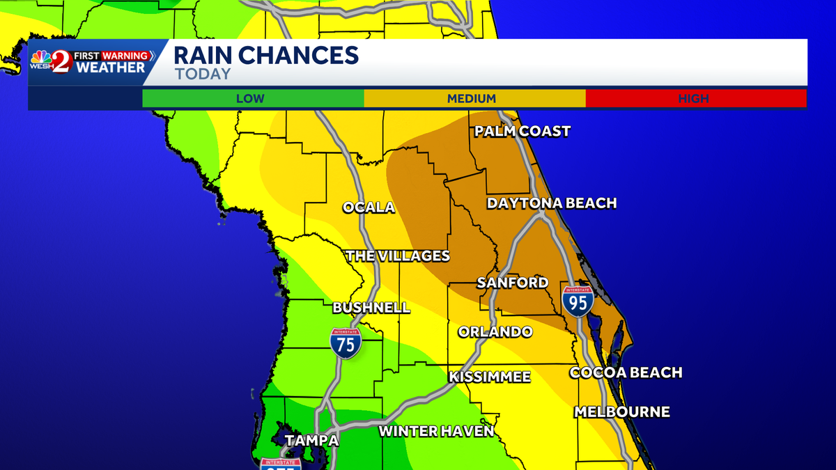
YOU CAN WATCH OUR SPECIAL ON WEDNESDAY AT 730, AFTER THE LOCAL NEWS AT SEVEN TONY. ONCE AGAIN BECAUSE TONY WE GOT TO GET THROUGH ANOTHER COUPLE OF DAYS OF ALL OF THIS WET WEATHER, AND THEN IT LOOKS LIKE WE’RE GOING TO BE, I’M AFRAID TO EVEN SAY WE’RE GOING TO BE DRY TOWARDS THE END OF THE WEEK. A RARE JUNE FRONT IS FORECAST TO COME THROUGH. SO WE THINK THURSDAY, FRIDAY AND SATURDAY ARE GOING TO BE PRETTY GOOD. AND WHEN YOU LOOK AT WHAT’S GOING ON OUTSIDE RIGHT NOW IN THE GULF IS ACTUALLY A LITTLE SPIN THERE TOWARDS THE BAY OF CAMPECHE. BUT YOU KNOW, WHAT, WITH THAT FRONT BACKING ON IN, THAT’S GOING TO KEEP THAT ENERGY AWAY, AWAY FROM CENTRAL FLORIDA WITH THE NORTHWESTERLY FLOW. SEE THAT ENERGY RIGHT THERE? THAT IS TOMORROW’S WEATHER COMING IN ON THE EASTERN SIDE OF THAT BIG DOME OF HIGH PRESSURE. IT’S GOING TO DROP SOUTH. WE ARE EXPECTING AN ACTIVE AFTERNOON TOMORROW. ACTIVE WEATHER THOUGH. RIGHT NOW WE’VE GOT A COUPLE SHOWERS POPPING HERE NORTHWEST OF BUSHNELL. NO LIGHTNING THERE. HERE’S THE BIGGER CONCERN. LOOK AT THE OUTFLOW BOUNDARY COLLIDING NOW WITH THE EAST BREEZE. AND THAT IS PRODUCING SOME LOCALLY VERY HEAVY RAIN RIGHT NOW RIGHT BY WICKHAM ROAD. RIGHT. ROCKLEDGE I 95 JUST IN TIME FOR THE EVENING COMMUTE. AND LOOK FOR AN UPTICK IN STORMS NOW IN AND AROUND KENANSVILLE POTENTIALLY DOWN TOWARDS PALM BAY. IF THIS DOES INDEED COME TOGETHER, MODELS SEEM TO BELIEVE THAT IT WILL. THE TRAJECTORIES LOOK PRETTY GOOD FOR REDEVELOPMENT, SO WE’LL WATCH THE TRENDS ON THIS AGAIN. NOT EXPECTING ANYTHING SEVERE, BUT 1 OR 2 STRONG STORMS COULD IMPACT FOLKS DRIVING TONIGHT OR JUST TRYING TO DO THINGS OUTSIDE. SO THERE’S PALM BAY SHOWERS AND STORMS THROUGH ABOUT 8:00. THEN WE WORK OUR WAY OVERNIGHT, WARM, MUGGY AND HUMID. LET’S TAKE A LOOK NOW OUR FUTURECAST GOOD IN THE MORNING HERE. THERE’S THE NOON HOUR WINDS. START PICKING ON UP. AND THEN LOOK AT THAT FRONT DROPS SOUTH NEAR I-10. LOOK AT THESE AFTERNOON SHOWERS AND STORMS. HEAVIEST STUFF UP TO THE NORTH. BUT SOME THAT WILL TRY TO BUILD OFF TOWARDS THE SOUTH AND EAST. AND EVEN WEDNESDAY MORNING WITH THE FRONT KIND OF COMING ON THROUGH. WINDS PICK UP OUT OF THE EAST NORTHEAST. LOOKS LIKE THE BEST CHANCES FOR SHOWERS AND STORMS ON WEDNESDAY IS GOING TO BE SOUTH OF ORLANDO. FLOOD THREAT TOMORROW IS THERE NORTH OF ORLANDO, AND THERE WILL BE THE RISK FOR 1 OR 2 STRONG TO SEVERE STORMS UP NORTH. NOT QUITE SURE THAT’S GOING TO MAKE IT THIS FAR SOUTH, BUT I CERTAINLY LIKE THE FOUR EIGHT UP TOWARDS THE NORTH. SO WE’LL WATCH THE TRENDS ON THAT AGAIN. FOR ME IT’S THE HEAVY RAIN AND THE LIGHTNING, NOT THE DAMAGING WINDS, TORNADOES AND HAIL THAT ARE BIGGEST CONCERNS, ALTHOUGH WE’LL REEVALUATE WITH EACH MODEL RUN COMING ON IN TEMPS TOMORROW. WARM AND HUMID, UPPER 80S LOW 90S. LET’S TALK ABOUT THAT FRONT. AS IT DROPS SOUTH, WE GET INTO SOME DRIER AIR, BUT ALSO MORE IMPORTANTLY, IT KEEPS THIS FEATURE WEST OF US. NOW, RAINFALL WISE THROUGH WEDNESDAY, WE COULD PICK UP AN ADDITIONAL 1 TO 3IN OF RAIN. BUT AS WE HEAD TO THE TROPICS AGAIN, WE’LL WATCH THAT FEATURE. BUT WE ARE NOT EXPECTING ANY DEVELOPMENT WITH A FRONT DROPPING ON IT. IT INCREASES THE WIND SHEAR. THE OTHER THING THAT INCREASES WIND SHEAR IS AN EL NINO. THAT’S WHAT WE HAVE SETTING UP THIS UPCOMING HURRICANE SEASON DOESN’T MEAN THAT WE CAN’T HAVE A STORM. IT MEANS THAT OVERALL, GENERALLY SPEAKING, IT CAN LOWER THE OVERALL NUMBER OF STORMS. THE SAHARAN DUST DOES THAT, AND SOME OF THAT DUST IS GOING TO MAKE IT INTO THE CARIBBEAN HERE, AWFULLY CLOSE TO FLORIDA. BY THE TIME WE GET TO LATE FRIDAY AND SATURDAY. BOTTOM LINE, IT ONLY TAKES ONE STORM TO MAKE IT AN ACTIVE SEASON. MAKE SURE YOU AND YOUR FAMILY HAVE THOSE ACTION PLANS READY TO GO. LOVI
Impact Weather: More downpours ahead with up to 4 inches possible in Central Florida

Updated: 6:43 PM EDT Jun 1, 2026
Multiple rounds of rain move through the region, bringing an additional 2 to 4 inches of rainfall. Impact Weather is expected across Central Florida through Wednesday. A very late-season cold front is forecast to arrive Wednesday, ushering in cooler temperatures for the middle and latter part of the week.The front also will bring drier air, leading to a decrease in rain chances beginning Thursday and continuing through the weekend.Monday also marks the start of the 2026 Atlantic hurricane season, which officially begins June 1 and runs through Nov. 30.First Warning WeatherStay with WESH 2 online and on-air for the most accurate Central Florida weather forecast.RadarSevere Weather AlertsDownload the WESH 2 News app to get the most up-to-date weather alerts.The First Warning Weather team includes First Warning Chief Meteorologist Tony Mainolfi, Eric Burris, Marquise Meda, Cam Tran and Victoria Wisniewski. What is Impact Weather?Impact Weather suggests weather conditions could be disruptive or a nuisance for travel and day-to-day activities.DOWNLOAD the free WESH 2 News app for your latest news and alerts on breaking news, weather, sports, entertainment and more on your phone or tablet. And check out the Very Local app to stream news, entertainment and original programming on your TV.
Multiple rounds of rain move through the region, bringing an additional 2 to 4 inches of rainfall.
Impact Weather is expected across Central Florida through Wednesday.
A very late-season cold front is forecast to arrive Wednesday, ushering in cooler temperatures for the middle and latter part of the week.
The front also will bring drier air, leading to a decrease in rain chances beginning Thursday and continuing through the weekend.
Monday also marks the start of the 2026 Atlantic hurricane season, which officially begins June 1 and runs through Nov. 30.
First Warning Weather
Stay with WESH 2 online and on-air for the most accurate Central Florida weather forecast.
Download the WESH 2 News app to get the most up-to-date weather alerts.
The First Warning Weather team includes First Warning Chief Meteorologist Tony Mainolfi, Eric Burris, Marquise Meda, Cam Tran and Victoria Wisniewski.
What is Impact Weather?
Impact Weather suggests weather conditions could be disruptive or a nuisance for travel and day-to-day activities.
DOWNLOAD the free WESH 2 News app for your latest news and alerts on breaking news, weather, sports, entertainment and more on your phone or tablet. And check out the Very Local app to stream news, entertainment and original programming on your TV.