
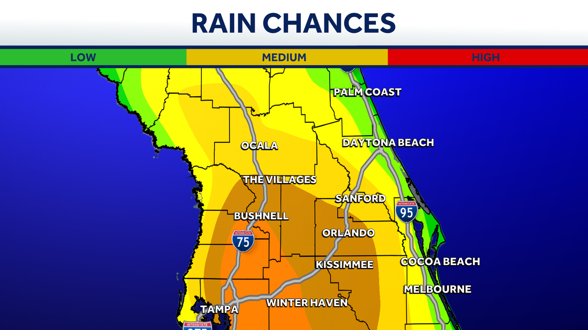
Rain chances climb to 70% as storms build across Central Florida this week
Had some, I mean, temperatures in the 60s. It’s nice. What that was yesterday though. Today it’s *** lot warmer to start. It’s like, yeah, it’s like we’re just, we’re getting back into it and then you throw an earthquake in for fun and uh, you know, Florida’s going to Florida. Love that. All right, so for today, *** 30% coverage of rain. It’s not going to pour down on all of us. Matter of fact, if we take *** look at our Futurecast model this morning, it’s painting in some of these quick passing coastal showers. Notice through the day those showers will try to sneak on in and it’s. Not *** washout, but there will be some rains around. Then we look ahead to tomorrow, 50% coverage of rain, same idea. Start off with the coastal showers, but notice we’re going to get more rains pushing across the inland spots and eventually piling up out west. Thursday into Friday, that’s when that pattern really starts to shift, but I want you to notice Friday, while yes, it’s the higher coverage of rain, the humidity really plays into things, and on Friday our feels like temperatures. Start to climb into the upper range of the 90s feeling like nearly 100 degrees and I’ve had *** few questions. I say *** few, literally everybody’s already asking the weekend, is it *** washout? And the good news is while that is *** 70% coverage of rain, notice future cast at 7 a.m. Quiet. It’s going to be afterward. Normal afternoon thunderstorms get going. They’re just going to be particularly widespread and then the same thing plays out looking ahead to Sunday. So that said, Today we just kind of start getting back into that summer’s pattern. *** few coastal showers this morning, but bringing up that rain coverage in earnest through the afternoon. That said, this morning, looking over to the tourist district, it is lovely, but it is much muggier, much warmer. 75 degrees, the current temperature in the city. It’s 71 outside into land, 70 degrees in Ocala, and live radar showing *** few sprinkles. First we’ll start right around Dunlawton here in Port Orange, crossing over US 1, crossing. Through Spruce Creek Road getting out to Taylor Road and 4:15 and then *** few other showers, even heavier rains coming into Flagler County with more rains just off the shoreline, all thanks to that onshore breeze. All going to continue to bring these showers on in. So today 30% coverage of rain starting at the coast, then working inland through the afternoon. Tomorrow 50/50 shot of seeing it, and then Thursday, Friday, Saturday, the pattern just continues to get wetter and wetter. So my advice, Megan, is probably throw the umbrella in the car this morning.
Rain chances climb to 70% as storms build across Central Florida this week

Updated: 10:48 AM EDT Jun 9, 2026
Storm chances are going up across Central Florida. The region has been experiencing drought conditions, but relief is expected this week as the chance of rain continues to increase into the weekend.On Tuesday, increased moisture will lead to scattered storms developing across the area.As the week progresses, storm chances will increase. By Wednesday, rain coverage is expected to reach 50 percent, with showers starting along the coast and gradually moving inland.Thursday into Friday, rain chances will be between 60 and 70%. Even with the highest chance of rain on Friday, temperatures are forecast to feel near 100 degrees.The rainy conditions will continue through the weekend. First Warning WeatherStay with WESH 2 online and on-air for the most accurate Central Florida weather forecast.RadarSevere Weather AlertsDownload the WESH 2 News app to get the most up-to-date weather alerts.The First Warning Weather team includes First Warning Chief Meteorologist Tony Mainolfi, Eric Burris, Marquise Meda, Cam Tran and Victoria Wisniewski.
ORLANDO, Fla. —
Storm chances are going up across Central Florida.
The region has been experiencing drought conditions, but relief is expected this week as the chance of rain continues to increase into the weekend.
On Tuesday, increased moisture will lead to scattered storms developing across the area.
As the week progresses, storm chances will increase. By Wednesday, rain coverage is expected to reach 50 percent, with showers starting along the coast and gradually moving inland.
Thursday into Friday, rain chances will be between 60 and 70%.
Even with the highest chance of rain on Friday, temperatures are forecast to feel near 100 degrees.
The rainy conditions will continue through the weekend.
First Warning Weather
Stay with WESH 2 online and on-air for the most accurate Central Florida weather forecast.
Download the WESH 2 News app to get the most up-to-date weather alerts.
The First Warning Weather team includes First Warning Chief Meteorologist Tony Mainolfi, Eric Burris, Marquise Meda, Cam Tran and Victoria Wisniewski.