
Beginning this weekend, the heat is expected to pick up as we enter a dangerous stretch of “feels like” temperatures, according to WESH 2’s First Warning Weather Chief Meteorologist Tony Mainolfi.The feels-like temperatures have the potential to reach triple digits, with areas in Orange County, Lake County and Seminole County reaching up to 103 degrees.WESH 2’s First Warning Weather team is advising Central Floridians to stay hydrated as the heat stress on the body rises.Looking aheadThe feels-like temperatures will continue to rise on the coast as we head into next week.Areas on the coast such as Daytona Beach, New Smyrna Beach and Titusville will be feeling like 100 degrees and higher.According to the National Weather Service, the humidity is expected to rise, and in turn, is causing the increase in heat risk into next week.Summer is almost hereThe official start of summer is June 21.According to WESH 2’s First Warning Weather team, the average high temperature is 91 degrees, and the average low is 72 degrees.Central Floridians can expect almost 14 hours of sunlight each day.First Warning Weather Stay with WESH 2 online and on-air for the most accurate Central Florida weather forecast.RadarSevere Weather AlertsDownload the WESH 2 News app to get the most up-to-date weather alerts. The First Warning Weather team includes First Warning Chief Meteorologist Tony Mainolfi, Eric Burris, Marquise Meda, Cam Tran and Victoria Wisniewski.What is Impact Weather?Impact Weather suggests weather conditions could be disruptive or a nuisance for travel and day-to-day activities.What is a Severe Weather Warning Day?A Severe Weather Warning Day suggests weather conditions that could potentially harm life or property. ————————————————DOWNLOAD the free WESH 2 News app for your latest news and alerts on breaking news, weather, sports, entertainment and more on your phone or tablet. And check out the Very Local app to stream news, entertainment and original programming on your TV.
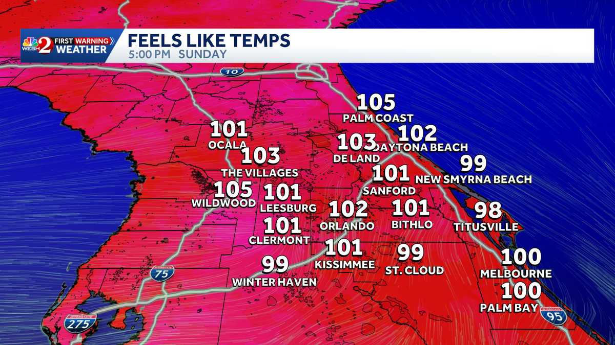
Beginning this weekend, the heat is expected to pick up as we enter a dangerous stretch of “feels like” temperatures, according to WESH 2’s First Warning Weather Chief Meteorologist Tony Mainolfi.
The feels-like temperatures have the potential to reach triple digits, with areas in Orange County, Lake County and Seminole County reaching up to 103 degrees.
WESH 2’s First Warning Weather team is advising Central Floridians to stay hydrated as the heat stress on the body rises.
This content is imported from Twitter.
You may be able to find the same content in another format, or you may be able to find more information, at their web site.
Looking ahead
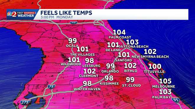
The feels-like temperatures will continue to rise on the coast as we head into next week.
Areas on the coast such as Daytona Beach, New Smyrna Beach and Titusville will be feeling like 100 degrees and higher.
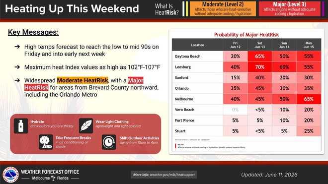
According to the National Weather Service, the humidity is expected to rise, and in turn, is causing the increase in heat risk into next week.
This content is imported from Twitter.
You may be able to find the same content in another format, or you may be able to find more information, at their web site.
June 11 | Scattered afternoon showers & storms this afternoon will mainly focus over the interior. Slow moving storms could lead to locally heavy rainfall, with a few strong wind gusts possible. Looking ahead, higher humidity will increase the HeatRisk this weekend. pic.twitter.com/pdGCT1wp4a
— NWS Melbourne (@NWSMelbourne) June 11, 2026
Summer is almost here
The official start of summer is June 21.
According to WESH 2’s First Warning Weather team, the average high temperature is 91 degrees, and the average low is 72 degrees.
Central Floridians can expect almost 14 hours of sunlight each day.
This content is imported from Twitter.
You may be able to find the same content in another format, or you may be able to find more information, at their web site.
The offcial start of #Summer is June 21st when the average high temperature is 91 and average low is 72. Sunrise is 6:28 AM and Sunset is at 8:26 PM. That’s 13 hours and 57 minutes of daylight. #weshwx pic.twitter.com/PBXqnbBarf
— Tony Mainolfi (@TMainolfiWESH) June 11, 2026
First Warning Weather
Stay with WESH 2 online and on-air for the most accurate Central Florida weather forecast.
Download the WESH 2 News app to get the most up-to-date weather alerts.
The First Warning Weather team includes First Warning Chief Meteorologist Tony Mainolfi, Eric Burris, Marquise Meda, Cam Tran and Victoria Wisniewski.
What is Impact Weather?
Impact Weather suggests weather conditions could be disruptive or a nuisance for travel and day-to-day activities.
What is a Severe Weather Warning Day?
A Severe Weather Warning Day suggests weather conditions that could potentially harm life or property.
————————————————
DOWNLOAD the free WESH 2 News app for your latest news and alerts on breaking news, weather, sports, entertainment and more on your phone or tablet. And check out the Very Local app to stream news, entertainment and original programming on your TV.