
TALLAHASSEE, Fla. (WCTV) – A global weather pattern has been taking shape for months and has now officially been established in the Eastern Pacific Ocean.
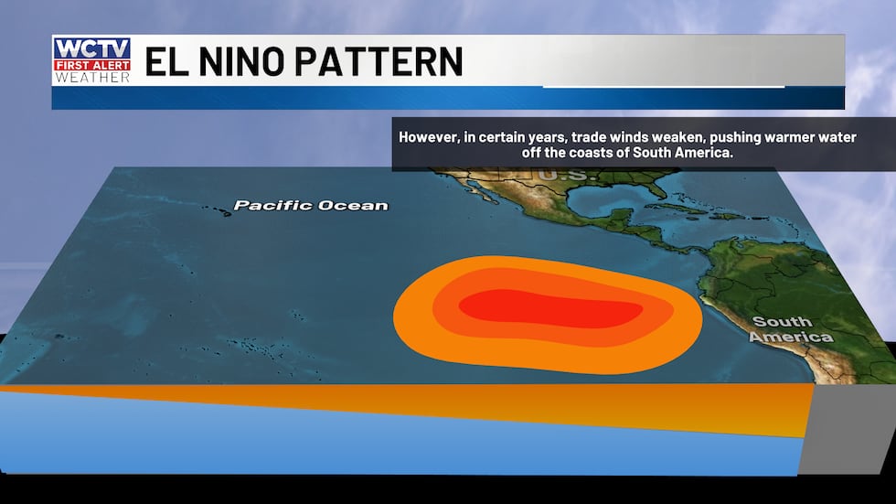 El Niño occurs when trade winds weaken or relax and allowing sea surface temperatures to rise in the Equatorial Pacific.(WCTV)
The Climate Prediction Center (CPC) has announced that El Niño is here. “Conditions are present and expected to strengthen into the Northern Hemisphere winter 2026-27.”
El Niño is the gradual warming of the eastern Pacific Ocean, which leads to a more active subtropical jet stream. This can impact the weather on a global scale, including our weather locally.
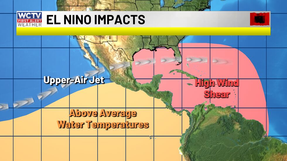 El Niño is associated with warmer sea surface temperatures in the Eastern Pacific. This can lead to higher wind shear, which tears tropical cyclones apart.(WCTV)Hurricane season:
When the subtropical jet stream is strong, wind shear is more common over the Caribbean Sea and the Atlantic Ocean.
Wind shear is when winds get stronger and change direction with height. The stronger wind shear can tear tropical storms and hurricanes apart.
That does NOT mean hurricanes cannot form, however, the wind shear makes it more difficult. Storms can develop during periods of lighter wind shear, and those are the ones to keep an eye on during the season.
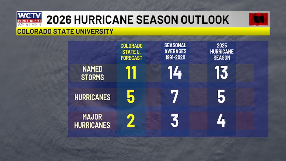 CSU has lowered the forecast number of storms in their June update, forecasting 11 named storms and 5 hurricanes.(WCTV)Severe Weather Season:
El Niño is expected to peak late fall into early winter, according to the CPC and could be one of the strongest events in history.
“There is a 63% chance of a very strong El Niño during November-January, which would rank among the largest El Niño events in the historical record going back to 1950.”
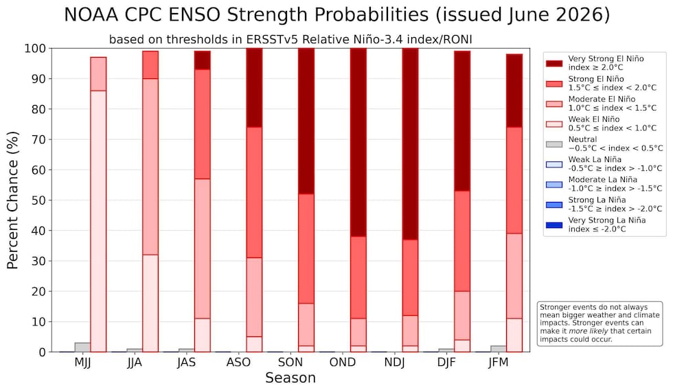 El Niño is likely to become very strong, especially by late fall and early winter.(NOAA/Climate Prediction Center)
The peak of the event could mean trouble for our severe weather season.
Looking back at data going back to 1950, severe weather, including tornadoes, is more frequent in El Niño years.
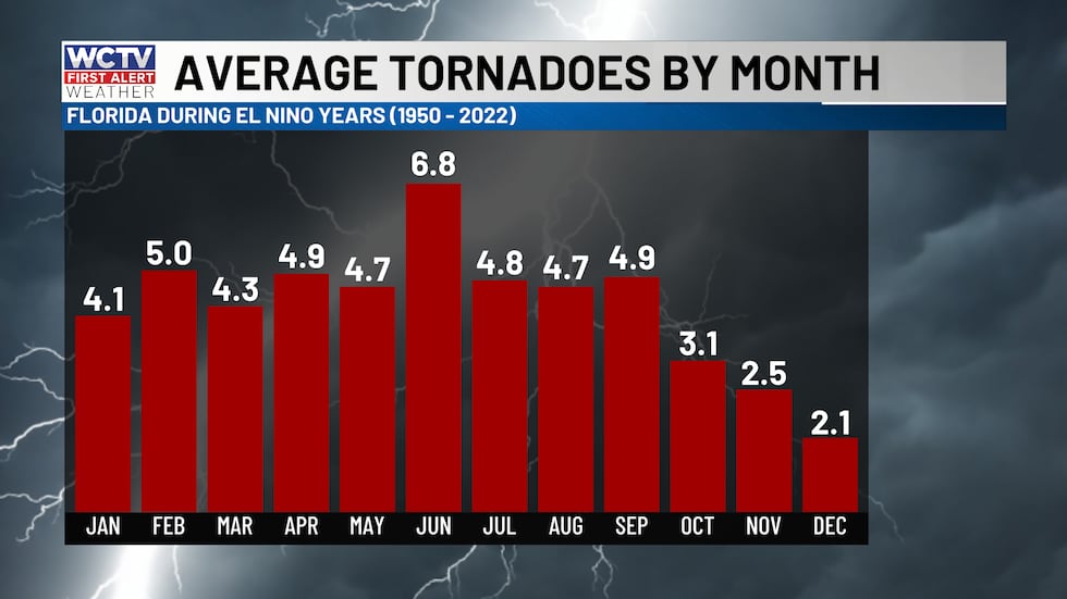 Average tornado reports in Florida during El Niño years. January, February and April tend to be the most active for tornadoes going back to 1950 during El Niños.(WCTV)
Dating back to historic data since 1950, the highest increase in tornadoes is in the months of January, February and April during El Niños.
One interesting note. October sees fewer tornadoes during El Niño events. This is likely tied to a lower number of tropical cyclones, as the global circulation often limits tropical development. March and May are the other two months that see fewer tornadoes statistically.
The most recent El Niño occurred in 2023 – 2024, which is when the May 10 tornadoes tore through Tallahassee.
MonthAverage Number
of Tornadoes
(1950-2022)Number of
Tornadoes
during El Niño yearsDifference January2.94.1+1.2February2.75.0+2.3March4.64.3-0.3April3.94.9+1.0May4.84.7-0.1June6.56.8+0.3July4.74.8+0.1August4.54.8+0.2September4.84.9+0.1October3.33.1-0.2November2.12.5+0.4December2.12.1+0.0
Bottom line, with an El Niño now here to stay for the next several months, we will need to monitor weather extremes ot just through hurricane season, but into the winter months as severe weather season kicks off in the fall and winter.
To stay updated on all the latest forecasts and weather, follow WCTV First Alert Weather on Facebook and X (Twitter).
Click here to see all the latest weather headlines and here to view the First Alert Radar. Receive push alerts and watch the latest forecast anytime on the free WCTV First Alert Weather app. Click here to download it now.
Interested in becoming a WCTV First Alert Weather Watcher? Click here to join the team!
Copyright 2026 WCTV. All rights reserved.