
Get ready, Florida:Abrutal summer heat wave could beon the way.
Starting late next week, a possibly gnarly combination of hot temperatures and high humidity could lead to dangerous heat indices across the state, including Tampa Bay.
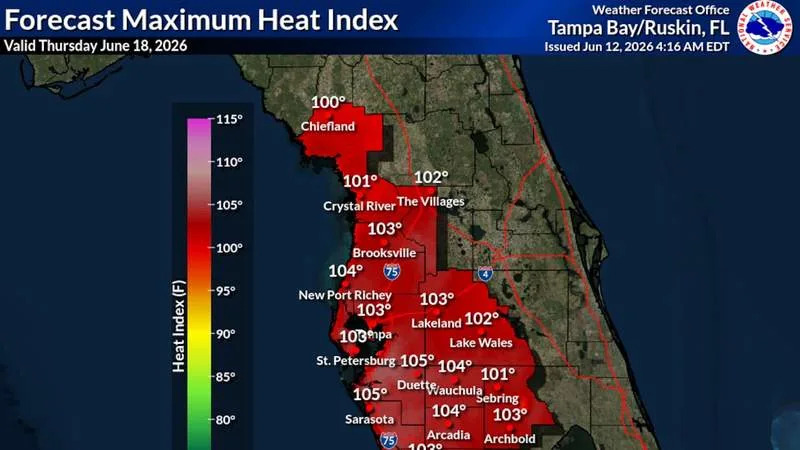
A National Weather Service map showcasing heat risk depicted much of Central Florida under a Level 3 “major” risk on Thursday. That’s the type of heat that can affect anyone without access to cooling or water, the agency said, and could become dangerous.
That day — the furthest available forecast graphic — shows the heat index climbing to around 103 degrees in Tampa. In Sarasota, it could reach 105.
The heat index is a mix of air temperature and humidity. The blend of the two is often referred to as the “feels-like” temperature — how outside temperatures feel on our bodies.
Federal forecasters also put out a warning for a “moderate risk of extreme heat” from June 19 through June 23. The warning encompasses all of Central and South Florida.
“It’s not often NOAA alerts Florida about the risk of extreme heat,” Jeff Berardelli, chief meteorologist for WFLA News Channel 8, wrote on social media Thursday.
Berardelli said widespread heat indices up to 110 degrees are possible.
Floridians are no stranger to sweltering temperatures and suffocating humidity, but late next week is likely to be one of the first major warmups of the summer.
“Looks like next week is going to be a sauna,” Denis Phillips, chief meteorologist for Tampa Bay 28, wrote on Facebook Thursday.
The forecast is still a week out, and things could change, said Paul Close, a meteorologist for the National Weather Service’s Tampa Bay office.
This weekend into next week is likely to bring more typical June weather, with temperatures topping out in the low 90s and lows around the upper 70s and low 80s. The heat index is likely to hover around 100 degrees.
Unfavorable wind conditions means coastal areas are less likely to see afternoon showers over the next several days. The best chances will be around inland areas or Florida’s east coast, Close said.
The mounting mugginess late next week will stem from continued low rain chances along the coast and a weather pattern that’s likely to lead to less cloud cover and increasing temperatures.
Close said the dew point — essentially the amount of moisture in the air — could rise into the upper 70s or low 80s, which will make the outside feel like a steam bath.
More typical dew points for this time of year are around the low 70s.
Should the forecast remain solid, or show ballooning heat indices, Close said the weather service could issue heat advisories or warnings.

Temperatures have steadily risen over the past few months. And even then, it was hot.
Last month,several spots landed in the top three hottest Mays on record for Tampa Bay locations, according to the weather service.
St. Petersburg had its second-warmest May, and Lakeland recorded its hottest ever.
Spring temperatures also outpaced typical temperatures for the area. St. Petersburg had its hottest spring ever, averaging nearly 79 degrees and finishing at about 4.6 degrees above normal.
Tampa Bay followed a larger trend within the United States and globally.
This past spring was the second-hottest on record in the contiguous U.S., according to the National Centers for Environmental Information. And May was the second hottest on Earth, researchers reported.
The long-term upward trend in temperatures remains on par with the consequences of human-caused climate change, according to Yale Climate Connections, a news site from the Yale Center for Environmental Communication.
Florida has one of the highest percentages of households that use AC equipment, at about 96%, according to a 2020 survey from the U.S. Energy Information Administration. In much of the state, residents are often just a searing hot parking lot away from AC.
But for those without access to cooling, Florida’s extreme heat is particularly perilous.
Our bodies’ ability to sweat is often strained by the region’s high humidity.
When a person sweats, heat is pulled away from their body, thus cooling them down. When humidity levels are high, the air becomes saturated with water, and a person’s ability to cool lags.
Those who spend long periods of time outside, like homeless people or outdoor workers, are most vulnerable to high temperatures.
Children and older adults, who already struggle to regulate temperatures, are also most sensitive to heat.
The blast of hot weather is likely just the beginning of more scorching weather to come this year. Federal forecasters are anticipating a higher probability of warmer-than-average temperatures this summer in Florida.
 How to prevent heat illnesses
Heat illness can fall on a spectrum. It can start with cramps or a rash, but in severe cases — when a person’s body temperature soars to around 104 degrees — it can lead to heatstroke.
If you can, only spend time outside during the coolest hours of the day, in the morning and at night. Access to water and hydration breaks are essential.
If you develop a rash, stomach cramps, headaches or nausea, get out of the sun and into a shaded or air-conditioned area to cool down. Often, this is enough to safely bring down a person’s body temperature.
Doctors also suggest shedding clothes to allow for more sweating.
For additional cooling, place a wet towel on your neck or ice packs on your head and armpits. Throwing water on a person can also help.
If you notice someone acting differently or showing changes in their mental status, call 911 and cool them immediately.
For more on heat risks, check out the Center for Disease Control’s website.
• • •
The Tampa Bay Times launched the Environment Hub in 2025 to focus on some of Florida‘s most urgent and enduring challenges. You can contribute through our journalism fund by clicking here.