
Impact Weather: Central Florida under heat advisory as feels like temps climb to 110°
KEEPING HYDRATED, FREQUENT BREAKS, AIR CONDITIONING, ALL OF THAT STUFF. LOOK AT THESE FEELS LIKE TEMPERATURES. OKAY. 4 P.M. TODAY, THIS IS WHERE I THINK WE’RE GOING TO END UP AT OUR PEAK PERFORMANCE. 107 IS HOW IT WILL FEEL IN ORLANDO WITH THAT HEAT INDEX 108 IN WILDWOOD. BUT LOOK ALONG THE SHORELINE 109 110 111. THE HEAT INDEX, JUST SO WE’RE ALL ON THE SAME PAGE. IT’S A FANCY MATH EQUATION THAT TAKES THE AIR TEMPERATURE, ADDS IN THE MOISTURE, AND GIVES US THE FEELS LIKE TEMPERATURE. SO HERE’S THE NUMBERS. THIS IS WHAT THE COMPUTERS EQUATING. OBVIOUSLY I’M NOT GOING TO READ THAT FORMULA, BUT JUST SO THAT, YOU KNOW, I MEAN, THERE’S A LOT OF DATA THAT GOES INTO THIS. SO IT REALLY IS A REAL THING. SO HEAT ADVISORIES ARE POSTED BECAUSE ALL OF US ARE RUNNING THOSE FEELS LIKE TEMPERATURES ANYWHERE FROM 105 TO 110 DEGREES. THE GOOD NEWS TODAY IS THAT WE HAVE AN INCREASING COVERAGE OF SHOWERS AND THUNDERSHOWERS. SO LET’S LOOK AT THE SEVEN DAY FORECAST TOGETHER TODAY 96 THE ACTUAL TEMPERATURE. BUT WE HAVE A 60% COVERAGE OF RAIN. LUNCHTIME. WE’RE GOOD. BUT JUST AFTERWARD WE’RE GOING TO START SPARKING UP RAINS OUT WEST. AND THEN LITTLE BY LITTLE, THREE 4:00 PM SHOWERS AND THUNDERSHOWERS FAIRLY WIDESPREAD. AND THEN WORKING OVER TOWARD I 95 TOMORROW, I WANT YOU TO NOTICE RAIN COVERAGE ACTUALLY INCREASES. AND WE’RE EVEN LOOKING AT A LOW END, ISOLATED RISK OF STRONG TO SEVERE STORMS ACROSS OUR AREA. WE’LL HAVE TO WATCH THE TRENDS TO SEE JUST HOW FEISTY THINGS GET. BUT LOOKING THROUGH TO THE WEEKEND, RAIN COVERAGE CONTINUES TO BUILD FOR SATURDAY. SUNDAY. THAT’S THE FIRST DAY OF SUMMER. THAT’S FATHER’S DAY. RAIN COVERAGE COMES DOWN A LITTLE BIT. BUT NOTICE THOSE TEMPERATURES START TO CLIMB AGAIN AND STAY UP RIGHT THROUGH TO NEXT WEEK. NOW, IN TERMS OF TEMPERATURES, I THOUGHT THIS WAS INTERESTING. ANECDOTALLY. TODAY’S FORECAST IS 96. TODAY’S RECORD IS 101. AS A MATTER OF TODAY IS ONE OF THE DAYS WHERE OUR RECORD HAPPENS TO BE THE HOTTEST TEMPERATURE EVER SET BACK IN 1921 AND 1927. AND NO, THERE ARE NO RECORDS IN THE FORECAST TODAY. THEY’RE JUST TOO HOT. BUT IT’S GOING TO BE PLENTY HOT TODAY. ALL RIGHT, OUTSIDE WE GO. KENNEDY SPACE CENTER LOOKING GREAT. UPPER 70S, LOWER 80S AROUND TOWN. AND THERE’S NOTHING SHOWING UP ON OUR FIRST WARNING LIVE RADAR. SO 96 DOES IT IN ORLANDO, 95 IN TITUSVILLE 95 IN SAINT CLOUD. BUT OF COURSE THE HEAT INDEX MAKES IT FEEL THAT MUCH ROUGHER. BUILDING UP RAIN CHANCES THE NEXT COUPLE OF DAYS AND THEN FOR NEXT WEEK, THE HEAT CONTINUES. COASTAL SEVEN DAY FORECAS
Impact Weather: Central Florida under heat advisory as feels like temps climb to 110°

Updated: 6:26 AM EDT Jun 18, 2026
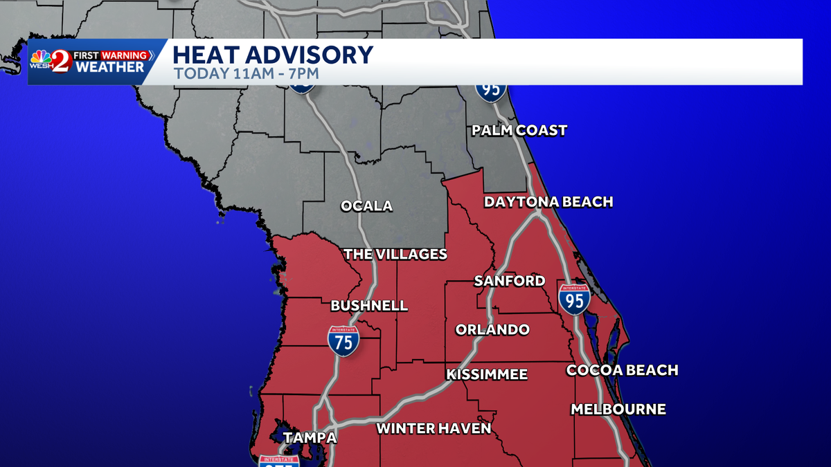
Central Florida is under a heat advisory as feels-like temperatures climb to dangerous levels on Thursday. Heat index values will soar into the 105° to 110° range across the region, peaking around 4 p.m.However, rain chances are expected to increase to around 60%, which could provide some relief from the heat. Showers and thunderstorms are expected to develop west of the area around 2 p.m. and move east through the afternoon, helping bring temperatures down.The worst conditions will be between 11 a.m. and 7 p.m.>> What is Impact Weather?Impact Weather suggests weather conditions could be disruptive or a nuisance for travel and day-to-day activities.First Warning Weather Stay with WESH 2 online and on-air for the most accurate Central Florida weather forecast.RadarSevere Weather AlertsDownload the WESH 2 News app to get the most up-to-date weather alerts. The First Warning Weather team includes First Warning Chief Meteorologist Tony Mainolfi, Eric Burris, Marquise Meda, Cam Tran and Victoria Wisniewski.
ORLANDO, Fla. —
Central Florida is under a heat advisory as feels-like temperatures climb to dangerous levels on Thursday.
Heat index values will soar into the 105° to 110° range across the region, peaking around 4 p.m.
However, rain chances are expected to increase to around 60%, which could provide some relief from the heat. Showers and thunderstorms are expected to develop west of the area around 2 p.m. and move east through the afternoon, helping bring temperatures down.
The worst conditions will be between 11 a.m. and 7 p.m.
This content is imported from Twitter.
You may be able to find the same content in another format, or you may be able to find more information, at their web site.
Heat index values could hit 110 degrees across Central Florida and the Treasure Coast today. Limit time outdoors between 11 AM and 7 PM and drink plenty of water. pic.twitter.com/vt4kltO5EZ
— Eric Burris (@EricBurrisWX) June 18, 2026
>> What is Impact Weather?
Impact Weather suggests weather conditions could be disruptive or a nuisance for travel and day-to-day activities.
First Warning Weather
Stay with WESH 2 online and on-air for the most accurate Central Florida weather forecast.
Download the WESH 2 News app to get the most up-to-date weather alerts.
The First Warning Weather team includes First Warning Chief Meteorologist Tony Mainolfi, Eric Burris, Marquise Meda, Cam Tran and Victoria Wisniewski.