
South Florida under Impact Weather Day with heat and storms expected
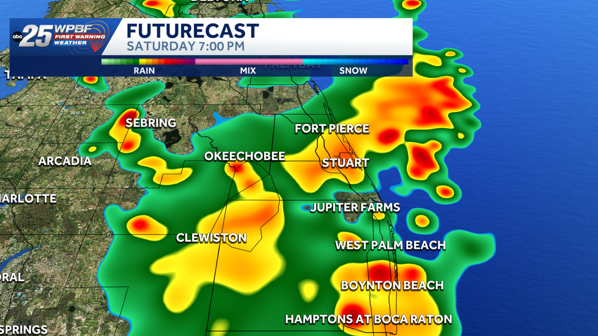
OF THE SEASON FOR THE NORTHERN HEMISPHERE. IT’S ALSO THE LONGEST DAY OF THE YEAR IN TERMS OF HOURS OF SUNSHINE. I WOULD THINK THAT’S INTERESTING THAT LIKE, WHILE WE THINK SUMMER STARTS AT ONE DAY, YOU GUYS IN THE WEATHER WORLD HAVE A WHOLE DIFFERENT CALENDAR. YEAH. JUNE 1ST IS A METEOROLOGICAL START OF SUMMER, AND IT DEFINITELY HAS BEEN FEELING VERY SUMMER, LIKE ACROSS SOUTH FLORIDA. BUT YOU KNOW, FLORIDA, WHEN DOES IT NOT FEEL VERY SUMMER LIKE FEELS LIKE TEMPERATURES THIS AFTERNOON GOING TO BE SITTING WELL INTO THE HUNDREDS. SO IT IS GOING TO BE A VERY STEAMY DAY. YOU NEED TO MAKE SURE YOU’RE DRINKING PLENTY OF WATER. MAKE SURE YOUR PETS HAVE PLENTY OF WATER, AND TRY TO AVOID STRENUOUS ACTIVITY OUTSIDE DURING THOSE PEAK HEATING HOURS. SO NOT ONLY ARE WE GOING TO BE DEALING WITH THE HEAT AND HUMIDITY, BUT ALSO SHOWER AND STORM COVERAGE OF AT LEAST 50% ACROSS OUR AREA. SO WE DO HAVE IMPACT WEATHER IN PLACE FOR OUR SATURDAY, PREDOMINANTLY IN THE AFTERNOON AND INTO THE EVENING HOURS. SO HEY, IF YOU WANTED TO GET OUTSIDE, DO IT IN THE MORNING BECAUSE THAT’S WHEN WE WILL HAVE SOME NICE CONDITIONS OUT THERE. IT’S GOING TO BE A GORGEOUS START TO OUR DAY. IF YOU DO WANT TO HEAD OUT TO THE BEACH, AND THEN BY THE TIME WE HEAD INTO THE TWO 3:00 HOUR, THAT’S WHEN WE WILL BE TRACKING SCATTERED SHOWERS AND STORMS MOVING INTO THE AREA. THAT’S WHEN YOU WANT TO BE INSIDE. AND IF YOU DO HAVE ANY PLANS FOR LATER ON TODAY, JUST MAKE SURE YOU HAVE THE RAIN GEAR HANDY. YOU WILL NOTICE FOR YOUR SUNDAY IT IS GOING TO BE ANOTHER HOT AND HUMID ONE FOR US. TEMPERATURES GOING TO BE BREAKING INTO THE LOW TO MID 90S ONCE AGAIN, AND FEELS LIKE TEMPERATURES WILL ALSO BE SITTING WELL INTO THE TRIPLE DIGITS. SO TOMORROW IS GOING TO BE ANOTHER DAY WHERE YOU NEED TO BE FLEXIBLE WITH YOUR PLANS, NOT ONLY BECAUSE OF THE HEAT AND HUMIDITY, BUT THOSE SHOWERS AND STORMS AS WELL. THE HEAT GOING TO BE STICKING WITH US OVER THE NEXT SEVEN DAYS, RAINFALL CHANCES BECOMING A BIT MORE ISOLATED AS WE LOOK AHEAD TO THE WORKWEEK. NOW FOR TODAY, AGAIN, GOING TO BE VERY STEAMY ACROSS OUR AREA. AND SO WITH THAT, WE DO HAVE A MODERATE TO MAJOR HEAT RISK. SO THAT’S WHY IT IS VERY IMPORTANT THAT YOU’RE LISTENING TO YOUR BODY, BECAUSE THOSE ARE THE AREAS MOST VULNERABLE TO HEAT ILLNESSES FOR TODAY. RIGHT NOW WE’RE AT 75 IN HOBE SOUND, 75 IN OKEECHOBEE, 75 IN VERO BEACH, AND CURRENTLY 77 IN WEST PALM. FEELS LIKE TEMPERATURES AGAIN GOING TO BE PLAYING A ROLE ONCE THE SUN RISES, BUT NOT REALLY FEELING A DIFFERENCE JUST YET. NOW HERE’S A LOOK AT YOUR DAY ON FUTURE CAST DRY START TO OUR MORNING. THEN AROUND NOON, THAT’S WHEN WE WILL BEGIN TO SEE A COUPLE OF SHOWERS POPPING UP. NOT REALLY GOING TO BE TOO MUCH IN THE WAY OF RAIN AROUND THAT TIME FRAME. AND THEN AROUND TWO 3:00, THAT’S WHEN WE WILL BEGIN TO TRACK SCATTERED SHOWERS AND STORMS ACROSS THE AREA. THAT’S GOING TO CONTINUE AS WE HEAD INTO THE DINNER HOUR AND TAKE A LOOK AT THIS PARTICULAR MODEL RUN REALLY HAS A RAMPING UP IN THE TREASURE COAST AS WE HEAD INTO THIS EVENING. SO THIS IS REALLY GOING TO BE AN EVENT FOR THE SECOND HALF OF THE DAY AFTER THE LUNCH HOUR. THAT’S WHEN WE WILL REALLY BEGIN TO SEE THOSE SCATTERED SHOWERS AND STORMS MOVING IN PREDOMINANTLY FROM THE WEST AND THEN PUSHING OFFSHORE. AS WE HEAD INTO LATE TONIGHT. SO FOR TODAY, AGAIN, BE FLEXIBLE WITH YOUR PLANS. BE WEATHER AWARE BECAUSE WE WILL HAVE SCATTERED SHOWERS AND STORMS THROU
South Florida under Impact Weather Day with heat and storms expected

Updated: 9:45 AM EDT Jun 20, 2026
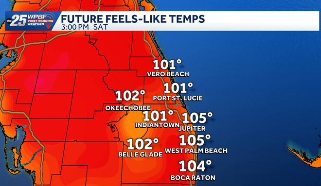
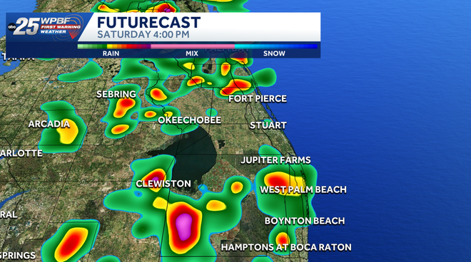
South Florida is under an Impact Weather Day for Saturday as dangerous heat and a round of afternoon and evening thunderstorms are expected across the region.Stay up to date: The latest headlines and weather from WPBF 25High temperatures will climb into the low to mid-90s, but it will feel much hotter because of the humidity. Heat index values, or “feels-like” temperatures, are expected to reach the low 100s, with some areas feeling as hot as 105 degrees during the afternoon.Residents are urged to drink plenty of water, take breaks in the shade or air conditioning, and make sure pets have access to fresh water.The first half of the day should be mostly dry, although a few isolated showers cannot be ruled out. By the afternoon, showers and thunderstorms will begin to develop, especially inland and around Lake Okeechobee.Storm coverage is expected to increase through the late afternoon and evening, with at least a 50% chance of rain across much of South Florida. Some storms could bring heavy downpours, frequent lightning and gusty winds.Forecast models show the greatest storm coverage developing after 4 p.m. and continuing into the evening, affecting parts of the Palm Beaches, Treasure Coast and inland communities. Get the latest weather updates with the WPBF 25 News app. You can download it here.
South Florida is under an Impact Weather Day for Saturday as dangerous heat and a round of afternoon and evening thunderstorms are expected across the region.
Stay up to date: The latest headlines and weather from WPBF 25
High temperatures will climb into the low to mid-90s, but it will feel much hotter because of the humidity. Heat index values, or “feels-like” temperatures, are expected to reach the low 100s, with some areas feeling as hot as 105 degrees during the afternoon.
Hearst Owned
Feel like temperature
Residents are urged to drink plenty of water, take breaks in the shade or air conditioning, and make sure pets have access to fresh water.
The first half of the day should be mostly dry, although a few isolated showers cannot be ruled out. By the afternoon, showers and thunderstorms will begin to develop, especially inland and around Lake Okeechobee.
Storm coverage is expected to increase through the late afternoon and evening, with at least a 50% chance of rain across much of South Florida. Some storms could bring heavy downpours, frequent lightning and gusty winds.
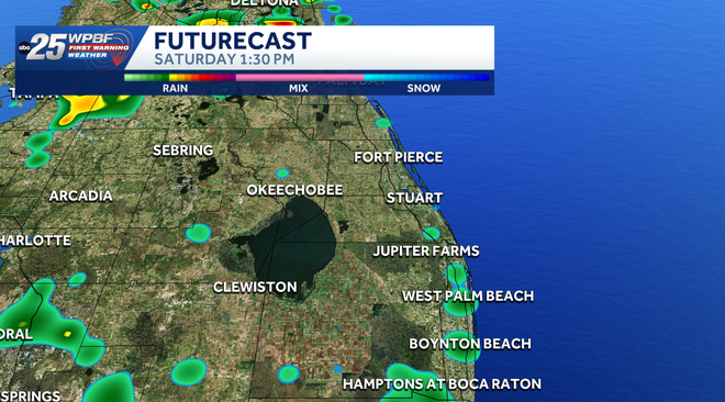
Forecast models show the greatest storm coverage developing after 4 p.m. and continuing into the evening, affecting parts of the Palm Beaches, Treasure Coast and inland communities.
Get the latest weather updates with the WPBF 25 News app. You can download it here.