
Near-record heat expected today across Central Florida
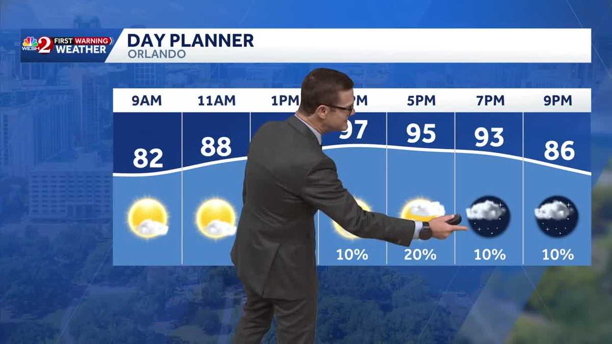
BRINGING BACK WHO KNOWS WHAT THEY’RE GOING TO BRING BACK TOO. SO ANYWAY, BEAUTIFUL THIS MORNING, IF YOU’RE HERE FROM OUT OF TOWN, YOU’RE GOING TO BRING BACK THE DESIRE FOR SOME COOLER AIR. IT IS HOT. WE’RE NOT GETTING TO RECORD HEAT TODAY. MY FORECAST TEMPERATURE 97. WE’VE DONE 98 THIS YEAR. THAT’S THE HIGHEST TEMP. AND TODAY’S RECORD SET BACK IN 1924 IS 99 DEGREES. ALL OF CENTRAL FLORIDA IS GOING TO BE IN THE BALLPARK, PARTICULARLY MELBOURNE AND EVEN LEESBURG, BUT NOT EXPECTING IT. SO WHO GETS THE RAIN OPPORTUNITIES? HERE’S LUNCHTIME. A FEW SHOWERS ON FUTURECAST AROUND MARION COUNTY, THEN A FEW POPCORN, ISOLATED SHOWERS AROUND THE METRO. THREE 4:00 AND THE BEST CHANCE FOR A FEW THUNDERSTORMS IS GOING TO BE ALONG THE I-95 CORRIDOR, BREVARD COUNTY, AND EVEN UP INTO FLAGLER SAINT JOHNS COUNTY BEFORE IT FADES OUT THROUGH ABOUT DINNER TIME. SO IT’S NOT THE RAIN. CHANCES ARE VERY HIGH AT ALL. BUT YOU CAN SEE KIND OF THESE GREEN SHADES, AREAS THAT HAVE A CHANCE TO SEE SOME RAINFALL. IF YOU LIVE IN SUMTER COUNTY, EVEN MUCH OF LAKE COUNTY, PROBABLY NOT GOING TO SEE MUCH, IF ANYTHING, IN THE WAY OF RAIN. THE BIG STORY TODAY ISN’T THE FRANKLY, IT’S THE FEELS LIKE TEMPERATURES AND THE ACTUAL TEMPERATURES PUSHING TOWARD LUNCHTIME 88, 89, 90 DEGREES, 1 P.M. IT’S 9397 DEGREES. OUR DAYTIME HIGH AND THE FEELS LIKE TEMPERATURE GETS TO 106 DEGREES. THAT’S JUST SHY OF HEAT ADVISORY CRITERIA, BUT WE’RE STILL PLENTY HOT. AND NOTICE WE’RE NOT EXACTLY TRACKING A BUNCH OF RAIN AT 10 TO 20% COVERAGE. THAT’S ALL I’VE GOT. SO TODAY IS GOING TO BE THE HOTTEST DAY OF THE LOT AT 97. THEN FOR OUR WEDNESDAY, WE START TO WORK IN MORE MOISTURE, BRINGING UP THE SHOWER OR THUNDERSTORM COVERAGE. AND WE’LL SIT IN THE MID 90S. BUT TODAY THAT UPPER 90 DEGREE READING IS DEFINITELY GOING TO BE ONE OF THOSE THINGS THAT JUST TAKES THE BREATH OUT OF YOU. SO TAKE IT EASY. IF YOU’VE GOT PLANS OUT AND ABOUT. ALL RIGHT. TOURIST DISTRICT LOOKING PRETTY GOOD THIS DARK AND EARLY TUESDAY MORNING. TEMPERATURES IN THE MID TO UPPER 70S. NOTHING ON OUR FIRST WARNING. LIVE RADAR HEADING OUT TO THE BEACHES TODAY. SEAS AND SURF RUNNING ABOUT 1 TO 2FT. WATER TEMPERATURES IN THE LOWER 80S. I MEAN, IT LOOKS LOVELY OUT THERE TODAY, 97 DEGREES. BUT LOOK AT THESE. FEELS LIKE TEMPERATURES. HOW QUICKLY THEY CLIMB. 106 IN ORLANDO FEELS LIKE 103 IN OCALA, 104 IN CLERMONT, AND EVEN ALONG THE EAST COAST BEACHES, WE’RE INTO THE 100 DEGREE READINGS. RAIN CHANCES ARE RISING THESE NEXT FEW DAYS AND THEN LOOKING AHEAD TO THE WEEKEND, WE’RE GOING TO STAY IN THE MID 90S AND KEEP THOSE SHOWERS AND THUNDERSHOWERS WITH US. SEVEN DAY FORECAST FOR OUR COASTAL COMMUNITIES. SAME IDEA. RAIN COVERAGE TODAY. RELATIVELY LOW. BREVARD COUNTY WILL GIVE YOU MORE OF A 3,040% COVERAGE. BUT NOTICE YOUR WEDNESDAY, THURSDAY, FRIDAY THAT RAIN COVERAGE DRAMATICALLY INCREASES. THAT’S GOING TO HELP TO COOL US DOWN FOR TODAY. WE’RE BEGGING FOR A COOLING SHOWER. WE’RE ALSO BEGGIN
Temperatures are expected to soar to 97 degrees on Tuesday.That is just one degree shy of the hottest temperature recorded so far this year and four degrees below the all-time June record of 101 degrees.Conditions will remain mostly dry, with only a 20% chance of scattered showers and thunderstorms.A shift in the weather pattern begins Wednesday as the heat-producing ridge weakens, allowing moisture to return to the area. Shower and thunderstorm chances are expected to increase into the 50% to 60% range through the weekend.First Warning Weather Stay with WESH 2 online and on-air for the most accurate Central Florida weather forecast.RadarSevere Weather AlertsDownload the WESH 2 News app to get the most up-to-date weather alerts. The First Warning Weather team includes First Warning Chief Meteorologist Tony Mainolfi, Eric Burris, Marquise Meda, Cam Tran and Victoria Wisniewski.
ORLANDO, Fla. —
Temperatures are expected to soar to 97 degrees on Tuesday.
That is just one degree shy of the hottest temperature recorded so far this year and four degrees below the all-time June record of 101 degrees.
Conditions will remain mostly dry, with only a 20% chance of scattered showers and thunderstorms.
A shift in the weather pattern begins Wednesday as the heat-producing ridge weakens, allowing moisture to return to the area.
Shower and thunderstorm chances are expected to increase into the 50% to 60% range through the weekend.
First Warning Weather
Stay with WESH 2 online and on-air for the most accurate Central Florida weather forecast.
Download the WESH 2 News app to get the most up-to-date weather alerts.
The First Warning Weather team includes First Warning Chief Meteorologist Tony Mainolfi, Eric Burris, Marquise Meda, Cam Tran and Victoria Wisniewski.