
Impact Weather: Damaging winds, downpours and hail possible in Central Florida
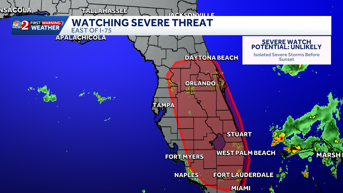
ARKANSAS. ALL AMERICA. 250 STORIES YOU CAN FIND ON WESH.COM. LET’S TALK ABOUT THE WEATHER NOW THIS AFTERNOON. MARQUISE JOINING US ON MARQUISE THINKING WE MIGHT EVEN HAVE SOME IMPACT WEATHER LATER ON TODAY. YEAH, THE SPC JUST ISSUED THEIR OUTLOOK AND THEY’RE CALLING FOR A MARGINAL THREAT. IT’S A ONE OUT OF FIVE IN WHICH THE PRIMARY IMPACTS WILL BE THE RAIN SHOWERS. AND OF COURSE, THE STRONG AND GUSTY WINDS. WE HAVE A LOT OF ENERGY IN THE ATMOSPHERE TODAY DUE TO HOW HOT AND HUMID IT ALREADY IS. YOU COMBINE THAT WITH SEA BREEZES HERE IN CENTRAL FLORIDA, AND WE’VE GOT A RECIPE FOR A SEVERE STORM OR TWO, LIKELY JUST EAST OF THE I-75 CORE. I DO BELIEVE THE HEAVIEST RAIN THAT WE’LL SEE, THOUGH, WILL BE ACROSS I-95 THROUGH OUR COASTAL COMMUNITIES. SO WE’RE LOOKING AT HEAVY RAINS, GUSTY WINDS, AND WE CAN’T RULE OUT THE CHANCE FOR HAIL OR A TORNADIC IMPACT. BUT I DO BELIEVE THAT THE RAIN THREAT IN THE WINDS WILL BE HIGH ON OUR LIST. AND THAT’S GOING TO BE THE CASE ALL THROUGHOUT THE WORKWEEK AND INTO YOUR WEEKEND TO NOTICE THAT YOUR RAIN CHANCES HOVER BETWEEN 40 AND 50% HERE IN CENTRAL FLORIDA. SO JUST TO REITERATE, TODAY IS AN IMPACT DAY. IMPACT WEATHER EXPECTED THROUGHOUT THE AFTERNOON AND INTO THE EARLY EVENING. AND THEN ON THURSDAY AND FRIDAY AS WE CONTINUE THROUGHOUT THE WORKWEEK, MORE OF THE SAME COMING YOUR WAY AS TEMPERATURES DON’T REALLY BUDGE THIS WEEKEND, WE MIGHT BE A TOUCH WARMER UPPER 90S COMING YOUR WAY ON SUNDAY. BUT AS WE HEAD INTO THE WORK WEEK, MONDAY AND TUESDAY, NOW WE SEE A CHANCE TO COOL DOWN JUST A BIT. ONE OF THE REASONS WHY IS THAT WE’LL SEE THE WINDS BEGIN TO SHIFT. SO START OFF THE WORKWEEK. WE’VE GOT THIS WESTERLY FLOW MEETING UP WITH ONE FROM THE EAST, COURTESY OF THAT TROUGH DESCENDING THROUGHOUT THE SOUTH. BUT ONCE THIS HIGH PRESSURE SYSTEM DISSIPATES, IT’S THIS STRICT EASTERLY FLOW THAT WE’LL SEE. THAT’S OF COURSE GOING TO INCREASE YOUR CHANCE FOR ANY RIP CURRENTS. THREATS ACROSS ATLANTIC COMMUNITIES, BUT ALSO THAT DEEP EASTERLY MOISTURE COULD POTENTIALLY GET THE RAIN HERE EARLIER, KEEPING OUR TEMPERATURES JUST A TOUCH COOLER OUT THE DOOR. IN PORT CANAVERAL, THOUGH, WE SEE MOSTLY CLOUDY SKIES WITH A FEELS LIKE TEMPERATURE OF 105 DEGREES. YOU’RE IN THE LOWER 90S, HOWEVER, AND FURTHER INLAND, WE DO HAVE A COUPLE HUNDREDS ON THE BOARD FOR. FEELS LIKE CONDITIONS LIKE WILDWOOD KISSIMMEE 100 ON THE DOT BITHLO AND SAINT CLOUD IN BETWEEN THAT 105 TO 110 DEGREE MARK. AND WITH THIS FRONTAL BOUNDARY ACTUALLY PUSHING TOWARDS THE NORTH, WE HAVE AN OPPORTUNITY FOR SOME RELIEF FROM THE HEAT ANYTIME SOON. RAIN CHANCES ACROSS THE COAST YOU SEE THOSE BUILDING AT FOUR AND 5:00 IN DAYTONA BEACH. HIGH TEMPERATURES UP THAT DIRECTION WILL BE BACK IN THE LOW 90S MID 90S INLAND AS THE SHOWERS AND STORMS START TO EXPAND THROUGHOUT THE AFTERNOON. TAKE A LOOK AT THE COAST THOUGH. WE HAVE THIS WESTERLY FLOW PUSHING THE MOISTURE ACROSS OUR COASTAL COMMUNITIES. SO HERE’S THAT CHANCE FOR RAIN BALLOONING IN VOLUSIA COUNTY ACROSS DAYTONA AND NEW SMYRNA. BUT NOTICE, BY 7:00, SHOWERS ARE OFFSHORE AND WE’RE TRENDING QUIETER ENTERING THE EVENING. TAKE A QUICK SECOND TO TRACK THE TROPICS. NOTHING TO SEE HERE AS WE’RE TRENDING QUITE QUIET FOR THE NEXT SEVEN DAYS. BUT THROUGH THE THROUGHOUT THE REST OF THE MONTH OF JUNE, WE’LL KEEP OUR ATTENTION ON THE GULF COAST. THAT’S WHERE CLIMATOLOGY SHOWS US THE MOST FORMATIONS TO OCCUR. BUT WITH THIS RIDGE OF HIGH PRESSURE GROWING THIS WEEKEND AND INTO THE WORK WEEK, WE’LL SEE THOSE TEMPERATURES MOVING IN THE SAME DIRECTION AND MITIGATING ANY CHANCE FOR TROPICAL FORMATIONS THERE. SO WEDNESDAY STILL TODAY IMPACT WEATHER MOVING ACROSS T
Impact Weather: Damaging winds, downpours and hail possible in Central Florida

Updated: 2:02 PM EDT Jun 24, 2026
Heat will continue to build across Central Florida on Wednesday, with the potential for a few strong to severe storms later this afternoon and evening.As the sea breezes move inland, a few pulse-type severe storms could develop. The main threats will be locally heavy rain and gusty winds, though some hail is also possible. The tornado risk remains low, but it is not zero.Impact Weather is expected through 9 p.m.Active alerts:Severe thunderstorm warning issued for Orange, Osceola and Brevard counties until 2:45 p.m.Storm coverage is expected to stay high again Thursday before decreasing Friday and into the weekend. High temperatures will climb to around 95 degrees, with feels-like temperatures reaching the triple digits into next week.>> What is Impact Weather?Impact Weather suggests weather conditions could be disruptive or a nuisance for travel and day-to-day activities.First Warning Weather Stay with WESH 2 online and on-air for the most accurate Central Florida weather forecast.RadarSevere Weather AlertsDownload the WESH 2 News app to get the most up-to-date weather alerts. The First Warning Weather team includes First Warning Chief Meteorologist Tony Mainolfi, Eric Burris, Marquise Meda, Cam Tran and Victoria Wisniewski.
ORLANDO, Fla. —
Heat will continue to build across Central Florida on Wednesday, with the potential for a few strong to severe storms later this afternoon and evening.
As the sea breezes move inland, a few pulse-type severe storms could develop.
The main threats will be locally heavy rain and gusty winds, though some hail is also possible.
The tornado risk remains low, but it is not zero.
Impact Weather is expected through 9 p.m.
Storm coverage is expected to stay high again Thursday before decreasing Friday and into the weekend.
High temperatures will climb to around 95 degrees, with feels-like temperatures reaching the triple digits into next week.
This content is imported from Twitter.
You may be able to find the same content in another format, or you may be able to find more information, at their web site.
We’re looking at a higher coverage of storms today with the focus across the interior of the #Florida Peninsula. The evening commute may be impacted by these storms. A few areas could pick up a quick 1-3″ of rain in those heavier pockets. Stay with #weshwx for updates. pic.twitter.com/cY3EVAwaSB
— Tony Mainolfi (@TMainolfiWESH) June 24, 2026
>> What is Impact Weather?
Impact Weather suggests weather conditions could be disruptive or a nuisance for travel and day-to-day activities.
First Warning Weather
Stay with WESH 2 online and on-air for the most accurate Central Florida weather forecast.
Download the WESH 2 News app to get the most up-to-date weather alerts.
The First Warning Weather team includes First Warning Chief Meteorologist Tony Mainolfi, Eric Burris, Marquise Meda, Cam Tran and Victoria Wisniewski.