
Hot temps, stormy pattern holds through weekend across Central Florida
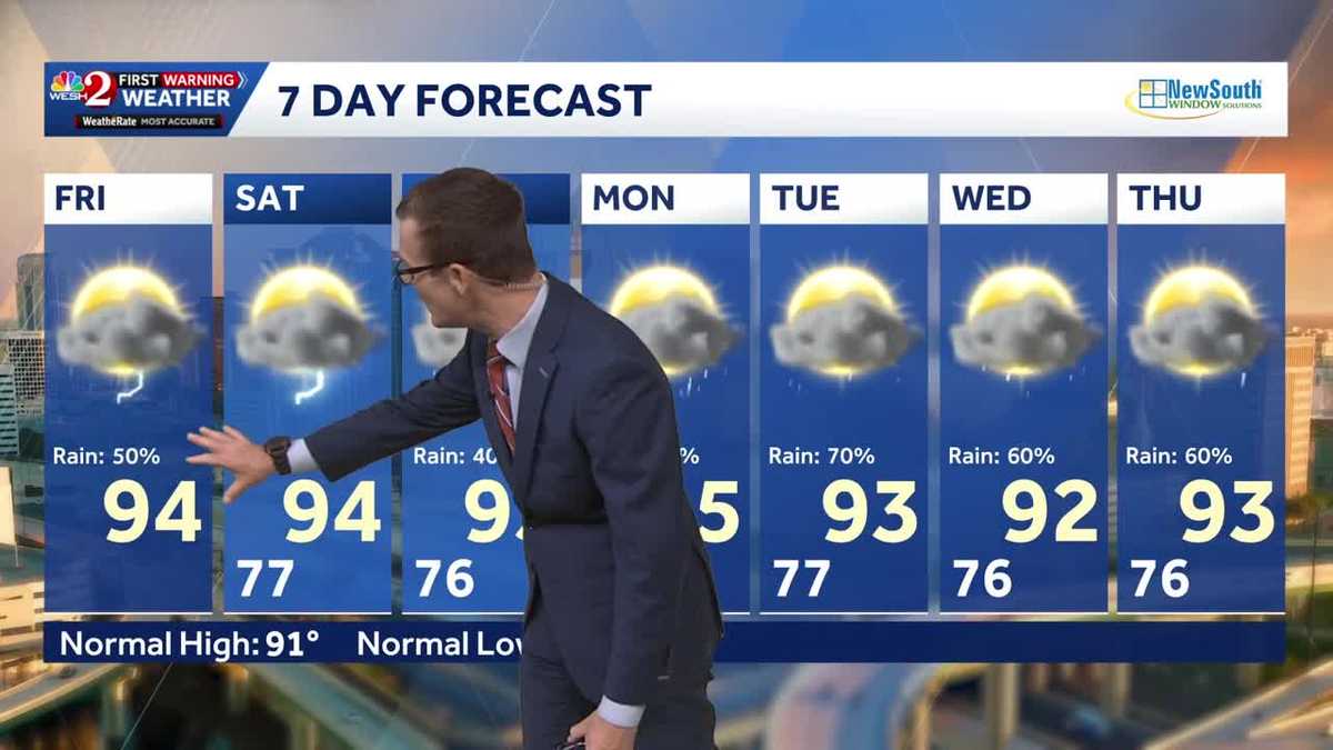
What about our forecast today? Not air conditioned. Came in this morning. I do every day. I look up at the tower because I remember that morning we walked in. I was thinking, oh boy, it’s gonna be another hot 1. 80 degrees, it said. That was at 3:30 this morning. So you were late is what you’re saying publicly. Maybe 3:29. OK, I’m just kidding. No, none of us are. But listen, it’s warm outside. All of that helping to provide moisture for showers and storms later. And the reality is we’ve got our normal setup for this time of year, storms popping up in the afternoon, but the bigger weather story. The bigger change, if you will, is going to be early next week as *** storm system kind of bubbles up over top of us and brings us even more rainfall. So let’s just fast forward, OK, this is Monday, old front north of us, rain chance really growing because that front kind of shoving that moisture in. Then looking ahead to Tuesday and Wednesday, area of low pressure pulls away from that. And eventually works over toward Louisiana and it’s going to be in that window there. Some of the models are hinting there could be some sort of low-end tropical development if it happens, *** depression, maybe *** low-end storm. These things happen. It’s not *** big impactor typically other than just big rain, but look at the water vapor. This is the moisture content in the atmosphere. You see all that green. Yeah, lots of that moisture, *** little piece of energy breaks off and then kind of works over toward Louisiana. So we’ll be tracking it, but with social media the way that it is today in the weather sphere, if you will, I just want to make sure you know this is not any concern whatsoever, whether or not anything tropical gets going. Either way though, look at the rain chance normal 40, 50% coverage through the weekend and then into early next week that rain chance rises for. Today, lunchtime is fine. We start the sea breezes by 2:00 p.m. and then 456 o’clock. That’s when we get those thunderstorms popping on up, continuing through 89 o’clock. So your dinner plans may be *** little more questionable today because of that later start. So we see the storm coverage continuing through the later time frame, 94 degrees, our high temperature. Looking ahead to the weekend, normal storm coverage if you’re wanting. To head to the beaches this weekend. Happy to say surf running 1 to 2 and water temperatures into the lower range of the 80s. Air temperature on the beach, sand hanging out in the mid to even upper 80s. So it feels comfortable out there, no doubt about it. 7 day forecast showing normal stuff this weekend, rising rain chance into your Monday, Tuesday, Wednesday. Other than that, smooth sailing through that 7 day forecast. We’ll be here watching it, keeping you up to date, Megan Mackey.
Hot temps, stormy pattern holds through weekend across Central Florida

Updated: 6:02 AM EDT Jun 26, 2026
The pattern of hot temperatures and feisty storms continues today, with highs reaching the mid 90s and roughly 50% coverage of showers and thunderstorms.This same pattern continues through the weekend, but early next week things get interesting.Sunday into Monday, an old front dies north of us, bubbling up perhaps an area of low pressure. As that happens, our rain chances start going up even more, and some models hint that a weak, sloppy tropical low may form.No matter what actually happens, for now the rain coverage really goes up. As for the tropical parts, let’s just wait and see for now. First Warning Weather Stay with WESH 2 online and on-air for the most accurate Central Florida weather forecast.RadarSevere Weather AlertsDownload the WESH 2 News app to get the most up-to-date weather alerts. The First Warning Weather team includes First Warning Chief Meteorologist Tony Mainolfi, Eric Burris, Marquise Meda, Cam Tran and Victoria Wisniewski.
ORLANDO, Fla. —
The pattern of hot temperatures and feisty storms continues today, with highs reaching the mid 90s and roughly 50% coverage of showers and thunderstorms.
This same pattern continues through the weekend, but early next week things get interesting.
Sunday into Monday, an old front dies north of us, bubbling up perhaps an area of low pressure. As that happens, our rain chances start going up even more, and some models hint that a weak, sloppy tropical low may form.
No matter what actually happens, for now the rain coverage really goes up. As for the tropical parts, let’s just wait and see for now.
First Warning Weather
Stay with WESH 2 online and on-air for the most accurate Central Florida weather forecast.
Download the WESH 2 News app to get the most up-to-date weather alerts.
The First Warning Weather team includes First Warning Chief Meteorologist Tony Mainolfi, Eric Burris, Marquise Meda, Cam Tran and Victoria Wisniewski.