
Flood Advisories and Severe Storms Sweep Through Central Florida | New Tropical Disturbance off of the Carolinas
Flood Advisories and Severe Storms Sweep Through Central Florida | New Tropical Disturbance off of the Carolinas
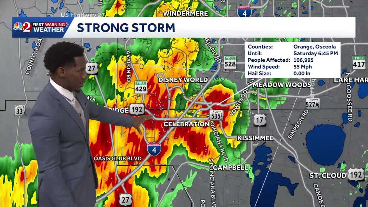
The International also had *** ground stop *** little bit earlier because of these storms. These are coming down *** little bit for some of us, Marquis, but you’re also watching the tropics. Yeah, we’re watching the rain currently begin to start to dissipate, right? But as we head towards 4th of July, we could have *** disturbance just off our coastline that may impact your chance for some wet weather. Ultimately, right now it’s only *** 20% chance for further development down the line, but we are anticipating *** broad area of low pressure just off the coast of the Carolinas developing. As we kick off the work week and with the frontal boundary swinging towards the south, by the time that low pressure system does get towards our direction, it does mean that we have an increased chance for some wet weather heading our direction. So this is gonna drift towards the south and the west. We see that, uh, wind influence as we head into Wednesday and an uptick in your rain chances as well, hovering around 70% on Tuesday. So some very moist air heading our direction. And by the time the week. It is said and done between now and July 4th, the further north you go, the better your chance for rain is going to be. We could see pockets of rain anywhere between 3 and 5 total inches, but across the panhandle, that becomes *** little bit more widespread where that front does begin to stall out. Keep in mind they need the rain more than us, as it’s still an extreme drought surrounding the I-10 quarter, severe though once you move west of I-4. So we all need the showers. Some of us got our fair share today. As we head towards I-4 right now, still ongoing lightning strikes and *** strong storm that we’ll be monitoring across Orange and Osceola County through 6:45. You see all the lightning across Celebration just south of the tourist district along the I-4 corridor. Max winds are about 55 MPH, but as we zoom on in, we’re also monitoring your chance for some hail towards Celebration. Hail is anywhere between 0.5 inch and 3/4 of an inch in diameter across US 192 there heading further. South, light showers across Polk City, Haines City as well, but it does look like those showers and storms are pushing south and west into Polk County, dissipating across Ocoee. Also Lockhart, light rain in your direction. These showers in Salt Springs will be coming to an end momentarily, but we’ve seen about 2.5 to 3 inches of rain out in that direction. As for tomorrow, with high pressure moving into the Gulf, this is *** weak system. It’s gonna keep us *** little bit drier to finish off the weekend as opposed. To what we started it with today with those severe showers and storms. So as we head outside to Lake County here in Tavares, temperatures are back in the upper 70s, just *** hop skip and *** jump towards Leesburg, but ultimately we’ve all cooled down courtesy of the showers today. But they won’t stick around forever. Notice what we have across the I-4 quarter. By 8 o’clock will be likely coming to an end. We’ll see those cloudy skies for *** moment, but over the course of your evening we’ll transition to partly cloudy and mostly clear skies once the rain. Comes to an end. Temperature wise you’ll be trending warm tonight and muggy anywhere between the low 70s and the low 80s. Pool forecast for tomorrow not looking too great as showers and storms will hang around in the afternoon. *** bit of *** later start, and as you head further south across our sunshine state, that’s where the better chance for showers is going to lie. So we’ll pick up that chance in the afternoon, but that’s after temperatures hit the mid 90s right here inside the city. Beautiful, cooling with the rain. It’s not going to last forever. By 9:30 we’re quiet again. And cooling heading into the evening, but we’ll warm back up as we approach 4th of July. We’ll see that increase in temperatures being above our seasonal average. I wanna pay close attention to this water vapor here. This is gonna show the moisture that we start off the work week with drier on Thursday and Friday, but as. As we head into the weekend, we could see *** little bit more wet weather next Saturday, which happens to be July 4th. So as we take *** look at your 7 day certified most accurate forecast, be prepared for warmer temperatures on Monday, more rain chances on Tuesday, and consistent chances for showers as we head into your next weekend.
Flood Advisories and Severe Storms Sweep Through Central Florida | New Tropical Disturbance off of the Carolinas
Flood Advisories and Severe Storms Sweep Through Central Florida | New Tropical Disturbance off of the Carolinas

Updated: 10:04 PM EDT Jun 27, 2026
Flood Advisories and Severe Storms Sweep Through Central Florida | New Tropical Disturbance off of the Carolinas
Flood Advisories and Severe Storms Sweep Through Central Florida | New Tropical Disturbance off of the Carolinas