
Impact Weather: Temperatures climbing above 100 degrees across Central Florida
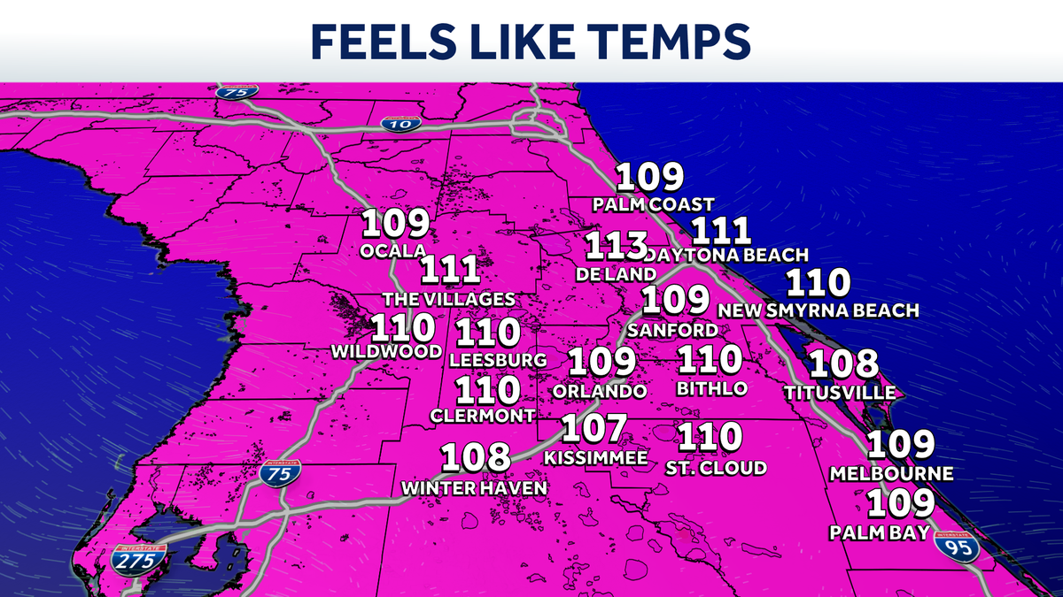
I WAS APPARENTLY NOT IN THE SAME KEY AS YOU. YOU KNOW WHAT IS IN KEY, THOUGH? YEAH. THE TEMPERATURES. AND FEELS LIKE THEY ARE LINING UP. AND WE’RE NOT LOVING THIS. IT IS SO WARM AND MUGGY. WE HAVE TO CALL FOR IMPACT WEATHER TODAY BECAUSE THIS DOES GET INTO, FRANKLY, DANGEROUS TERRITORY. 96 DEGREES IS OUR FORECAST FOR TODAY. BUT WITH ALL OF THE HUMIDITY THAT’S IN PLAY, IT FEELS LIKE 109 IN ORLANDO FEELS LIKE 111 IN THE VILLAGES. FEELS LIKE 108 IN TITUSVILLE. YEAH. THEN OF COURSE, THE QUESTION IS LIKE, WHEN DO WE GET THE RAINS MOVING IN? TAKE A LOOK. ALL HERE’S FUTURECAST ONE 2:00. ALREADY STARTING TO SPARK UP SHOWERS AND THUNDERSHOWERS. GOING MORE WIDESPREAD AROUND TOWN THROUGH 4:00. AND THEN FIVE, SIX, 7:00. IT TRIES TO WORK OVER TOWARD THE BEACHES, BUT KIND OF FADES AS IT DOES SO. SO THAT’S A LOOK AT TODAY. THEN FOR TOMORROW, WE ACTUALLY INCREASE OUR COVERAGE OF RAIN A LITTLE BIT. AN AREA OF LOW PRESSURE STARTS TO FORM OFF THE EAST COAST, AND IT’S JUST THROWING MORE MOISTURE. OUR DIRECTION BY WEDNESDAY, RAIN COVERAGE DROPS OFF A LITTLE BIT BECAUSE THAT LOW IS GETTING CLOSER TO US. AND THEN FOR THURSDAY AND FRIDAY, WE ESSENTIALLY START TO WATCH THAT AREA OF LOW PRESSURE BACK OVER TOP OF US. AND THAT’S GOING TO LEAD TO A HIGHER COVERAGE OF RAIN. SO THAT’S KIND OF SITTING WHERE WE’RE AT NOW IN TERMS OF TODAY, 109 IS GOING TO BE THE FEELS LIKE TEMPERATURE. THAT’S WHAT TRIGGERS THE HEAT ADVISORY. NOTICE. WE’RE STILL GOING TO BE PLENTY WARM FEELING OVER THE NEXT FEW DAYS. 108, THOUGH, IS THE MONIKER. ONCE WE GET ABOVE 108, WE HAVE TO GET THAT HEAT ADVISORY POSTED. OF COURSE, TO THE RAIN COVERAGE. IT’S GOING TO REALLY BE CENTERED ACROSS THE CENTER OF THE PENINSULA. TODAY, AS I SHOWED YOU ON OUR FUTURECAST MODEL, LOOKING OVER TO THE BEACHES TODAY, RAIN COVERAGE A LITTLE BIT LOWER, SO NOT A BAD ONE SEASON SURF RUNNING ABOUT 1 TO 2FT. WATER TEMPERATURES ARE HANGING OUT IN THE LOWER 80S. IT DOES LOOK LIKE IT’S GOING TO BE A FANTASTIC FORECAST OUTSIDE THIS MORNING. SPEAKING OF THE BEACHES, WE TAKE A LIVE LOOK OVER TO DAYTONA BEACH, WHERE THE HALIFAX IS QUIET. IT LOOKS WONDERFUL, BUT IT IS WARM AND MUGGY 78 THERE. NOW IT’S 79 IN ORLANDO, 80 DEGREES FOR US IN LEESBURG. NOTHING TO SEE ON OUR FIRST WARNING LIVE RADAR. SO WE LOOK TO THE TEMPERATURES AND AGAIN, FEELS LIKE 109 ACTUAL READINGS SITTING AT 96 IN ORLANDO. IT’S ALL ABOUT THAT MUGGINESS RIGHT, 97 IN THE VILLAGES, 98 DEGREES IN DELAND FORECAST SHOWING THAT AREA OF LOW PRESSURE DOING ITS THING, BRINGING US ALL THE MOISTURE. NOW, LOOKING AHEAD TO THE LATE WEEK, OF COURSE, WE’VE GOT A HOLIDAY WEEKEND HERE. FRIDAY STARTS OFF THAT JULY 4TH HOLIDAY SATURDAY INTO SUNDAY. RAIN COVERAGE IS GOING TO BE FAIRLY HIGH. LOOK AT THAT 7,060%. SO LOOKING AT FIREWORKS FESTIVITIES, WE’RE DEFINITELY GOING TO HAVE TO NAVIGATE THE RAINS. BUT OF COURSE, AS WE GET CLOSER
Impact Weather: Temperatures climbing above 100 degrees across Central Florida

Updated: 6:34 AM EDT Jun 29, 2026
A heat wave is expected to grip Central Florida on Monday. Residents should prepare for dangerous heat as temperatures climb to around 96 degrees, with heat index values expected to reach as high as 109 degrees.Heat advisories are in effect for most of the area. The combination of high temperatures and oppressive humidity will create hazardous conditions during the afternoon.Impact weather is expected from noon until 7 p.m. due to the dangerous heat.Relief is expected later in the day as scattered thunderstorms develop. Storm coverage is forecast at around 60% on Monday, providing cooling rainfall for many locations.>> What is Impact Weather?Impact Weather suggests weather conditions could be disruptive or a nuisance for travel and day-to-day activities.Looking aheadStorm chances are expected to increase on Tuesday, bringing more widespread coverage across the area.First Warning Weather Stay with WESH 2 online and on-air for the most accurate Central Florida weather forecast.RadarSevere Weather AlertsDownload the WESH 2 News app to get the most up-to-date weather alerts. The First Warning Weather team includes First Warning Chief Meteorologist Tony Mainolfi, Eric Burris, Marquise Meda, Cam Tran and Victoria Wisniewski.
A heat wave is expected to grip Central Florida on Monday.
Residents should prepare for dangerous heat as temperatures climb to around 96 degrees, with heat index values expected to reach as high as 109 degrees.
Heat advisories are in effect for most of the area.
The combination of high temperatures and oppressive humidity will create hazardous conditions during the afternoon.
Impact weather is expected from noon until 7 p.m. due to the dangerous heat.
Relief is expected later in the day as scattered thunderstorms develop.
Storm coverage is forecast at around 60% on Monday, providing cooling rainfall for many locations.
This content is imported from Twitter.
You may be able to find the same content in another format, or you may be able to find more information, at their web site.
Heat Advisory is in effect through 7 PM for most of Central Florida, with heat index values climbing to around 109 degrees this afternoon.
The combo of heat and humidity can really take a toll today. Just something to be aware of as you head into your afternoon. pic.twitter.com/l272T2J8hF
— Eric Burris (@EricBurrisWX) June 29, 2026
>> What is Impact Weather?
Impact Weather suggests weather conditions could be disruptive or a nuisance for travel and day-to-day activities.
Looking ahead
Storm chances are expected to increase on Tuesday, bringing more widespread coverage across the area.
First Warning Weather
Stay with WESH 2 online and on-air for the most accurate Central Florida weather forecast.
Download the WESH 2 News app to get the most up-to-date weather alerts.
The First Warning Weather team includes First Warning Chief Meteorologist Tony Mainolfi, Eric Burris, Marquise Meda, Cam Tran and Victoria Wisniewski.