
Chilly morning in Central Florida gives way to warm afternoon
THEN BY LATE THIS WEEKEND THAT WILL CHANGE AROUND. LET’S TAKE YOU OUTSIDE THIS MORNING. IT IS CHILLY 47 DEGREES IN ROCK SPRINGS AND NORTH APOPKA. IT’S CHILLY UP THAT WAY. THEN WE GET OVER TO THE SOUTH SIDE. IT’S 56 LAKE BUTLER 55 OVER BY GRAND CYPRESS. I DRIVE, WAKING UP TO 53. IN THE TOURIST DISTRICT, 58 IN DOWNTOWN ORLANDO AND 57 OVER AT THE UNIVERSITY OF CENTRAL FLORIDA FOR LAKE COUNTY. IT’S 48 FROM OKAHUMPKA BACK OVER TO 49 IN LADY LAKE, IT’S 49 ASTATULA 57 IN CLERMONT. AGAIN, THAT INFLUENCE OF LAKE APOPKA REALLY PLAYING IN. BUT FOR US HERE IN MARION COUNTY, TAKE A LOOK AT THESE TEMPERATURES. 42 AT THE AIRPORT IN OCALA, 43 DOWNTOWN AND 43 IN BELLEVIEW. SO IT’S A CHILLY START, NO DOUBT ABOUT IT. 40S, 50 AROUND COOLER THAN YESTERDAY, NOTICEABLY COOLER THAN YESTERDAY. SO THE BUS STOP FORECAST DOES NEED A JACKET. OKAY, RIDE HOME WILL BE GOOD TO SHED IT. IT’S GOING TO BE BEAUTIFUL SUNSHINE THAT WILL ALLOW TEMPERATURES TO CLIMB. BUT FOR THIS MORNING YOU DEFINITELY WANT IT. AND THIS MORNING IS THE COLDEST OF THE WEEK. THEN WE START WATCHING THIS TREND OF WARMING AFTERNOONS THE NEXT COUPLE OF DAYS. AND AS A MATTER OF FACT, RIGHT THROUGH THE WEEKEND, TAKING A LOOK AT THE WEEKEND FORECAST, LOOK AT OUR SATURDAY. I KNOW IT’S EARLY, I DON’T CARE. WE CAN STILL LOOK AHEAD 85 DEGREES ON SATURDAY. ON SUNDAY IT’S 86 AND WHILE SATURDAY LOOKS BEAUTIFUL, BRIGHT, SUNNY, WE START TO SEE SOME OF THE DARKER SKIES THERE ON SUNDAY BECAUSE OUR NEXT STORM SYSTEM STARTS WORKING OUR DIRECTION. HIGH PRESSURE IN CONTROL. BUT BY SUNDAY, COLD FRONT STARTS WORKING. OUR DIRECTION WILL BRING IN SHOWERS, POTENTIALLY EVEN THUNDERSHOWERS FOR OUR SUNDAY INTO OUR MONDAY. BUT AFTERWARD, LOOK AT OUR DAYTIME HIGHS ON TUESDAY, NOVEMBER 11TH. THIS IS VETERANS DAY 68 FOR A HIGH ACCORDING TO THE GFS, AT LEAST 68 FOR A HIGH IN ORLANDO, 65 IN THE VILLAGES, 64, DAYTONA BEACH 69. IN MELBOURNE, THOSE ARE DAYTIME HIGHS. SO JUST TO LET YOU KNOW, WHILE YES, OUR TEMPERATURES ARE WARMING THE NEXT COUPLE OF DAYS, BY NEXT WEEK THAT WILL BE CHANGING. ALL RIGHT. OUTSIDE WE GO. AND A LIVE LOOK OVER TOWARD SPACESHIP EARTH. IT IS A BEAUTIFUL START. HIGHS TODAY. UPPER 70S IN OUR NORTHERN SPOTS. LOWER 80S FOR THE METRO. IT IS DEFINITELY A LITTLE WARMER THAN YESTERDAY AFTERNOON AND THAT TREND CONTINUES. A SPRINKLE OR TWO COMING IN OFF THE OCEAN ON FRIDAY. SATURDAY. BEAUTIFUL. AND THEN SUNDAY INTO MONDAY. THOSE RAIN CHANCES ARE RISING AS THAT NEXT STORM SYSTEM APPROACHES. COLD FRONT MOVES OUR DIRECTION LATE THIS WEEKEND.
Chilly morning in Central Florida gives way to warm afternoon

Updated: 5:56 AM EST Nov 4, 2025
Cooler temperatures have returned this morning, with readings in the 40s and 50s, making it a day for jackets. After this morning, a warming trend will begin, with this afternoon expected to be warmer than yesterday. The trend is expected to continue through the weekend, with temperatures forecasted to reach the mid-80s.First Warning Weather Stay with WESH 2 online and on-air for the most accurate Central Florida weather forecast.RadarSevere Weather AlertsDownload the WESH 2 News app to get the most up-to-date weather alerts. The First Warning Weather team includes First Warning Chief Meteorologist Tony Mainolfi, Eric Burris, Marquise Meda and Cam Tran.
ORLANDO, Fla. —
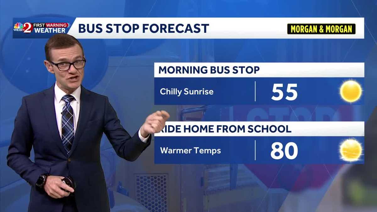
Cooler temperatures have returned this morning, with readings in the 40s and 50s, making it a day for jackets.
After this morning, a warming trend will begin, with this afternoon expected to be warmer than yesterday.
The trend is expected to continue through the weekend, with temperatures forecasted to reach the mid-80s.
First Warning Weather
Stay with WESH 2 online and on-air for the most accurate Central Florida weather forecast.
Download the WESH 2 News app to get the most up-to-date weather alerts.
The First Warning Weather team includes First Warning Chief Meteorologist Tony Mainolfi, Eric Burris, Marquise Meda and Cam Tran.