
Heavy rain, lightning, and gusty winds expected July 4 weekend in South Florida
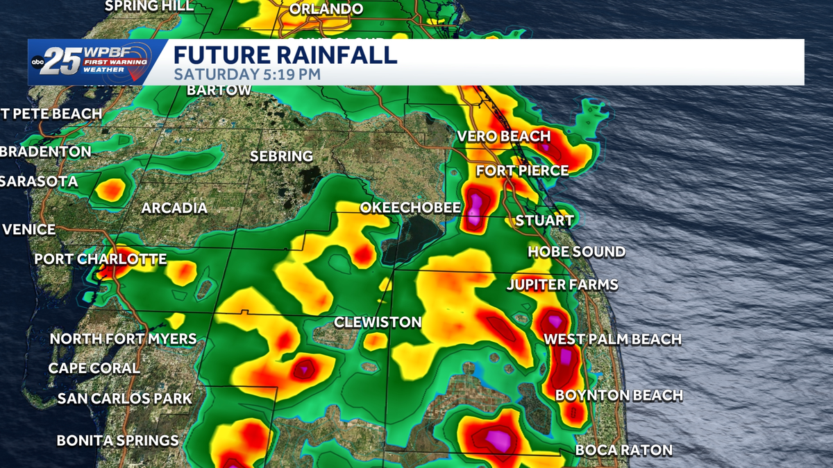
IS GETTING BETTER NIKKI, BUT IT IS STILL THERE. YEAH, UNFORTUNATELY WE STILL HAVE DROUGHT AND WE DID SEE A LITTLE BIT OF IT CREEP BACK IN WITH YESTERDAY’S UPDATE. WE DID SEE SEVERE DROUGHT RETURN TO FAR INTERIOR SECTIONS OF PALM BEACH COUNTY. SO IT’S STILL VERY DRY OUT THERE. SO YOU NEED TO BE EXTREMELY CAREFUL WITH THOSE FIREWORKS BECAUSE FIRES CAN START AND SPREAD VERY EASILY UNDER THESE CONDITIONS. NOW, THE GOOD NEWS IS WE DO HAVE PLENTY OF RAINFALL ON THE WAY OVER THE COMING DAYS. 50% COVERAGE OF SHOWERS AND STORMS FOR TODAY. THAT’S WHY I’M CALLING FOR IMPACT WEATHER, AS WELL AS THE FACT THAT WE WILL HAVE SOME STRONGER STORMS IN THE FORECAST. NOT SEVERE, JUST BELOW THAT SEVERE THRESHOLD, BUT JUST MAKE SURE YOUR WEATHER AWARE. AND THEN AS WE LOOK AHEAD TO 4TH OF JULY, ALL EYES ON THE FORECAST AS WE DO HAVE 40% CHANCE OF SHOWERS AND STORMS. YOU WILL NOTICE THAT COVERAGE IS GOING TO BEGIN TO PICK UP AS WE HEAD INTO THE LUNCH HOUR. AND THEN AS WE HEAD INTO THE AFTERNOON, WE’RE STILL GOING TO BE TRACKING SOME SCATTERED ACTIVITY. BUT THE GOOD NEWS IS, HERE’S A LOOK AROUND 6:00. SO STILL DAYLIGHT, NOT DEALING WITH THOSE FIREWORKS JUST YET. AND THAT’S WHEN WE’RE REALLY GOING TO BE SEEING OUR BEST COVERAGE. BUT AFTER THE SUN SETS, YOU WILL NOTICE HOW IT IS GOING TO BECOME A BIT MORE SPOTTY IN NATURE. SO I DO THINK WE WILL HAVE THE OPPORTUNITY FOR THOSE FIREWORK SHOWS AS WE HEAD INTO THOSE EVENING HOURS. BUT THROUGHOUT THE HOLIDAY WEEKEND, WE WILL BE DEALING WITH THOSE SHOWERS AND STORMS AND EVEN INTO THE UPCOMING WORKWEEK. WE WILL HAVE A CHANCE FOR RAINFALL. SO WHEN ALL IS SAID AND DONE OVER THE NEXT SEVEN DAYS, WE COULD PICK UP SOME DECENT RAINFALL ACCUMULATIONS. I THINK SOME SPOTS INLAND COULD GET CLOSE TO ABOUT THREE FOUR INCHES OVER THE NEXT WEEK, SO THAT IS SOME GOOD NEWS WHEN IT COMES TO OUR DROUGHT CONDITIONS. AT THE MOMENT, RADAR IS FAIRLY QUIET. JUST SOME SPOTTY SHOWERS OFFSHORE. OUR CHANCES FOR RAINFALL TODAY WILL BE PICKING UP AS WE HEAD INTO THOSE AFTERNOON HOURS. RIGHT NOW, WE’RE AT 81 DEGREES IN WEST PALM, BUT FEELING MORE LIKE 86 BECAUSE THAT HUMIDITY IS GOING TO BE PLAYING A ROLE IN OUR TEMPERATURES ONCE AGAIN FOR TODAY. 76 IN PORT SAINT LUCIE, FEELING MORE LIKE THE MID 70S AS WELL. SO THE REST OF THE MORNING, NICE AND DRY HERE IN SOUTH FLORIDA. AND THEN AS WE HEAD INTO THE AFTERNOON, WE WILL BEGIN TO SEE SOME SHOWERS AND STORMS BUBBLING UP, WORKING THEIR WAY INLAND. AS WE HEAD INTO THE LATE AFTERNOON AND INTO THE EVENING, WE WILL STILL BE TRACKING SOME SCATTERED SHOWERS AND STORMS. AND AGAIN, SOME OF THOSE STORMS COULD PRODUCE SOME GUSTY, GUSTY WINDS, LIGHTNING, AND SOME PERIODS OF HEAVY RAINFALL. THAT’S WHY I AM CALLING FOR IMPACT WEATHER. SO JUST MAKE SURE YOU
Heavy rain, lightning, and gusty winds expected July 4 weekend in South Florida

Updated: 3:00 PM EDT Jul 3, 2026
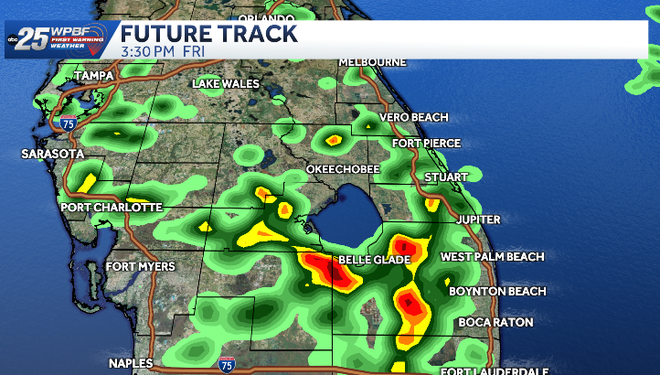
WPBF 25 First Warning meteorologists are tracking impact weather Friday and Saturday across South Florida. Heavy rain, lightning, and gusty winds are expected Friday afternoon. The hot and humid environment and an area of low-pressure overhead will trigger some stronger storms.Impact Weather Outlook”Today and tomorrow will feature showers and a few strong storms, some near the coast in the morning, but most will be inland during the afternoon and early evening. Rain chances are around 50% for both days. Most rainfall will decrease as we get into the evening hours.” – Glenn Glazer Friday: Hot and humid with highs in the low 90s and feels-like temps in the 100sScattered rain and storms with 50% coverage and a few strong cells Saturday: Hot and humid with highs in the low 90s and feels-like temps in the 100s Scattered rain and storms with 40% coverage Rain should be pretty spotty after sunset Next few days: Isolated to scattered storms over the coming days Hot and humid Tracking the TropicsStay with WPBF 25 on-air and online for updates.2026 Hurricane SeasonInteractive radarSevere Weather Alerts Download the WPBF 25 News app for the most up-to-date weather alerts.
WPBF 25 First Warning meteorologists are tracking impact weather Friday and Saturday across South Florida.
Heavy rain, lightning, and gusty winds are expected Friday afternoon.
The hot and humid environment and an area of low-pressure overhead will trigger some stronger storms.
Impact Weather Outlook
“Today and tomorrow will feature showers and a few strong storms, some near the coast in the morning, but most will be inland during the afternoon and early evening. Rain chances are around 50% for both days. Most rainfall will decrease as we get into the evening hours.” – Glenn Glazer
Friday:
Hot and humid with highs in the low 90s and feels-like temps in the 100sScattered rain and storms with 50% coverage and a few strong cells
Saturday:
Hot and humid with highs in the low 90s and feels-like temps in the 100s Scattered rain and storms with 40% coverage Rain should be pretty spotty after sunset
Next few days:
Isolated to scattered storms over the coming days Hot and humid
Tracking the Tropics
Stay with WPBF 25 on-air and online for updates.
Download the WPBF 25 News app for the most up-to-date weather alerts.