
Heat cranks up across Central Florida; rain chances go down on Wednesday
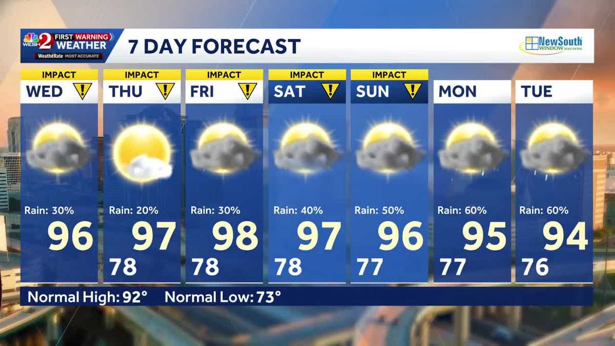
ATHLETE, THE SHOOTING THING? YEAH. ANYWAY, ALL RIGHT. WE’VE GOT BIG HEAT ACROSS THE USA 108 IN THE VILLAGE. YEAH. LET’S TALK ABOUT IT. HEAT WAVE BEGINS TODAY. AND AS IT DOES, OUR RAIN CHANCES ARE DROPPING. SO TODAY, 96 BY FRIDAY, ACTUAL TEMPERATURE IS 98 DEGREES. AND THIS TYPE OF WEATHER PATTERN MEANS WE HAVE TO PULL OUT WAYS TO REALLY MAKE THIS. AND THE WEATHER SERVICE A COUPLE OF YEARS AGO CAME OUT WITH WHAT THEY CALL THE HEAT RISK SCALE. OKAY. IT’S I WANT TO TAKE YOU THROUGH THIS. ALL RIGHT. BECAUSE PARTICULARLY LOOK AT THE MAJOR AND EXTREME, THE MAJOR IN RED MEANS IT IMPACTS THOSE WITHOUT COOLING. THE EXTREME IS A RARE EVENT WHICH IMPACTS THOSE WITHOUT COOLING AND HYDRATION. FOR TODAY, WE’RE IN A MAJOR HEAT RISK. OKAY, THEN, LOOKING AHEAD TO TOMORROW, WE START TO SEE THOSE PURPLES. LOOKING AHEAD TO FRIDAY, THE PURPLES. SAME THING FOR SATURDAY. WE’RE GETTING INTO A PARTICULARLY RARE HEAT EVENT, SO WE REALLY GENUINELY I KNOW IT’S HOT EVERY DAY IN FLORIDA. THIS IS A RARE EVENT. TEN DIFFERENT RECORDS LIKELY TO FALL ACROSS THE PENINSULA, OR AT LEAST TEN DIFFERENT CITIES WITH MULTIPLE RECORDS. AND ONE OF THE BIG REASONS IS WE’VE GOT THIS SAHARAN DUST COMING ALL THE WAY OVER FROM AFRICA, DROPS OUR RAIN CHANCES, DRIES THE ATMOSPHERE, AND EVEN IMPACTS THE AIR QUALITY. AT LEAST IT MAKES FOR VIBRANT SUNRISES AND SUNSETS. SO THAT’S DEFINITELY SOMETHING TO WATCH FOR. SO FOR TODAY, SHOWERS, THUNDERSHOWERS, THAT RISK IS GOING TO BE LOWER. THE HEAT INDEX IS GOING TO BE VERY HIGH. AND IF YOU’RE HEADING TO THE BEACHES, LOWER RISK OF RIP CURRENTS. NOT BAD AT ALL. THAT’S WHY WE HAVE IMPACT WEATHER, NOT BECAUSE OF THE STORMS BUT BECAUSE OF THE HEAT 90 BY NOON, 95 DEGREES, OUR 3 P.M. TEMPERATURE. ALL RIGHT, OUTSIDE WE GO. IT’S BEAUTIFUL, DARK. AND EARLY ON THIS WEDNESDAY MORNING, TEMPERATURES OUT THE DOOR 70 AND 80. THERE IS SOME RAIN IN THERE 2:00, 3:00, 4:00, KIND OF WORKING FROM WEST TO EAST. NOT A SIGNIFICANT THREAT OF RAIN. THE BIGGER STORY TODAY AND OVER THE NEXT FEW DAYS THAT IMPACT WEATHER BECAUSE OF THE BUILDING HEAT. THE GOOD NEWS THOUGH, LOO
Heat cranks up across Central Florida; rain chances go down on Wednesday

Updated: 6:11 AM EDT Jul 8, 2026
Hot and much drier across Central Florida on Wednesday. Temperatures will reach the mid 90s, but feels-like temps could reach 108 degrees. Several counties are under heat advisories – and more could be added. The heat will stick around through Sunday, so the First Warning Weather Team is calling for Impact Weather through Sunday. First Warning Weather Stay with WESH 2 online and on-air for the most accurate Central Florida weather forecast.RadarSevere Weather AlertsDownload the WESH 2 News app to get the most up-to-date weather alerts. The First Warning Weather team includes First Warning Chief Meteorologist Tony Mainolfi, Eric Burris, Marquise Meda, Cam Tran and Victoria Wisniewski.What is Impact Weather?Impact Weather suggests weather conditions could be disruptive or a nuisance for travel and day-to-day activities.
Hot and much drier across Central Florida on Wednesday.
Temperatures will reach the mid 90s, but feels-like temps could reach 108 degrees.
Several counties are under heat advisories – and more could be added.
This content is imported from Twitter.
You may be able to find the same content in another format, or you may be able to find more information, at their web site.
Heat Advisory in effect Wednesday for much of northeast Florida and southeast Georgia. Heat index values could hit 110 degrees during the afternoon hours. That mid-day through early evening window Wednesday is the one to watch. pic.twitter.com/O1M4jvrTPe
— Eric Burris (@EricBurrisWX) July 8, 2026
The heat will stick around through Sunday, so the First Warning Weather Team is calling for Impact Weather through Sunday.
This content is imported from Twitter.
You may be able to find the same content in another format, or you may be able to find more information, at their web site.
First Warning Weather
Stay with WESH 2 online and on-air for the most accurate Central Florida weather forecast.
Download the WESH 2 News app to get the most up-to-date weather alerts.
The First Warning Weather team includes First Warning Chief Meteorologist Tony Mainolfi, Eric Burris, Marquise Meda, Cam Tran and Victoria Wisniewski.
What is Impact Weather?
Impact Weather suggests weather conditions could be disruptive or a nuisance for travel and day-to-day activities.