
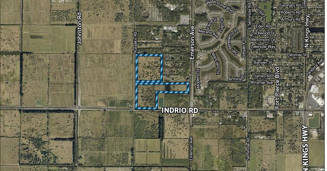
FORT PIERCE – The St. Lucie County Planning & Zoning Commission gave its initial nod June 18 to a future town center along the rapidly developing Indrio Road Corridor as part of the novel Towns, Villages & Countryside Land Use Overlay area.
Planner Don Arellano introduced the agenda item that evening.
“The applicant is proposing a rezoning to planned retail workplace and approval of a preliminary site plan with a request for a 1,500-foot extension of the Urban Services Boundary,” he said. “The 85.29-acre site is located between Emerson and Russakis Road on the north side of Indrio approximately 1.7 miles east of Interstate 95. The existing land use is towns, villages & countryside. The properties to the north, west and south have a TVC designation, and to the east and the northeast of Emerson Avenue properties have a Residential Urban and Conservation Public Designation.”
Arellano then detailed the reasoning behind the rezoning request from the land’s current agricultural zoning. When the county implemented the 28-square-mile TV&C Overlay area in 2006, it provided the legal pathways to rezone the land into various zoning districts in order to create clustered housing and commercial areas to prevent future urban sprawl. The area remained dormant for much of the ensuing two decades, however, due to the subsequent recession and lack of developer interest.
“The purpose of the Planned Retail/Workplace District is to accommodate landowners who choose to place retail or workplace land uses outside a town or village in a manner consistent with the goals, objectives and policies of the TVC element,” he continued. “The transferable development map establishes permissible densities based on the property’s previous future land use designation prior to the TVC adoption. For the subject property, the previous Agricultural 1 limits the residential density to one unit per acre. The PRW Zoning provides a mechanism to utilize the density assigned by the map or up to five mixed-use dwelling units, whichever is higher.”
Nearly 9000 of the approximately 14,000 TV&C acres lie outside of the county’s Urban Service Boundary, the motivation behind the applicant’s request for a minor adjustment of the same.
“The existing Urban Service Boundary currently terminates adjacent to the approved Publix and the Indrio Commons Development to the east,” Arellano explained. “The proposed USB adjustment simply provides the infrastructure and services needed to support the type of development the county anticipated for this location. The 1,500 foot adjustment westward to encompass the Indrio Town Center property creates a more cohesive planning framework for the corridor. This adjustment is not intended to promote scattered or leap-frog development; instead, it allows the site to connect to an area where commercial activity, infrastructure investment and utility planning are already underway.”
The county planner concluded with a description of the projected traffic impacts, while emphasizing the estimations would need to be reevaluated in the future.
“The analysis provided by the applicant states that the development will generate 10,980 daily trips with a peak a.m. hour of 465 and peak p.m. hour of 1,102 trips,” he said. “The proposed development will generate 14,203 daily driveway trips peaking at 631 in the a.m. and 1,405 in the p.m. The site is projected to receive 66 percent of trips coming west from Indrio Road and 20 percent of the trips coming east from Indrio Road. 13 percent of the projected trips would come from the south from Emerson Avenue and the remaining 1 percent would be coming north from Emerson Road. An adjusted traffic impact analysis would be required prior to final site plan.”
The applicant’s contracted Landscape Architect Leah Heinzelmann then provided more details.
“At its core, the request is about implementing the county’s adopted vision for the Towns, Villages & Countryside area,” she said. “One of the primary reasons this site is appropriate for a town center is its location along Indrio Road, one of the area’s primary east-west corridors with direct access to Emerson Avenue, Russakis Road, Kings Highway and I-95. These corridors connect the site to existing residential communities, employment centers and commercial destinations throughout the county.”
Heinzelmann pointed out that the preliminary site plan focused on Parcel 7 and included two options for its development.
“Parcel 7 contains approximately 16 acres and is limited to a maximum of 16 townhome units,” she explained. “Option A illustrates how Parcel 7 can be developed entirely as a commercial and workplace oriented component without residential. This concept reinforces one of the key PRW District objectives to create destinations where people can work, access services and conduct business in a walkable environment. Parcel 7 is limited to 105,000 square feet of commercial, office or workplace development. Option B illustrates the residential alternative for Parcel 7 and represents the only stand-alone residential housing type permitted within the PRW Zoning District.”
The applicant’s contracted Traffic Engineer Sean McKenzie also provided input.
“There’s not an extensive grid of roads out there today,” he admitted. “However, the county will create a road-grid network in this area covering all the way from Angle Road north to Indian River County. There’ll be a variety of different routes and choices that drivers will have in the future.”
After Commissioner William O’Dell posed several traffic-related questions to McKenzie, Commissioner Ed Lounds questioned Heinzelmann about vacant land on a later site plan phase.
“Can you please explain to me what your plans are for Phase 4 [and] why are there two large areas separated out?” he asked.
“At this point, we don’t know the market or what the county’s needs are going to be at that time,” she answered. “We didn’t want to propose something that might not actually come to fruition. That will have to come back before the Board at the time of Phase 4. It could not be residential; it would only be potentially for commercial.”
While Lakewood Park resident Justin Harrison advised the Board that more event parking might be needed in the future, one of his neighbors, Leah Norton, worried more about traffic.
“It’s a big concern with all of the development that’s even going on 43rd in Indian River County,” she said. “All that overflows onto Emerson and Indrio, and those are massive amounts of houses going in there. With these kinds of development and the road structures we have, we can’t handle the traffic.”
After further back-and-forth between Board members and the applicant’s representatives, most P&Z commissioner sided with Vice-Chairman Board Member Lawrence “Beau” Slay’s assessment.
“I like the project,” he said. “I also love anytime we create green space. I think we’re seeing a lot more of developed green space, meaning uses that people outside of that vicinity can come in and use. I’m not a fan of high-density – I know Indrio Groves is what it is – but I understand how it coincides with what you guys are trying to do here.”
The P&Z Commission then voted unanimously to recommend approval to the County Commission.