
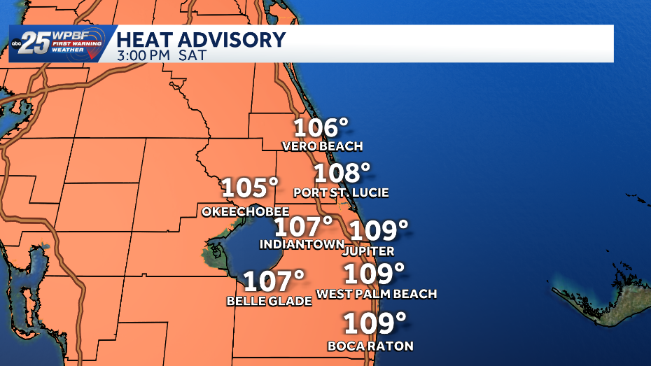
South Florida under heat advisory as temperatures feel like 110 degrees
Heat index could reach 110
INSIDE OF A HOT VEHICLE. JUST HORRIBLE TO SEE THAT DOG. YOU KNOW, IT’S IT’S HARD TO HEAR THAT THEY COULDN’T EVEN STAND. THAT’S HOW HOT THEY WERE. IT’S SO SAD. AND THINK ABOUT IT. WOULD YOU WANT TO BE SITTING IN THAT SITUATION? SO PEOPLE REALLY NEED TO THINK ABOUT THIS ESPECIALLY IT’S SO HOT WHEN YOU STEP OUTSIDE. I MEAN, THE FEELS LIKE TEMPERATURE OVER THE LAST FEW DAYS HAVE BEEN IN THE HUNDREDS. YES. AND THAT IS GOING TO CONTINUE OVER THE COMING DAYS. DANGEROUS HEAT FOR THIS AFTERNOON AND INTO TOMORROW AFTERNOON. TEMPERATURES ALREADY GOING TO BE SITTING ABOVE AVERAGE. AND THEN YOU FACTOR IN THE HUMIDITY. THAT’S GOING TO LEAD TO FEELS LIKE TEMPERATURES ANYWHERE BETWEEN 105 AND 110 DEGREES FOR THIS AFTERNOON AND INTO TOMORROW AFTERNOON. SO PLEASE NEVER LEAVE YOUR KIDS OR YOUR PETS INSIDE OF A CLOSED CAR AND MAKE SURE YOU’RE DRINKING PLENTY OF WATER. MAKE SURE YOUR PETS HAVE PLENTY OF COOL WATER AS WELL, AND A COOL PLACE TO BEAT THE HEAT. WE DO HAVE A HEAT ADVISORY IN PLACE STARTING AT 11:00 THIS MORNING, AND IT WILL RUN UNTIL 7:00 TONIGHT, SO JUST AVOID STRENUOUS ACTIVITY THROUGH THE TWO, THREE, 4:00 HOUR, ESPECIALLY RIGHT NOW. TEMPERATURES A LOT MORE MILD COMPARED TO WHAT WE’RE IN FOR. 74 AT VERO BEACH, 74 RIGHT NOW IN STUART. AND WE’RE CURRENTLY AT 74 IN JUPITER FARMS. AS WE TAKE A LOOK AT THE SAHARAN DUST RIGHT NOW, NOT SEEING TOO MUCH OF IT. AND THAT’S WHY WE HAVE BEEN ABLE TO SEE SOME MOISTURE SNEAK IN, ALLOWING FOR THOSE SHOWERS THAT WE DEALT WITH THROUGH THOSE OVERNIGHT HOURS. AND WE’RE STILL SEEING A COUPLE OF SPOTTY SHOWERS OUT THERE, BUT RAIN CHANCES WILL REMAIN FAIRLY LOW FOR THE REST OF THE DAY. JUST A POSSIBILITY OF A COUPLE OF SHOWERS AND A STRAY STORM OR TWO DEVELOPING LATER ON THIS AFTERNOON. WITH THE HEAT OF THE DAY. BUT IF YOU WANT TO GET OUTSIDE TODAY, I WOULD DO IT IN THE MORNING. BECAUSE AGAIN, AS WE PROGRESS INTO THOSE AFTERNOON HOURS, IT IS GOING TO BE WAY TOO STEAMY OUT THERE. SO IMPACT WEATHER FOR TODAY BECAUSE OF THAT HEAT ADVISORY, ABOUT 30% COVERAGE OF SHOWERS AND THE POSSIBILITY OF A STRAY STORM OR TWO. HERE’S A LOOK AT YOUR DAY ON FUTURECAST. YOU CAN SEE RAINFALL GOING TO BE A LITTLE BIT MORE THAN WHAT WE HAVE BEEN EXPERIENCING OVER THE LAST COUPLE OF DAYS, BUT STILL FAIRLY LIMITED ACROSS OUR AREA AS THAT SAHARAN DUST IS GOING TO BEGIN TO SURGE RIGHT BACK IN AS WE HEAD INTO TONIGHT AND INTO OUR SUNDAY. SO NOTICE A SUNDAY GOING TO BE ANOTHER HOT ONE. TEMPERATURES NEAR 95 DEGREES. AND TAKE A LOOK AT THAT RECORD. THIS IS FOR THE WEST PALM AREA 95 IS A FORECASTED HIGH. AND THAT RECORD IS AT 97 DEGREES. SO IT IS VERY LIKELY THAT WE WILL HAVE ANOTHER ROUND OF HEAT ADVISORIES IN PLACE FOR YOUR SUNDAY. AND JUST TAKE A LOOK AT YOUR FIRST WARNING WEATHER SEVEN DAY FORECAST. HOT TEMPERATURES GOING TO BE STICKING AROUND WITH HIGHS MAINLY TOPPING OUT IN THE MID 90S FOR MOST OF US OVER THE NEXT SEVEN DAYS. AS THAT SAHARAN DUST REALLY STIC
South Florida under heat advisory as temperatures feel like 110 degrees
Heat index could reach 110

Updated: 10:48 AM EDT Jul 11, 2026
Dangerous heat continues across South Florida as WPBF 25 First Warning meteorologists monitor heat index values as high as 110 degrees.A heat advisory is in effect for Palm Beach County from 11 a.m. until 7 p.m. Feels like temperatures could reach 110 degrees. What to expectSaturday: Hot and humid with highs in the mid-to-upper 90s. Only a 30% chance of rainSaharan dust remains in the areaSunday: Continued heat and humidity, with highs in the mid-to-upper 90s and feels-like temperatures above 100 degrees 20% chance for a few showers Saharan dust expected to increaseNext few days: Rain chances remain low due to Saharan dust Hot with highs in the mid-90s for most Near-record heat is possibleTracking the TropicsStay with WPBF 25 on air and online for updates.Interactive radarSevere Weather Alerts Download the WPBF 25 News app for the most up-to-date weather alerts.
Dangerous heat continues across South Florida as WPBF 25 First Warning meteorologists monitor heat index values as high as 110 degrees.
[image id=’8c81b55b-3f31-49d5-95fd-55e2706f1b96′ mediaId=’7ce04065-7755-46de-b146-68d4af98913e’ align=’center’ size=”medium” share=”true” caption=’Heat index could reach 110 with showers across South Florida’ expand=” crop=’original’][/image]
A heat advisory is in effect for Palm Beach County from 11 a.m. until 7 p.m.
Feels like temperatures could reach 110 degrees.
What to expect
Saturday:
Hot and humid with highs in the mid-to-upper 90s.
Only a 30% chance of rainSaharan dust remains in the area
Sunday:
Continued heat and humidity, with highs in the mid-to-upper 90s and feels-like temperatures above 100 degrees 20% chance for a few showers Saharan dust expected to increase
Next few days:
Rain chances remain low due to Saharan dust Hot with highs in the mid-90s for most Near-record heat is possibleTracking the Tropics
Stay with WPBF 25 on air and online for updates.
[related id=’00b1683e-f8e8-4f22-adfb-56fe5b18afad’ align=’center’ source=””][/related]
Download the WPBF 25 News app for the most up-to-date weather alerts.