
The Brief
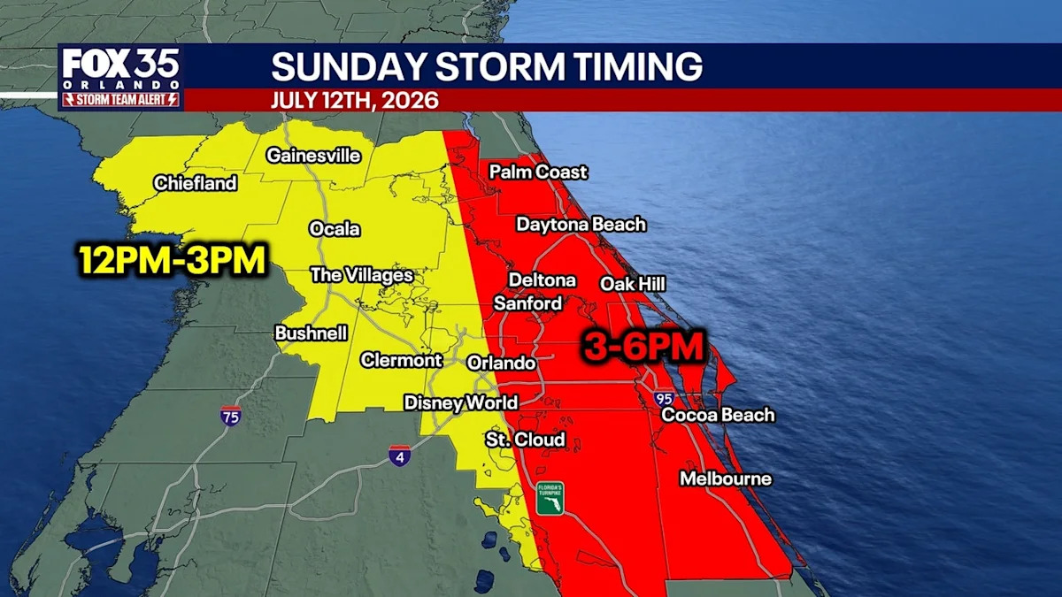
A FOX 35 Storm Team Alert remains in place for Sunday as a shifting weather pattern brings a 60% chance of severe afternoon thunderstorms to metro Orlando between 3 p.m. and 6 p.m.
While a thick, incoming layer of Saharan dust will create vibrant sunsets, it will also lower regional air quality for sensitive groups before drying out the atmosphere later this week.
By Tuesday, the dust layer will cap rain chances at just 20%, causing temperatures to skyrocket back into the upper 90s with feels-like heat index values tracking well over 100 degrees.
Though a relentless heat dome has locked in record-breaking temperatures over the past few days, a wave of afternoon storms is still expected to move into Central Florida by Sunday evening.
With a dense plume of Saharan dust overhead and a FOX 35 Storm Team Alert in place, residents can expect a hot, humid, and wet end to the weekend.
Storm chances for July 12, 2026
The drier air in play, along with the instability in the atmosphere, brings the threat of a few strong to severe storms for Sunday.
Rain chances spike to around 60% through the early evening, with numerous storms expected. The storms ignite with the help of the sea breeze and a bit of upstairs energy.
We’ll see these storms start around midday across the Gulf Coast, becoming more widespread across Orlando between 3 and 6 p.m. With the dry air aloft, gusty wind is the main concern as well as frequent lightning. Any strong storms will also produce torrential rain.
Forecast: See the storm move from the afternoon to eveningSaharan dust travels through Central Florida
The wind across the Atlantic is ushering a thick plume of dust up toward the Peninsula and the concentration in the air looks even higher for the weekend.
Not only does this aid in tempering down our rain chances into midweek, it also aids in bringing us vibrant sunrises/sunsets. However, the reduced air quality can present issues for those dealing with respiratory illness. This dust looks to remain in Central Florida as we progress through this upcoming workweek and into next weekend.
 Heat index shows feels-like temperatures over 100
 Rain chances drop
The Saharan Dust in the air that moves our way through the next few days will continue to impact our threat of showers and storms.
Drier air overhead will aid in limiting rain chances to near 20% Tuesday into the latter half of next week. A few showers and storms are still on the docket though, and some could still become strong to severe if they do get going. Chances do start to go back up Friday into next weekend.
 Temps stay steamy
With the drier air and the dust, temperatures are expected to climb once again, with the potential for more Heat Advisories being issued.
The forecast highs could soar back above normal, topping out in the middle to upper 90s with feels like temps in the middle to upper 100s.
The Source
Information in this story was gathered by FOX 35’s T.J. Springer.