
Storms to finish off the weekend in Central Florida as temps remain in the upper 90s
All right, we have been dealing with some very hot and muggy conditions out there, but the rain has actually cooled things off *** little bit. Yeah, we’re still going to remain muggy tonight, so we can’t get rid of it all here in Central Florida. Marquis, why can’t you just tell me some good news? Uh, well, I got to start with the bad and then work my way to the good, you know, give the people what they want at the end. But yes, we are trending *** little bit cooler now. In fact, here’s *** look at the difference that 24 hours could make. We started the showers *** bit earlier this afternoon in comparison to Saturday. And the earlier we start the rain, well, the quicker we could push it on shore. So with the passing of the rain showers, temperatures have dropped 16 degrees from where we were at this point in time yesterday in Orlando. That’s *** 15 degree difference in Bit low, 14 degree difference in Titusville. So it’s nice to step outside and not be still hanging around the 90s, and that’s courtesy of the ongoing rain that we are seeing and what we’ve seen already so far today with that westerly push. Right now in Orlando, just light showers do linger. Temperatures have dropped to 77 degrees. You still have that breeze coming in from the southwest though at 5 MPH. But everywhere here in central Florida, we’re hosting temperatures currently that are back in the 70s. No 80s, no 90s on the board. Still dealing with some lightning strikes across Melbourne and Cocoa Beach, but ultimately across our north and westernmost communities, barely any rain to be seen there, wiping away the showers here in Orange County. You see those in Bitlow across Toll 528. Further off towards the east, what It was moderate rain. It has now become light in Cape Canaveral. Also Cocoa Beach, and across the South, we see some stronger showers across, uh, Keenansville into Yeehan Junction. These are pushing east into Felsmere as we speak here. What’s been left behind though, significant rain across parts of Melbourne. Also Floriana Beach, 2.5, uh, 2.6 inches there, 2.5 across Cocoa, over 3 inches as you head further north into the Titusville area. Back out towards the west we go into Oak Ridge, also Lake Hart, 1 to 2 inches of rain as well. What you guys have seen, we started off the day with heavier showers in Marion County, Ocala, where our David Jones was just *** second ago. 2.6 inches of rain out that direction. Ormond Beach, 2.3. Some rain widespread across Central Florida today, but as I mentioned, it was an earlier start. So give it *** few more hours. We’ll see the heavier showers come to an end. Still just light rain heading into the 9 o’clock hour across the coastline. And then after that, it’s smooth sailing into the start of your work week in which we’ll see partly cloudy skies. To kick off your Monday morning with temperatures back in the mid 70s, so we’ll see these numbers fluctuate just *** bit after we get rid of the showers in the mid 70s at 7 and 9 o’clock, upper 70s at 11, but slowly over time we’ll work our way down to 77 degrees in Orlando. Temperatures spread across central Florida to start off the morning will be anywhere between 75 and 78, so it’s *** tight-knit grouping of numbers to start off your Monday. Humid though, as the storms push offshore and then score. Temperatures with triple digit fields like conditions. We’ll be back as we kick off the work week tomorrow. Rain coverage right around 30 to 40% inland. We’ll see more chances for showers across the start of your work week as opposed to the middle portion. And that’s because another plume of Saharan dust does arrive, and we’ll be watching this system of high pressure off in the Atlantic direct your winds from the south and the east. So an increased rip current threat does remain in the picture, but we’ll start to see those showers coming from the west early to start off your Monday at 10:00. And then into the metro at 1 and 2 pushing towards the east as we move across the rest of your Monday as well. Here’s that plume of Saharan dust drying us out towards the middle of the work week. Still though, the heat risk tomorrow going to be major in some areas as temperatures return to the mid 90s on Monday. 94 on Monday. Notice temperatures are climbing through Thursday in which that dry weather has us in the upper 90s. 97 for your high on Thursday with mostly sunny skies coming your way.
Storms to finish off the weekend in Central Florida as temps remain in the upper 90s

Updated: 6:31 PM EDT Jul 12, 2026
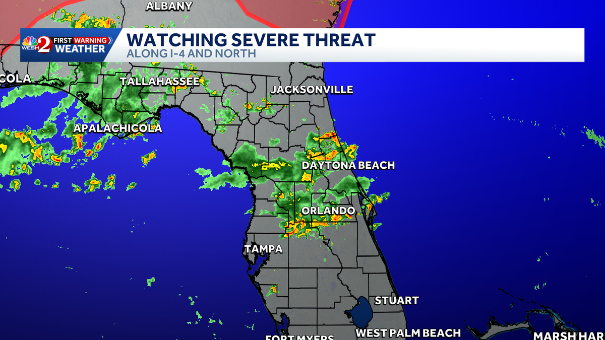
Ending off the weekend with plenty of heat as showers and storms move in Sunday afternoon.Many parts of Central Florida will feel like the lower 100s this afternoon, with Flagler County under a heat advisory as they reach heat indices up to 110 degrees.A strong westerly sea breeze will bring storms moving in from west to east, bringing heavy rain and gusty winds to 60% of the Orlando area. Some cells will have the risk of dropping 2-3″ per hour rain rates, posing an isolated risk for flooding. Storms will move out between 8 and 9 p.m.Active alertsThere are no active alerts at this time.First Warning Weather Stay with WESH 2 online and on-air for the most accurate Central Florida weather forecast.RadarSevere Weather AlertsDownload the WESH 2 News app to get the most up-to-date weather alerts. The First Warning Weather team includes First Warning Chief Meteorologist Tony Mainolfi, Eric Burris, Marquise Meda, Cam Tran and Victoria Wisniewski.What is Impact Weather?Impact Weather suggests weather conditions could be disruptive or a nuisance for travel and day-to-day activities.What is a Severe Weather Warning Day?A Severe Weather Warning Day suggests weather conditions that could potentially harm life or property. ————————————————DOWNLOAD the free WESH 2 News app for your latest news and alerts on breaking news, weather, sports, entertainment and more on your phone or tablet. And check out the Very Local app to stream news, entertainment and original programming on your TV.
Ending off the weekend with plenty of heat as showers and storms move in Sunday afternoon.
Many parts of Central Florida will feel like the lower 100s this afternoon, with Flagler County under a heat advisory as they reach heat indices up to 110 degrees.
A strong westerly sea breeze will bring storms moving in from west to east, bringing heavy rain and gusty winds to 60% of the Orlando area.
Some cells will have the risk of dropping 2-3″ per hour rain rates, posing an isolated risk for flooding.
Storms will move out between 8 and 9 p.m.
Active alerts
There are no active alerts at this time.
First Warning Weather
Stay with WESH 2 online and on-air for the most accurate Central Florida weather forecast.
Download the WESH 2 News app to get the most up-to-date weather alerts.
The First Warning Weather team includes First Warning Chief Meteorologist Tony Mainolfi, Eric Burris, Marquise Meda, Cam Tran and Victoria Wisniewski.
What is Impact Weather?
Impact Weather suggests weather conditions could be disruptive or a nuisance for travel and day-to-day activities.
What is a Severe Weather Warning Day?
A Severe Weather Warning Day suggests weather conditions that could potentially harm life or property.
————————————————
DOWNLOAD the free WESH 2 News app for your latest news and alerts on breaking news, weather, sports, entertainment and more on your phone or tablet. And check out the Very Local app to stream news, entertainment and original programming on your TV.