
Gradual warming trend continues today for Central Florida
POTENTIAL PLANS. ALL RIGHT. YOUR TIME RIGHT NOW IS 517. AND FOLKS, IT FEELS GREAT OUT THERE THIS MORNING. RIGHT NOW THOSE TEMPERATURES AGAIN THEY WILL WARM UP. BUT WE DO HAVE ANOTHER COLD FRONT COMING OUR WAY LATER ON. YEAH, WE’RE TRYING TO PUSH THAT AS FAR DOWN THE LINE AS WE CAN. RIGHT. BUT SUNSHINE THAT’S GOING TO BE THE STAPLE IN THE FORECAST THIS AFTERNOON. RIGHT. AND WE’LL SEE THAT ACROSS THE REST OF THE WORKWEEK UP UNTIL FRIDAY. SMALL CHANCE FOR SOME SHOWERS STILL THOUGH AS WE MOVE ACROSS THE WORKWEEK, EVEN ALONG THE COAST, TEMPERATURES WILL BE RIGHT AROUND THEIR SEASONAL AVERAGE, IF NOT A PINCH WARMER. AS WE’RE BACK IN THE LOW 80S TODAY, UPPER 70S THURSDAY, AND THEN ON FRIDAY WE SEE THAT CHANCE FOR RAIN HANGING AROUND 30%. WITH TEMPERATURES STILL IN THE LOW 80S. IT WON’T BE UNTIL THE BACK END OF YOUR SEVEN DAY MOST ACCURATE FORECAST THAT WE SEE THOSE TEMPERATURES CRAWL INTO THE 60S ON MONDAY AND TUESDAY, SO BE PREPARED TO BUNDLE UP AS WE KICK OFF YOUR NEXT WORK WEEK. BUT FOR THE MOMENT, WE ARE TRENDING WARM ACROSS CENTRAL FLORIDA WITH MOSTLY CLEAR SKIES. SO FAR THIS MORNING LOOKS BEAUTIFUL IN SANFORD TOO. LOOKS LIKE THE MOON IS STILL LIGHTING UP THE WATER HERE ACROSS LAKE MONROE. TEMPERATURES AT 64 DEGREES WITH A BREEZE FROM THE NORTH AND THE WEST AT SEVEN MILES PER HOUR. GOT A COUPLE CLOUDS IN THE FORECAST RIGHT NOW, BUT ULTIMATELY YOU ARE COOLER AS YOU HEAD FURTHER WEST. MID 50S FOR OCALA, WILDWOOD, UPPER 50S IN THE VILLAGES AND PALM COAST 60S EVERYWHERE ELSE HERE AT 518. AND IT’S THE 50S AND 60S THAT WE’RE REPORTING TODAY THAT FEEL A LOT WARMER IN COMPARISON TO YESTERDAY. IN FACT, SOME PLACES, EVEN PLUS TEN DEGREES, JUST LIKE OCALA, WITH THOSE CALM WINDS PRIMARILY, WE’LL SEE THAT EAST COAST SEA BREEZE LATER IN THE AFTERNOON BEGIN TO PICK UP WIND SPEEDS BETWEEN 15 OR 10 TO 15MPH TODAY, BUT WE’RE STILL WATCHING THE CHANCE FOR SOME FOG AS THE WINDS REMAIN CALM. SO FAR THIS MORNING, WE’RE UNDER HIGH PRESSURE. WE HAVE A LITTLE BIT OF MOISTURE IN THE ATMOSPHERE, AND WITH THOSE CALM WINDS, WE HAVE THE RECIPE FOR SOME FOG TO SETTLE INTO YOUR MORNING FORECAST BEFORE 8:00, BUT THAT FOG WILL LIFT ONCE TEMPERATURES BEGIN TO RISE. WE’LL RISE ALL THE WAY INTO THE LOWER 80S INLAND TODAY, UPPER 70S ALONG THE COAST. WITH THAT PERSISTENT SUNSHINE IN THE FORECAST AND ALSO IN THE FORECAST. NO DEVELOPMENT EXPECTED ACROSS THE TROPICS FOR THE NEXT SEVEN DAYS. GREAT NEWS THERE AS WE CONTINUE ACROSS THE MONTH OF NOVEMBER, THERE ARE CHANCES FOR US TO SEE AREAS OF LOW PRESSURE BEGIN TO SPIN UP. THE MOST HURRICANES WE’VE EVER SEEN. IN THE MONTH OF NOVEMBER 3RD SO FAR ZERO. AND WE’RE HOPING TO KEEP THAT GOOSE EGG IN THE FORECAST. AS FAR AS ANY TROPICAL STORMS ARE CONCERNED, HIGH PRESSURE WILL SIT TO OUR NORTH AND EAST THROUGHOUT THE REMAINDER OF THE DAY, AND AS WE CONTINUE ACROSS THE WORKWEEK, IT WILL SAG TOWARDS THE SOUTH. THAT WILL OPEN UP THE DOOR FOR A COUPLE COASTAL SHOWERS ON FRIDAY, BUT FOR TOMORROW, TEMPERATURES ARE JUST AS WARM AS THEY WILL BE TODAY. ANYWHERE BETWEEN THE LOW 70S AND THE LOW 80S. WITH SUNSHINE BACK IN THE PICTURE, WE’LL TRY TO STRETCH THAT SUNSHINE ACROSS YOUR SATURDAY FORECAST. BUT ON SUNDAY GET A LITTLE BIT OF CHANGE COMING OUR WAY. THIS IS OUR NEXT COLD FRONT. IT’S GOING TO TAKE US FROM SUNDAY INTO MONDAY WITH THE CHANCE FOR SHOWERS, BUT ONCE IT PASSES BY US ON MONDAY, WE’LL SEE THOSE TEMPERATURES DROP SIGNIFICANTLY. IN FACT, THESE ARE YOUR WAKE-UP. TEMPERATURES ON TUESDAY GOT A MIX OF 30S AND 40S, SO UNFORTUNATELY WE’LL BE DROPPING QUITE QUICKLY HERE IN CENTRAL FLORIDA. SO SOAK UP THE SUNSHINE WHILE YOU STILL CAN. YOUR SEVEN DAY MOST ACCURATE FORECAST DOES SHOW US IN THE 80S ALL WEEK LONG, AND IT WON’T BE UNTIL MONDAY UNTIL WE DROP INTO THE 70S COMING UP. AND THEN EVENTUALLY THE 60S ON TUESDAY FOR YOUR AFTERNOON HIGHS.
A high risk of life-threatening rip currents will persist along Atlantic beaches today, with the chance of these conditions continuing through the end of the week.Although sunny weather is expected for most of the week, it is crucial to check flag conditions before entering the water. High pressure continues to dominate the forecast, resulting in rain-free conditions as a drier airmass remains overhead.A gradual warming trend will continue today, with highs reaching the low 80s. Overnight lows will range from the upper 50s to the low 60s along the southeast coast. Dry conditions are expected to persist through much of the week, with low rain chances returning over the weekend ahead of another cold front.A stronger front is forecast to move through early next week, bringing a noticeable cool down. Residents are encouraged to enjoy the dry, warmer weather and sunshine before the next front arrives. East winds continue to produce dangerous rip currents and high surf of 3 to 4 feet.First Warning Weather Stay with WESH 2 online and on-air for the most accurate Central Florida weather forecast.RadarSevere Weather AlertsDownload the WESH 2 News app to get the most up-to-date weather alerts. The First Warning Weather team includes First Warning Chief Meteorologist Tony Mainolfi, Eric Burris, Marquise Meda and Cam Tran.
ORLANDO, Fla. —
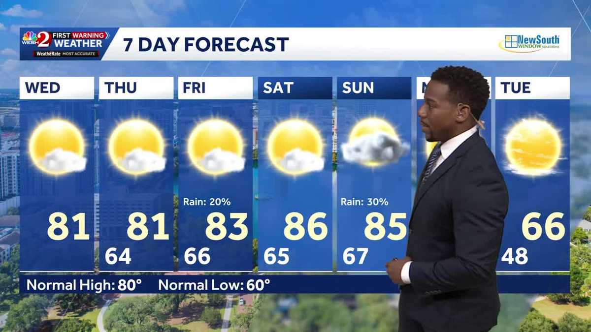
A high risk of life-threatening rip currents will persist along Atlantic beaches today, with the chance of these conditions continuing through the end of the week.
Although sunny weather is expected for most of the week, it is crucial to check flag conditions before entering the water. High pressure continues to dominate the forecast, resulting in rain-free conditions as a drier airmass remains overhead.
A gradual warming trend will continue today, with highs reaching the low 80s. Overnight lows will range from the upper 50s to the low 60s along the southeast coast. Dry conditions are expected to persist through much of the week, with low rain chances returning over the weekend ahead of another cold front.
A stronger front is forecast to move through early next week, bringing a noticeable cool down. Residents are encouraged to enjoy the dry, warmer weather and sunshine before the next front arrives. East winds continue to produce dangerous rip currents and high surf of 3 to 4 feet.
First Warning Weather
Stay with WESH 2 online and on-air for the most accurate Central Florida weather forecast.
Download the WESH 2 News app to get the most up-to-date weather alerts.
The First Warning Weather team includes First Warning Chief Meteorologist Tony Mainolfi, Eric Burris, Marquise Meda and Cam Tran.