
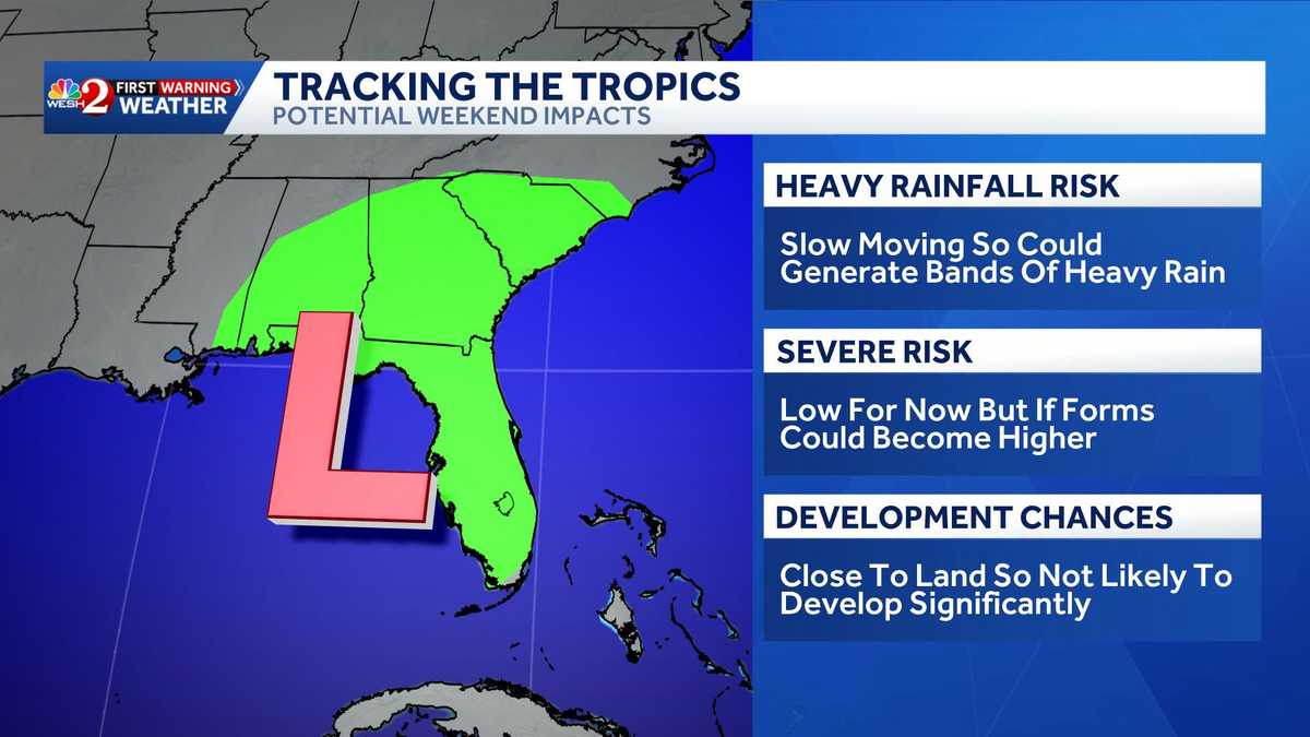
Area of interest in Gulf could bring heavy rain to Central Florida this weekend
There’s another, believe it or not, there’s another good thing, OK, OK. It may not seem it at the surface, but we dive *** little deeper. OK, right, so let’s just start off by talking about the tropics, and there’s nothing that is blowing up right now, but the hurricane center monitoring the chance of seeing an area of low pressure forming in the Gulf, crossing slowly over the peninsula and then looping away. You may have seen this. I’m posting this on my social channels just to make sure everybody knows. But while there is some slow development possible, heavy rains are in the forecast across Florida, and I want to illustrate the big kind of questions in the room. Development or not, our rain chances are rising. We are not going to be looking at *** hurricane forming this weekend. None of the models are showing that at all. OK, so that’s very, very important. So while we continue to watch kind of run to run consistency here, let’s talk about what’s good about this, which is the rain. Fall and how the East Coast doesn’t need rainfall. The West Coast, the Metro does need rainfall. The orange in Orlando, we’re still in *** severe drought, believe it or not. Our western areas and up into the Big Bend, we’re under an extreme drought condition and to really put pen to paper here, Orlando is *** foot behind where we should be this time of year. Now Leesburg, you’ve had *** bunch of rain, obviously many of our areas have, but there is still *** drought in. Place. So any rain that does fall actually is not *** terrible idea, and these orange shades, that’s 3 to 5 inches of rain over the next 7 days. So we’re forecasting *** pretty significant rain event, particularly for the I-75 corridor and then into our area in yellow. That’s widespread 2 to 3 inches. So in making plans now that we’re pushing to the back half of the work week, just know that the weekend forecast is looking wetter and wetter and then into next week. Continuing wetter outside this morning though, that’s not the case. It’s quite lovely here in Ocala, just definitely muggier. It’s mid to upper 70s out the door. Our first morning live radar actually tracking 17 lightning strikes. This little cell here working down toward Ridge Manor, Dade City, putting out *** few flashes of lightning and rumbles of thunder. More rain over here towards Cedar Key, and the forecast essentially this morning is relatively quiet. Then lunchtime into the afternoon we’ll bubble up those shower chances. 456 o’clock starting out west and then little by little popcorning up through the 345 o’clock time frame and then dinnertime, bedtime, it all works off toward the east, *** decent coverage of rain today. 7 day forecast coastal edition showing those rising rain chances into the weekend. Even our metro 60-70% coverage of rain. It’s going to be getting wetter and wetter this weekend. So get out when you can, but when you can’t have those cleaning plans perhaps ready to go, Megan. Yeah.
Area of interest in Gulf could bring heavy rain to Central Florida this weekend

Updated: 7:06 AM EDT Jul 16, 2026
A tropical system could develop near Florida this weekend. The National Hurricane Center is monitoring a disturbance located offshore of the Southeastern U.S.The disturbance is forecast to develop into an area of low pressure this weekend. Slow development is possible as it moves slowly northeastward near the coast of the United States by early next week, according to the NHC.Formation chances over the next 48 hours: 0%Formation chances over the next seven days: 20%The system is slow-moving, which means it could generate bands of heavy rain in Central Florida. Colorado State University lowered its predictions for the number of named storms expected this year to its lowest tally in a decade.Related: CSU lowers 2026 Atlantic hurricane season forecast citing El NiñoCSU cites a Super El Niño for this reduction and is now calling for a total of nine named storms to form between now and Nov. 30.Tracking the TropicsStay with WESH 2 online and on-air for the most accurate Central Florida weather forecast.RadarSevere Weather AlertsDownload the WESH 2 News app to get the most up-to-date weather alerts.The First Warning Weather team includes First Warning Chief Meteorologist Tony Mainolfi, Eric Burris, Marquise Meda, Cam Tran and Victoria Wisniewski.>> 2026 hurricane season | WESH long-range forecast>> Download Very Local | Stream Central Florida news and weather from WESH 2
A tropical system could develop near Florida this weekend.
The National Hurricane Center is monitoring a disturbance located offshore of the Southeastern U.S.
The disturbance is forecast to develop into an area of low pressure this weekend.
Slow development is possible as it moves slowly northeastward near the coast of the United States by early next week, according to the NHC.
Formation chances over the next 48 hours: 0%Formation chances over the next seven days: 20%
The system is slow-moving, which means it could generate bands of heavy rain in Central Florida.
Colorado State University lowered its predictions for the number of named storms expected this year to its lowest tally in a decade.
Related: CSU lowers 2026 Atlantic hurricane season forecast citing El Niño
CSU cites a Super El Niño for this reduction and is now calling for a total of nine named storms to form between now and Nov. 30.
This content is imported from Twitter.
You may be able to find the same content in another format, or you may be able to find more information, at their web site.
Tracking the Tropics
Stay with WESH 2 online and on-air for the most accurate Central Florida weather forecast.
Download the WESH 2 News app to get the most up-to-date weather alerts.
The First Warning Weather team includes First Warning Chief Meteorologist Tony Mainolfi, Eric Burris, Marquise Meda, Cam Tran and Victoria Wisniewski.
>> 2026 hurricane season | WESH long-range forecast
>> Download Very Local | Stream Central Florida news and weather from WESH 2