
A tropical system could develop near Florida this weekend. The National Hurricane Center is monitoring a disturbance located in the Gulf, just offshore of the Southeastern U.S.The area of low pressure is forecast to form over the northeastern Gulf this weekend. Some gradual development of this system is possible as it meanders northward, bringing heavy rain to Florida’s west coast during the next several days. Formation chances over the next 48 hours: 10%Formation chances over the next seven days: 30% Regardless of the chances of formation, Central Florida is expected to see heavy rain throughout the weekend. Colorado State University lowered its predictions for the number of named storms expected this year to its lowest tally in a decade.Related: CSU lowers 2026 Atlantic hurricane season forecast citing El NiñoCSU cites a Super El Niño for this reduction and is now calling for a total of nine named storms to form between now and Nov. 30. Tracking the TropicsStay with WESH 2 online and on-air for the most accurate Central Florida weather forecast.RadarSevere Weather AlertsDownload the WESH 2 News app to get the most up-to-date weather alerts.The First Warning Weather team includes First Warning Chief Meteorologist Tony Mainolfi, Eric Burris, Marquise Meda, Cam Tran and Victoria Wisniewski.>> 2026 hurricane season | WESH long-range forecast>> Download Very Local | Stream Central Florida news and weather from WESH 2RESOURCES | HURRICANE SUPPLIES | SURVIVAL GUIDE | HURRICANE SEASON SPECIAL | WESH LONG-RANGE FORECAST | WHAT TO KNOW ABOUT INSURANCE | GENERATOR SETUP | TESTING CHAINSAWS | POST-STORM RESOURCES | DOWNLOAD WESH 2 APP
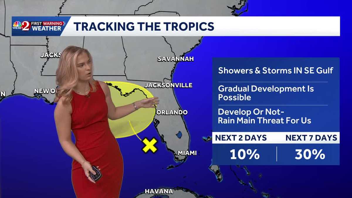
A tropical system could develop near Florida this weekend.
The National Hurricane Center is monitoring a disturbance located in the Gulf, just offshore of the Southeastern U.S.
The area of low pressure is forecast to form over the northeastern Gulf this weekend.
This content is imported from Twitter.
You may be able to find the same content in another format, or you may be able to find more information, at their web site.
Some gradual development of this system is possible as it meanders northward, bringing heavy rain to Florida’s west coast during the next several days.
Formation chances over the next 48 hours: 10%Formation chances over the next seven days: 30%
This content is imported from Twitter.
You may be able to find the same content in another format, or you may be able to find more information, at their web site.
Gulf system still tied to an upper-level low with no surface circulation. Odds unchanged at 10% through 48 hours, 30% through 7 days. Heavy rain remains the main threat for the FL west coast and Panhandle as it drifts north this weekend. pic.twitter.com/SnQL9jBhAS
— Eric Burris (@EricBurrisWX) July 18, 2026
Regardless of the chances of formation, Central Florida is expected to see heavy rain throughout the weekend.
Colorado State University lowered its predictions for the number of named storms expected this year to its lowest tally in a decade.
Related: CSU lowers 2026 Atlantic hurricane season forecast citing El Niño
CSU cites a Super El Niño for this reduction and is now calling for a total of nine named storms to form between now and Nov. 30.
Tracking the Tropics
Stay with WESH 2 online and on-air for the most accurate Central Florida weather forecast.
Download the WESH 2 News app to get the most up-to-date weather alerts.
The First Warning Weather team includes First Warning Chief Meteorologist Tony Mainolfi, Eric Burris, Marquise Meda, Cam Tran and Victoria Wisniewski.
>> 2026 hurricane season | WESH long-range forecast
>> Download Very Local | Stream Central Florida news and weather from WESH 2
RESOURCES | HURRICANE SUPPLIES | SURVIVAL GUIDE | HURRICANE SEASON SPECIAL | WESH LONG-RANGE FORECAST | WHAT TO KNOW ABOUT INSURANCE | GENERATOR SETUP | TESTING CHAINSAWS | POST-STORM RESOURCES | DOWNLOAD WESH 2 APP