
Isolated showers and storms in South Florida Saturday
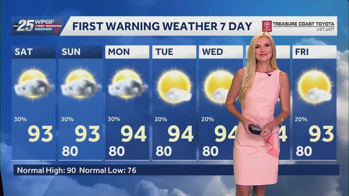
How much the wildfires can affect the United States, yeah, and those who are very sensitive, you know, it could have some major health impacts on them. So hopefully that clears up soon, but as we just heard, you know, today is going to be another big day and we’re seeing that even affecting our area with those fires in Broward and we saw Saint Lucie County with the storms possibly affecting that area. But what are we looking at in terms of the temperatures today? Today is going to be another hot one, not quite as hot as the last couple of days, so we don’t have that heated. Advisory in place for us here in South Florida. Temperatures will be sitting closer to the low to mid 90s. The last couple of days we were more so mid to upper 90s and feels like temperatures are going to be sitting in the 100s, but below that threshold for *** heat advisory to be issued. So whatever you get up to today, still make sure you’re drinking plenty of water, loose slight, comfortable clothes, don’t forget about your pets, and try to limit your time out in the sun or at least take frequent breaks away from the sun because it is still going to be hot out there. Temperatures currently sitting. Mid to upper 70s, *** few 80s as we look out towards southern portions of Palm Beach County. Heat index not playing *** role just yet. We have to wait for that sun to rise to really begin to see those effects. Now look at radar, dry across South Florida, but I do want to show you we do have some isolated showers just offshore streaming in from the south, and that’s all due to that area of low pressure, that upper level low sitting out in the Gulf. This is the area that does have *** very low end chance of becoming *** tropical system. That is going to continue to bring some isolated rainfall our way, not just for today but even into tomorrow because it is going to be drifting very slowly to the north towards the Florida panhandle, so not expecting any severe weather, just some spot showers and *** couple of storms for your Saturday and Sunday all prompted by this low. So as you can see here on your golf forecast, if you want to get outside, I recommend doing it early. We do have *** couple of spot showers in the forecast, however, that’s. Temperatures are going to be most comfortable because by the time we head into the afternoon it’s going to be hot and humid out there and you want to avoid too much time out in the sun. So about 30% coverage for today and you could see that here on Future track, just how spotty the rainfall is expected to be for us here on the east coast. Here’s *** look around 34 o’clock, you will notice isolated showers, *** couple of rumbles of thunder, and we will continue to see that isolated activity lingering. As we head into those early evening hours, but you will notice it is really going to be situated more so from Lake Okeechobee out to the west. That’s where you’re going to be seeing the most rainfall for today, as well as into tomorrow. So once again calling for isolated showers, *** couple of storms for your Sunday, about 30% coverage, you will notice *** couple of spot showers streaming in in the morning, and then into the afternoon we will be tracking some isolated activity as well. 30% coverage again on Monday, so really not big rain days in the forecast over the coming days, and then notice we’re really going to be drying out as we look ahead to the rest of the week, but temperatures over the next seven days will remain in the low to mid-nineties, so still well above our seasonal averages. All right, thank you, Nick.
WPBF 25 First Warning Meteorologist
For the first time in a while, we do not have a heat advisory in South Florida. However, it is still going to be a hot and humid one. High temperatures will climb into the low-to-mid 90s, with feels like temperatures in the 100s.Stay up to date: The latest headlines and weather from WPBF 25We will have the opportunity for isolated showers and a few storms Saturday. That is all going to be directed into South Florida due to an upper-level low that is producing rain and storms in the Gulf. The activity will be very isolated and spotty, as the bulk of Saturday’s activity will be directed toward the Gulf Coast. Get the latest news updates with the WPBF 25 News app. You can download it here.
For the first time in a while, we do not have a heat advisory in South Florida. However, it is still going to be a hot and humid one. High temperatures will climb into the low-to-mid 90s, with feels like temperatures in the 100s.
Stay up to date: The latest headlines and weather from WPBF 25
We will have the opportunity for isolated showers and a few storms Saturday. That is all going to be directed into South Florida due to an upper-level low that is producing rain and storms in the Gulf. The activity will be very isolated and spotty, as the bulk of Saturday’s activity will be directed toward the Gulf Coast.
Get the latest news updates with the WPBF 25 News app. You can download it here.