
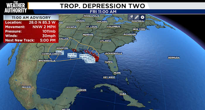
Per the National Hurricane Center, as of the latest advisory, Tropical Depression Two has formed in the eastern Gulf just off Florida’s west coast.
While this is not expected to become a major wind event, the biggest concern will be tropical rainfall.
The system is forecast to move slowly north to northwest over the next couple of days, spreading bands of heavy rain across portions of Florida and the northern Gulf Coast.
Periods of torrential rainfall could lead to localized flash flooding, especially in low lying and poor drainage areas.
Gusty winds are also possible in stronger rain bands, along with rough surf and an elevated risk of rip currents along Gulf Coast beaches.
Current forecasts indicate gradual strengthening is possible, and the depression could become Tropical Storm Bertha before making landfall.
Even if it remains a tropical depression, remember that water, not wind, is expected to be the primary threat with this system.
We’ll continue to monitor the latest track and intensity forecasts from the National Hurricane Center. If you live in flood prone areas, now is a good time to review your preparedness plans and stay alert for any watches or warnings that may be issued.
We’ll keep you updated every step of the way as Tropical Depression Two continues its track through the Gulf.
Copyright 2026 by WJXT News4JAX – All rights reserved.