
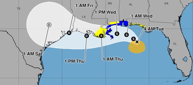
Tropical Storm Bertha, which formed Monday night near Florida’s Gulf coast, threatens a wide swath from the Panhandle to southern Texas with potential flooding and surge, posing particular risk to low-lying Louisiana, forecasters said Tuesday.
There is a risk of flash flooding through Friday on the Gulf Coast, including for western Florida north of Fort Myers, according to the National Hurricane center.
Bertha’s path will likely determine its intensity. If it takes a path closer to the coast, the less chance it has to gain strength over the warm waters of the Gulf. But drenching rainfall would pose a greater risk to coastal communities.
If Bertha intensifies over the Gulf, “strengthening to perhaps a high-end tropical storm or hurricane would be possible,” according to AccuWeather.
As of 5 a.m., Bertha was about 110 miles south-southwest of Panama City and 170 miles southeast of Mobile, Alabama, moving northwest at 5 mph, according to the National Hurricane Center.
Its maximum sustained winds were at 50 mph with higher gusts, and tropical-storm-force winds extend up to 80 miles from the center.
A tropical storm warning is in effect from the Florida/Alabama border west to the Jefferson/Plaquemines Parish border in Louisiana. A storm surge watch is in effect for the Alabama/Florida border to the mouth of the Mississippi River, the National Hurricane Center said.
A tropical storm watch is in effect for New Orleans, Lake Pontchartrain and from Florida’s Gulf/Bay county line west to the Alabama/Florida border.
Outer bands of the storm will bring heavy rain to parts of North Florida and ocean hazards to the Panhandle, the Florida Division of Emergency Management said in a post on X. The counties under a tropical storm watch are Bay, Escambia, Franklin, Gulf, Okaloosa, Santa Rosa and Walton.
The storm is expected to generate wind gusts up to 60 mph from the western Florida Panhandle to southeastern Texas, according to AccuWeather, in addition to the risk of flooding.
“It is expected to move “near or along the northern Gulf coast during the next several days,” the hurricane center said, “bringing at least 2 to 4 inches of rain with locally higher localized totals around 6 inches through Thursday along the Gulf Coast and adjacent inland locations from western Florida into Southern Louisiana Coast and southern portions of Alabama and Mississippi.”
Tropical Storm Bertha tracking map: Here’s the latest forecast path
Some strengthening is expected through Tuesday, though experts say the combination of dry air and hostile upper level winds over the Gulf may keep the system from strengthening markedly.
The majority of the rainfall and wind expected with the storm will likely be to the south of its center, forecasters said.
South Florida will not see any direct impacts from the storm, according to a National Weather Service Miami area forecast.
The storm could bring 2 to 4 feet of surge from the mouth of the Mississippi River in Louisiana to the Alabama/Florida border, and 1 to 3 feet of surge along Indian Pass to Chassahowitzka, Florida; from the mouth of the Mississippi River to Morgan City, Louisiana; and along Lake Ponchartrain, according to the latest hurricane center advisory.
Weather researchers at Colorado State University recently revised their 2026 Atlantic hurricane season forecast to nine named storms, including four hurricanes and one major hurricane.
This is due, in large part, to expectations of a strong El Niño, “driving high levels of tropical Atlantic vertical wind shear” that tend to tear apart forming storms, according to the CSU report.
The next storm to form would be named Cristobal.
The height of hurricane season runs from mid-August into October. The season ends Nov. 30.