
TALLAHASSEE, Fla. (WCTV) – Tropical downpours will continue rotating across the Big Bend and South Georgia as we start the new week.
A Full Breakdown Of The Tropics
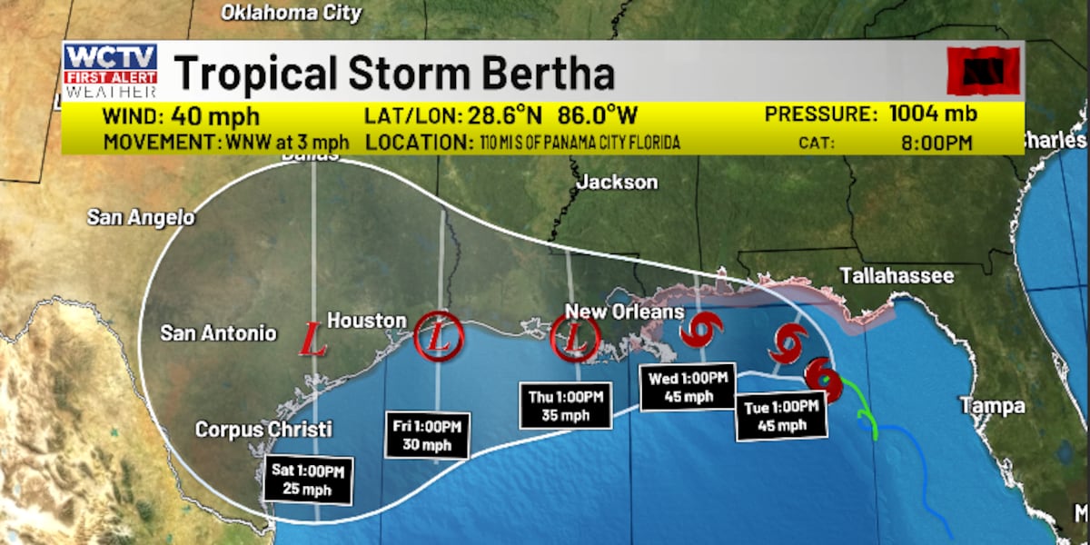
Monday evening, Tropical Depression Two strengthened into Tropical Storm Bertha. The system has maximum sustained winds of 40 mph and a pressure of 1004 mb.
(story continues below)
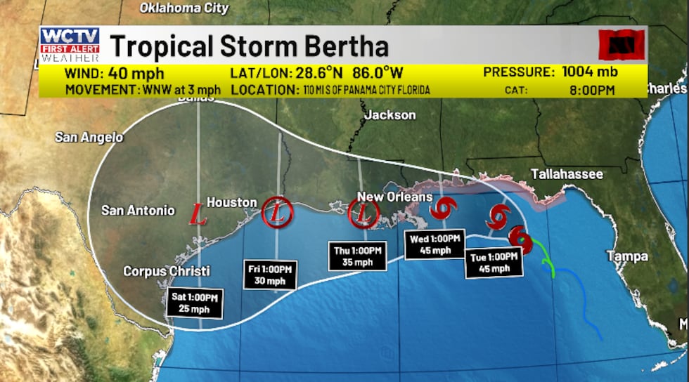 Monday evening, Tropical Depression Two strengthened into Tropical Storm Bertha. The system has maximum sustained winds of 40 mph and a pressure of 1004 mb.(WCTV)
As it skirts near the Louisiana coast, land interaction should help put a cap on how strong this system gets for the second half of the week. It is expected to become a remnant low by Saturday over southern Texas.
This system will likely stay disorganized as it battles some drier air, wind shear and land interaction.
For most of the Big Bend and South Georgia, we have no tropical alerts in place. For coastal Franklin County, a Tropical Storm Watch is in place. This means we could see tropical storm conditions over the next 24-48 hours. We are also tracking a higher risk of rip currents and a rougher surf. We are advising people not to be in the water.
(story continues below)
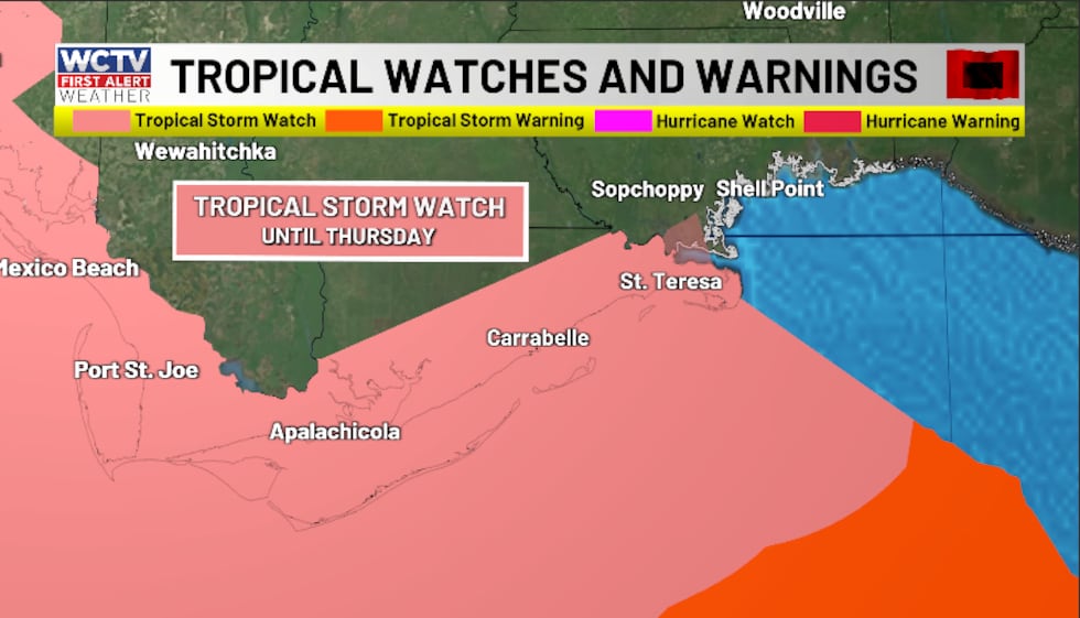 For coastal Franklin County, a Tropical Storm Watch is in place.(WCTV)
Because of a south/southeast wind coming into Apalachee Bay, the National Hurricane Center is mentioning the possibility of some localized storm surge flooding for coastal areas. This does not mean everyone at the coast will see storm surge flooding. However, depending on the wind direction, the shape of the coast and the timing of high tide, some coastal spots could see 1-3 feet of storm surge flooding.
(story continues below)
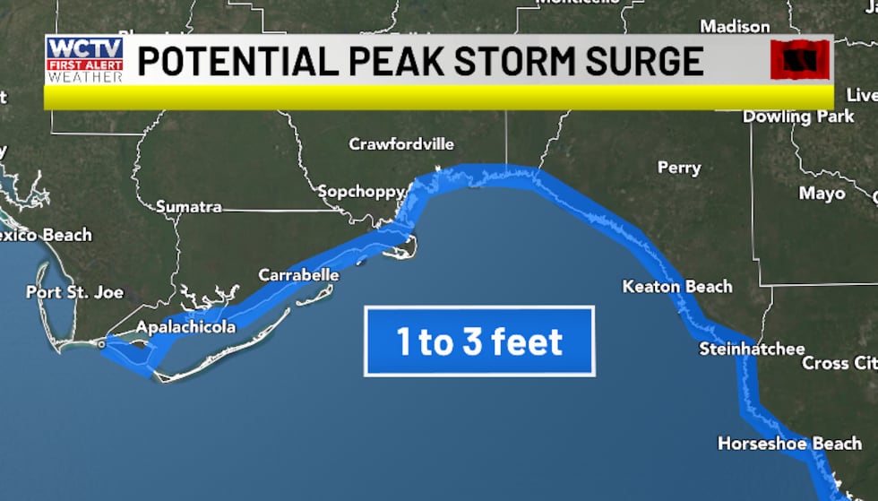 Because of a southerly wind coming into Apalachee Bay, the National Hurricane Center is mentioning the possibility of some localized storm surge flooding for coastal areas. This does not mean everyone at the coast will see storm surge flooding. However, depending on the wind direction and the shape of the coast, some coastal spots could see 1-3 feet of storm surge flooding.(WCTV)
This disturbance will continue pushing tropical moisture into our neck of the woods through midweek. As a result, we are tracking more waves of showers and storms. Some pockets could pick up several inches of rain through the middle of the week. For areas along and south of I-10, we are anticipating 2-4 inches of rain, with locally higher amounts near the coast. North of I-10, we should see 1-2 inches of rain. Still, the rain will not be constant.
Because we stay on the eastern, stormier side of this disturbance, we will have to keep an eye on a few stronger storms. The severe weather threat stays very low, but it is not zero. The main threats are gusty winds and heavy rain, but a few showers could try and show some broad rotation. Again, a very low chance, but stay weather aware just in case.
Local Forecast
Periods of showers and thunderstorms will rotate across the Big Bend and South Georgia on Monday and Tuesday.
Because of the showers and clouds, highs are below average for mid-July. Temperatures hover in the upper-80s to low-90s under a partly sunny sky.
We are also tracking a breezy wind. We could see some gusts up to 20-25 mph on Monday and Tuesday for inland areas. At the coast, winds could gust up to 30-40 mph at times.
Spotty downpours linger into the overnight hours under a partly cloudy sky. Lows stay very muggy as we hover in the mid-70s.
Looking ahead, rain chances are trending lower for the second half of the work week. Spotty downpours are still possible, but the rain coverage is not looking as widespread for Wednesday-Friday. As a result, temperatures will begin to climb. We top out in the low-to-mid-90s under a mix of Sun and clouds.
To stay updated on all the latest forecasts and weather, follow WCTV First Alert Weather on Facebook and X (Twitter).
Click here to see all the latest weather headlines and here to view the First Alert Radar. Receive push alerts and watch the latest forecast anytime on the free WCTV First Alert Weather app. Click here to download it now.
Interested in becoming a WCTV First Alert Weather Watcher? Click here to join the team!
Copyright 2026 WCTV. All rights reserved.