
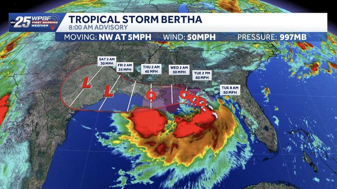
Breaking weather on Bertha, the 5:00 a.m. advisory just dropping in at 5:00 a.m. still 50 mile an hour winds with Bertha Bertha intensifying, strengthening and enlarging here in the Gulf. It’s still about 200 miles to the south and east of Mobile, Alabama, and making *** beeline. It looks like just along the periphery of the northern Gulf Coast states and maybe. Making *** landfall Thursday, this is 2 a.m. over New Orleans might skirt past Mobile Bay and then hit New Orleans and then lose intensity with that interaction with land. But either way, uh, Bertha, *** strong tropical storm and it continues to spin up here. We have tropical storm warnings and watches up across that northern Gulf region, not *** player for us. Got more on how much rain they’ll see, etc. in *** little bit.
Flooding possible as Tropical Storm Bertha moves northwest with 50 mph winds along the Gulf Coast

Updated: 10:04 AM EDT Jul 21, 2026
The National Hurricane Center is tracking Tropical Storm Bertha, which formed Monday night off Florida’s Gulf Coast.As of the 8 a.m. advisory, Bertha was located about 100 miles south-southwest of Panama City, Florida, and about 175 miles southeast of Mobile, Alabama. It was moving northwest at 5 mph with 50 mph maximum sustained winds. Tropical Storm WarningAlabama/Florida border to the Jefferson/Plaquemines Parish border in Louisiana Storm Surge WatchAlabama/Florida Border to the Mouth of the Mississippi River Tropical Storm WatchBay/Gulf County line in Florida westward to the Florida/AlabamabordeWest of the Jefferson/Plaquemines Parish border to Morgan City, LouisianaMetropolitan New Orleans, Lake Pontchartrain, and Lake Maurepas Bertha could make landfall near New Orleans on Thursday, producing heavy rain and up to a 4-foot storm surge.It is forecast to produce rainfall of 2 to 4 inches with locally higher amounts around 8 inches through Friday along the Gulf Coast and adjacent island locations from western Florida to Texas’ middle coast, including southern portions of Alabama, Mississippi and Louisiana.NHC said this rainfall may produce areas of flash flooding, especially in urban areas.Tracking the TropicsArthur was the first named storm of the 2026 Atlantic hurricane season. Arthur reached tropical storm strength on June 17, with winds of 45 mph in the Gulf close to the Texas coastline.Stay with WPBF 25 on-air and online for updates.Interactive radarSevere Weather AlertsDownload the WPBF 25 News app for the most up-to-date weather alerts.
The National Hurricane Center is tracking Tropical Storm Bertha, which formed Monday night off Florida’s Gulf Coast.
As of the 8 a.m. advisory, Bertha was located about 100 miles south-southwest of Panama City, Florida, and about 175 miles southeast of Mobile, Alabama.
It was moving northwest at 5 mph with 50 mph maximum sustained winds.
Tropical Storm Warning
Alabama/Florida border to the Jefferson/Plaquemines Parish border in Louisiana
Storm Surge WatchAlabama/Florida Border to the Mouth of the Mississippi River Tropical Storm WatchBay/Gulf County line in Florida westward to the Florida/AlabamabordeWest of the Jefferson/Plaquemines Parish border to Morgan City, LouisianaMetropolitan New Orleans, Lake Pontchartrain, and Lake Maurepas
Bertha could make landfall near New Orleans on Thursday, producing heavy rain and up to a 4-foot storm surge.
It is forecast to produce rainfall of 2 to 4 inches with locally higher amounts around 8 inches through Friday along the Gulf Coast and adjacent island locations from western Florida to Texas’ middle coast, including southern portions of Alabama, Mississippi and Louisiana.
NHC said this rainfall may produce areas of flash flooding, especially in urban areas.
Tracking the Tropics
Arthur was the first named storm of the 2026 Atlantic hurricane season. Arthur reached tropical storm strength on June 17, with winds of 45 mph in the Gulf close to the Texas coastline.
Stay with WPBF 25 on-air and online for updates.
Download the WPBF 25 News app for the most up-to-date weather alerts.