
Hot air settles back in as rain coverage drops across Central Florida
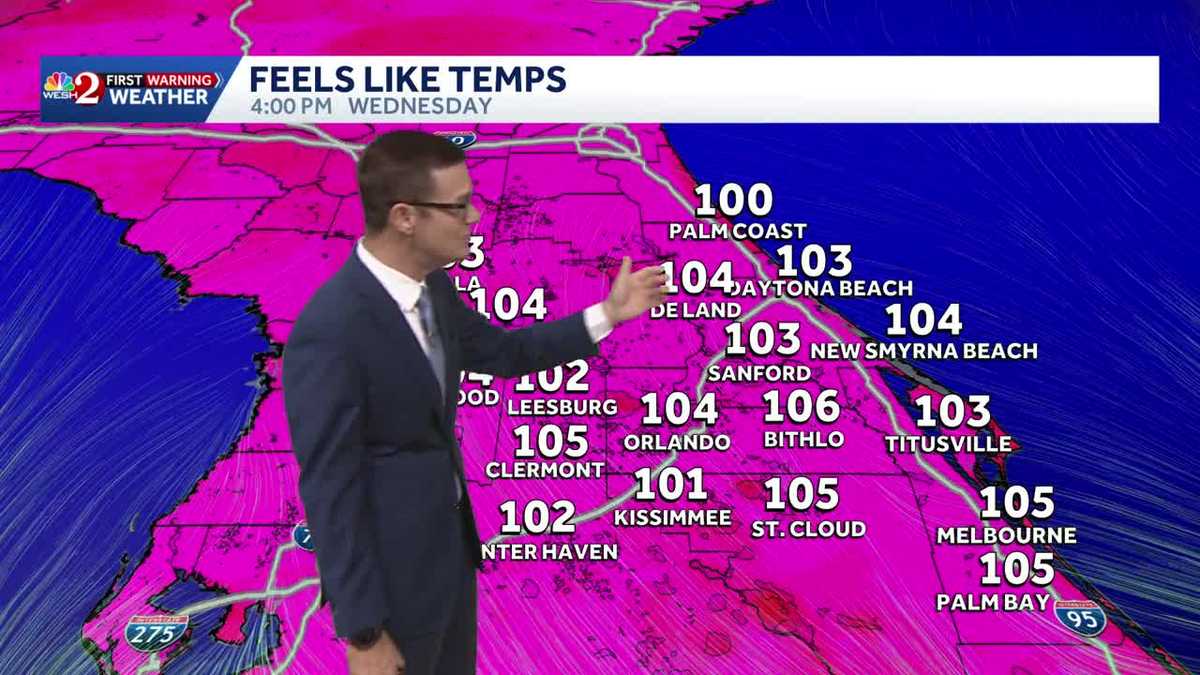
And first, warning meteorologist Eric Burch joining us now doing just that, tracking what’s happening in the Gulf right now with Bertha and Bertha’s kind of heading in that direction. When I was talking about it earlier, I even said star base, having no recollection of the timing of all this. I don’t know if we’re going to have great weather for it, just being honest, even if it is *** sheer weak tropical storm, it is still *** tropical storm, right? Moving to the west now at just above *** snail’s pace, we’ll say it’s at 5 miles an hour motion. Winds are at 50, peaked out yesterday with 60 mile per hour winds. The center of. is way up here. Notice all the convection down here because of *** whole lot of wind shear coming on through. So over the course of the day today out near Grand Isle or the Wrigley, it’ll cross through South New South New Orleans, South Louisiana, then eventually move back out over water and then head over toward coastal Texas from anywhere, say Houston, Galveston all the way down toward Brownsville. So we’ll have to watch and see. But either way, on the backside of Bertha, it’s throwing *** hole. *** lot of humidity in our direction and frankly allowing our temperatures to heat up for today it’s 96. The record is 97. Then for tomorrow we hit 97. The record is 98. So there’s going to be *** couple of day stretch here where our temperatures are going to be climbing, and that’s just the air temperature. We look to the feels like temps and once again we get into the triple digits. I’ll add though, we’re not to heat advisory territory. That’s 108. We do stay shy of that, but it’s still going to feel hot enough. 10. 4 in Orlando feels like 105 in Claremont, 103 for us in Ocala. So it is *** great day to take the kids or yourself, get into the backyard swimming pool. We’re staying mostly dry and it’s going to be hot. 96 degrees, our high temperature. If you’re playing golf today, weather impact is going to be low. Obviously there’s *** breeze to deal with. There’s *** hot sun, so UV rays, we need to keep hydrated and use sunscreen, that sort of *** thing. Looking ahead to the weekend just to help you plan, I know that it’s. Only Wednesday, but here we are. Um, we are going to be hot, right, mid to even upper 90s, but we do add in that 40% coverage of showers and storms. So at least that’s going to help us out *** little bit. All right. Outside we go to *** beautiful shot of Lake Monroe, one of the emergency vehicles doing whatever they’re doing, but it’s *** beautiful start weather-wise here. Uh, temperatures into the upper 70s for most of us. First warning live radar is nice and quiet. Through the day today, we’ll see *** few passing showers, not much more than that. The newest run of Futurecast though is showing about 8, 8:30, 9 o’clock. *** bit of *** sea breeze collision in our western areas. I’ll have to watch and see if that stays consistent. If that messaging stays consistent, I may have to nudge this from *** 10% coverage of rain to *** 20% coverage of rain. But either way, mostly dry today. Same thing tomorrow, then notice Friday, Saturday, Sunday we start to pick up that rain coverage and while yes, it’s going to be hot, at least we’ll have some of those cooling storms to help us out and then into next week that rain coverage continues to grow.
Hot air settles back in as rain coverage drops across Central Florida

Updated: 5:58 AM EDT Jul 22, 2026
Hotter air is building back into the region as rain chances continue to decrease.Expect mostly dry conditions Wednesday, with a high near 96 degrees. That warmer pattern is expected to hold through the next few days, with temperatures climbing to around 97 in the metro area.A shift may arrive next week as rain coverage begins to increase again. That should help bring temperatures back down somewhat and keep the heat in check.In the tropics, Bertha continues moving west, away from our area and along the northern Gulf Coast. The system is expected to keep weakening as it moves farther from us.First Warning Weather Stay with WESH 2 online and on-air for the most accurate Central Florida weather forecast.RadarSevere Weather AlertsDownload the WESH 2 News app to get the most up-to-date weather alerts. The First Warning Weather team includes First Warning Chief Meteorologist Tony Mainolfi, Eric Burris, Marquise Meda, Cam Tran and Victoria Wisniewski.
ORLANDO, Fla. —
Hotter air is building back into the region as rain chances continue to decrease.
Expect mostly dry conditions Wednesday, with a high near 96 degrees. That warmer pattern is expected to hold through the next few days, with temperatures climbing to around 97 in the metro area.
A shift may arrive next week as rain coverage begins to increase again. That should help bring temperatures back down somewhat and keep the heat in check.
In the tropics, Bertha continues moving west, away from our area and along the northern Gulf Coast. The system is expected to keep weakening as it moves farther from us.
This content is imported from Twitter.
You may be able to find the same content in another format, or you may be able to find more information, at their web site.
Tropical Storm Bertha is 50 miles northeast of the Mississippi River mouth, still at 50 mph and drifting west. The warning east of the Okaloosa/Walton line is dropped. Warnings still cover the Okaloosa/Walton line west to Morgan City, metro New Orleans, and Lake Pontchartrain. pic.twitter.com/9U1SskY0DW
— Eric Burris (@EricBurrisWX) July 22, 2026
First Warning Weather
Stay with WESH 2 online and on-air for the most accurate Central Florida weather forecast.
Download the WESH 2 News app to get the most up-to-date weather alerts.
The First Warning Weather team includes First Warning Chief Meteorologist Tony Mainolfi, Eric Burris, Marquise Meda, Cam Tran and Victoria Wisniewski.