
Temps continue warming up in Central Florida before big cool down
PEOPLE NEED AS MUCH HELP AS THEY CAN GET. ALL RIGHT. NOW LET’S TURN TO OUR LOCAL FORECAST BECAUSE IT FEELS GREAT OUT THERE THIS MORNING. WE CAN ALL AGREE, BUT ENJOY IT. YEAH. BECAUSE SOMETHING IS ON THE WAY. OH, YEAH. WHAT IS THAT? WINTER IS COMING. I KNOW THIS IS THE SEASON WHERE IT’S JUST UP AND DOWN, RIGHT? RIGHT. IT’S YOU KNOW, WHAT IT IS IS IT’S LIKE FALL IS NOW FULLY IN. YEAH. AND THEN IT’S TIME TO CONTINUE BUILDING THAT. SO YES, LET’S TALK ABOUT WHAT WE’RE TRACKING IN THE WEATHER CENTER THIS MORNING, BECAUSE IT IS A VERY BUSY MORNING. TAKE A LOOK. NEXT COUPLE OF DAYS WE CONTINUE WARMING. SO FOR THOSE THAT LIKE IT HOT GIDDY UP. YOU’RE GOING TO ENJOY THAT. BUT THEN SUNDAY INTO MONDAY COLD FRONT WILL BE WORKING IN THUS WILL NEED THE UMBRELLAS. WE’LL HAVE TO WATCH THE RADAR BECAUSE THE COLDEST AIR WE HAVE SEEN SINCE FEBRUARY IS MOVING IN BY TUESDAY. TAKE A LOOK AT THE SEVEN DAY FORECAST. ALL RIGHT. FOR TODAY. FOR TOMORROW. LOTS OF CLOUDS WITH US, TEMPERATURES CLIMBING INTO THE MID RANGE. THE 80S. WE’LL EVEN ADD IN A FEW SHOWERS AND THEN BOOM GOES THE DYNAMITE. THOSE TEMPERATURES DROP OFF IN A BIG, BIG WAY. SO HERE’S THE SETUP. OUR HIGH PRESSURE HAS BEEN SINKING SOUTH. AND WHAT THAT’S BEEN DOING IS WARMING UP OUR TEMPERATURES BY TOMORROW. IT HELPS TO BRING IN A FEW SHOWERS. WATCH FUTURECAST TO TAKE YOU THROUGH. THIS IS THIS AFTERNOON. MOSTLY CLOUDY SKIES OVER TOP OF US, BUT LOOK INTO TOMORROW MORNING ALREADY WITH A FEW SHOWERS THAT WILL LINGER THROUGH THE AFTERNOON. NOTHING STRONG OR SEVERE, BUT WE MAY HAVE A FEW SHOWERS TO DEAL WITH. THEN, LOOKING AHEAD TO OUR SATURDAY, STARTING OFF WITH SUNSHINE. EVEN A LITTLE BIT OF FOG, PERHAPS UP TO THE NORTH, BUT ALMOST A SUMMERS PATTERN WHERE WE GET THE SEA BREEZE IS GOING BECAUSE IT’S GOING TO BE A HOT ONE. SATURDAY’S FORECAST HIGH TEMPERATURE IS 86 DEGREES. NOW THE RECORD IS 89, SO WE’LL AT LEAST BE IN THE BALLPARK THERE. BUT THAT SHOULD LET YOU KNOW HOW HOT WE GET. THEN AFTERWARD, WE START TO WATCH OUR NEXT WEATHER MAKER THIS COLD FRONT APPROACHING. AND AS IT DOES, IT BRINGS IN SHOWERS, MAYBE EVEN A THUNDER SHOWER ON SUNDAY. BUT REALLY DROPS THE TEMPERATURES BY MONDAY AND TUESDAY. FOR EXAMPLE, VETERANS DAY. IT’S FEELING LIKE WINTER WITH TEMPERATURES IN THE METRO IN THE 40S AND DAYTIME HIGHS ONLY MAKING IT INTO THE 60S. LOOK AT OUR TUESDAY MORNING 42 IN ORLANDO, 37 DEGREES IN THE VILLAGES AND 43 IN DELAND. AND YOU FACTOR IN THE WINDS AND IT FEELS EVEN CHILLIER THAN THIS. WE’LL TALK MORE ABOUT THAT IN THE NEXT HALF HOUR’S TIME. BUT IN THE MEANTIME, WE’RE ENJOYING THIS COMFORTABLE SETUP. SO FOR EXAMPLE, UCF HAS THE FOOTBALL GAME. IT’S THE BIG GAME FRIDAY. TEMPERATURES WILL BE IN THE 70S, AND IT MAY NOT FEEL LIKE IT’S TIME TO FLIP FOR CHRISTMAS. BUT SEAWORLD, OUR RADIO PARTNER, MAGIC 177, IS DOING THE BIG FLIP ON FRIDAY. AND WHILE IT’S MILD, MAYBE IT’S THEIR FLIP THAT’S MAKING THE BIG FLIP IN OUR TEMPERATURES, BECAUSE JUST AFTER WE GO FULL ON WINTER, CENTRAL FLORIDA CERTIFIED MOST ACCURATE SEVEN DAY FORECAST, SHOWING THAT WARM
Temps continue warming up in Central Florida before big cool down

Updated: 6:34 AM EST Nov 6, 2025
Today promises to be a comfortable and dry day, with temperatures expected to reach around the lower 8os. Friday into the weekend, temperatures will start climbing, and a few showers will return to the forecast. By Sunday, the next major cold front will approach, bringing a significant chill to the region early next week, with highs in the 60s and morning lows in the 30s and 40s.First Warning Weather Stay with WESH 2 online and on-air for the most accurate Central Florida weather forecast.RadarSevere Weather AlertsDownload the WESH 2 News app to get the most up-to-date weather alerts. The First Warning Weather team includes First Warning Chief Meteorologist Tony Mainolfi, Eric Burris, Marquise Meda and Cam Tran.
ORLANDO, Fla. —
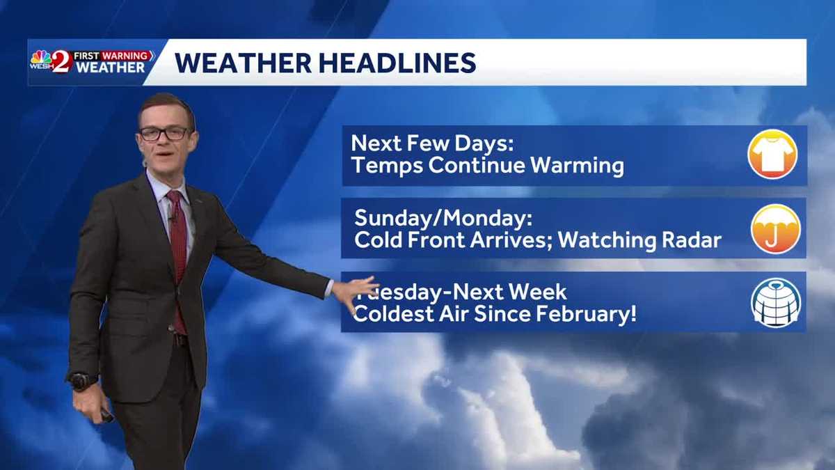
Today promises to be a comfortable and dry day, with temperatures expected to reach around the lower 8os.
Friday into the weekend, temperatures will start climbing, and a few showers will return to the forecast.
By Sunday, the next major cold front will approach, bringing a significant chill to the region early next week, with highs in the 60s and morning lows in the 30s and 40s.
First Warning Weather
Stay with WESH 2 online and on-air for the most accurate Central Florida weather forecast.
Download the WESH 2 News app to get the most up-to-date weather alerts.
The First Warning Weather team includes First Warning Chief Meteorologist Tony Mainolfi, Eric Burris, Marquise Meda and Cam Tran.