
Partly cloudy with an isolated shower chance for South FL
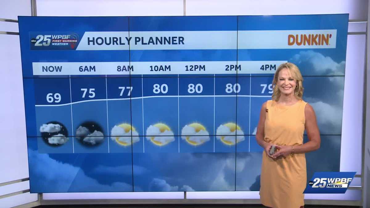
OUT THE DOOR YASMINE WATCHING TRAFFIC. LET’S START WITH SANDRA AND THAT FORECAST. AND I LIKE MY MULTICOLORED MAP HERE. OF COURSE WE SEE THE COLD AIR WELL TO OUR NORTH OVER THE SOUTHERN STATES. WE’VE GOT A TOUCH MORE AND MORE MOISTURE. WE WERE IN THE YELLOW EARLIER THIS WEEK, SO SOME GREEN KIND OF HEADING IN FOR TOMORROW AND THROUGHOUT THE WEEKEND. SO A SLIGHT CHANCE OF SHOWERS TOMORROW. YOU SEE THE CONTOURS CHANGING WITH MORE RED AS WE HIT SATURDAY. NOW SUNDAY WE HAVE A STRONG FRONT THAT WILL BE ON THE MOVE MONDAY. IT GETS THROUGH HERE TUESDAY MORNING. HOW ABOUT WAKING UP INTO THE 40S ON SPOTS OF THE TREASURE COAST? IT LOOKS LIKE IT’S ON THE HORIZON, BUT THAT’S FAST FORWARDING. TODAY WE’RE GOING TO BE SEASONABLE. WE’RE IN THE 60S ON THE TREASURE COAST NOW, 60 TO 70 DEGREES RIGHT AROUND THE PALM BEACHES. WANT TO TAKE A LOOK AT OUR SKY CAMERA HERE IN BOCA? AND YOUR DAY PLANNER GIVES US THE LOW 80S WITH KIND OF VARIABLY CLOUDY SKIES. MAYBE A SHOT OF A SHOWER AT ABOUT 3:00 THIS AFTERNOON. AS WE ADVANCE THROUGH THE TREASURE COAST, WE’RE GOING TO SEE A SIMILAR SITUATION. NICE SUNRISE EARLY ON AT ABOUT 630 AND THEN SOME CLOUDS AND MAYBE A SHOWER AGAIN TODAY WITH THE LOW 80S ON THE HORIZON. TAKING A LOOK AT YOUR DAY PLANNER. IT SHAPES UP LIKE THIS. VARIABLY CLOUDY TO PARTLY SUNNY SKIES, WITH A SLIGHT CHANCE AT ABOUT 20% OF SEEING
South Florida will see partly sunny skies today with highs hitting seasonable readings in the lower 80s. There’s a better chance for some showers tomorrow afternoon. The weekend will be warmer with highs from 84 to 87 degrees. A vigorous cold front will move through, starting Sunday and clearing the area Monday night. That will mean lows in the 40s and 50s on Tuesday morning with impact weather for the chill.
South Florida will see partly sunny skies today with highs hitting seasonable readings in the lower 80s. There’s a better chance for some showers tomorrow afternoon. The weekend will be warmer with highs from 84 to 87 degrees. A vigorous cold front will move through, starting Sunday and clearing the area Monday night. That will mean lows in the 40s and 50s on Tuesday morning with impact weather for the chill.