
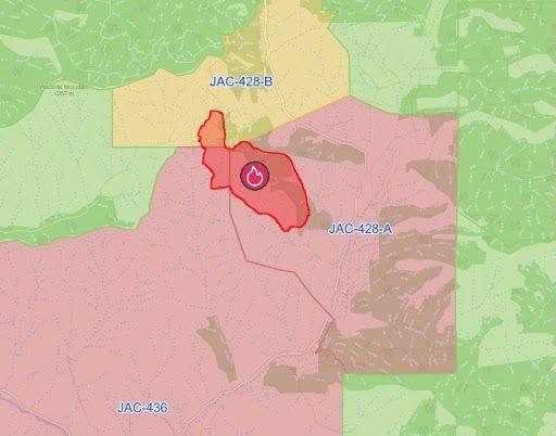
Fire is an estimated 282 acres after Friday morning drone mapping; Level 3 evacuation notices downgraded
8:34 p.m update: Firefighters strengthened control lines and completed 25 feet of mop-up around the entire perimeter of the Woodrat Mountain Fire on Friday despite hot, windy conditions and critical fire weather, the Oregon Department of Forestry Southwest District said in an evening post.
The fire is now 10% contained and remains mapped at 282 acres.
The fire is 100% hose lined, ODF-Southwest said, providing water access around the entire perimeter as firefighters extinguish hot spots and secure lines.
“Ground and aviation resources worked in tandem throughout the day, with helicopters supporting crews through water bucket drops. Aircraft will continue flying this evening as long as daylight allows,” the post said.
“As operations transition into the night shift, incoming resources will take over suppression work across the incident,” fire officials said.
The south side of the fire will have three 20-person hand crews, three engines and one water tender, while the north side will have three 20-person hand crews, two engines and one water tender, according to ODF-Southwest.
Email newsletter signup

On the eastern side, where steep terrain and thick vegetation make suppression work more challenging, one 10-person hand crew, two 20-person hand crews, two engines and two water tenders are assigned.
4 p.m. update: Jackson County Emergency Management says the American Red Cross shelter at Jacksonville Elementary School will be closing as evacuation needs from the 282-acre Woodrat Mountain Fire continue to decrease.
“Jackson County extends its sincere appreciation to the American Red Cross for providing shelter and support to residents displaced by the fire,” a Friday afternoon emailed statement said.
Additionally, road closures associated with the incident are expected to be reopened at 6 p.m. Friday (see current road closure information below).
“Motorists are encouraged to drive cautiously as emergency personnel and utility crews may still be working in the area,” the release said.
Residents living within evacuation areas should continue to stay informed, remain prepared, and follow directions from public safety officials, as fire conditions can change quickly, Emergency Management said.
You can view Genasys Project to find evacuation zones for the fire at protect.genasys.com.
12:30 p.m. update: The Jackson County Sheriff’s Office announced that all Level 3-Go Now evacuation levels have been downgraded to Level 2-Be Ready for the Woodrat Mountain Fire.
JAC-428A and JAC-428B will revert back to one zone, JAC-428, and be at a Level 2-Be Ready status, along with JAC-436.
View previous coverage below:
Firefighters completed a line around the Woodrat Mountain Fire Thursday night, the Oregon Department of Forestry Southwest announced Friday morning.
The fire is currently at 282 acres, the ODF release said, with drone mapping providing a more accurate number than the past 300-acre estimate. Crews made “significant progress” overnight despite poor relative humidity. Bulldozers constructed much of the line, according to ODF, while hand crews worked through the areas where steep terrain and dense timber limited heavy equipment access.
The fire is 60% hose lined as of the Friday morning update, which brings water access to much of the fire’s perimeter.
“Today, firefighters will focus on improving existing lines, extending hose and identifying remaining heat,” the Friday release read.
“Night shift crews were aware of potential hot spots outside the eastern side of the perimeter and gridded and searched those areas overnight but did not locate additional heat to extinguish. Crews will continue checking those areas today.”
The release said a “strong” air response is planned for the fire on Friday, with four Type 1 helicopters, three Type 2 helicopters and two Type 3 helicopters available for water bucket drops as needed. Air tankers are also available for retardant drops. You can read more about firefighting helicopter types here.
According to ODF Southwest, resources positioned for the fire include four 20-person hand crews, two dozers and two water tenders each on the south, north and eastern sides of the fire. Both the north and south sides have a falling module, which is a team of highly qualified tree fallers, while the east side has two. Additionally, the south side has three engines, the north side four and the east side five.
The ODF release said the eastern side of the fire features “steep terrain and thick vegetation.” Resources are positioned across the fire based on terrain and operational needs.
“Although the entire perimeter is lined, firefighters still have extensive work ahead in steep terrain, dense timber and areas with hazardous snags,” the release said. “Another day of critical fire weather is expected, making today’s work especially important as crews secure the fire while resources remain ready to respond to any new fire starts across the district.”
Evacuations
Jackson County Sheriff Oregon and Jackson County Emergency Management have issued Level 3–Go Now, Level 2-Be Set and Level 1-Be Ready evacuation notices for areas affected by the fire. Current evacuation information and maps are available at rvem.org/fires.
You can view Genasys Project to find evacuation zones for the fire: protect.genasys.com.
Level 3: All notices downgraded
Level 2: JAC-428 JAC-436
Level 1: JAC-421 JAC-422 JAC-423 JAC-427 JAC-429 JAC-434 JAC-437 JAC-438
Road closures
Griffin Lane at Sterling Creek Road, Little Applegate Road at Sterling Creek Road and Little Applegate Road at Upper Applegate Road are closed, according to the Jackson County Sheriff’s Office.
These roads are only open for those working the fire, and residents.
According to the Emergency Management press release, road closures associated with the incident are expected to be reopened at 6 p.m. Friday.
Shelter
The American Red Cross shelter at Jacksonville Elementary School will be closing as evacuation needs continue to decrease, Emergency Management said in a Friday press release.
Individuals needing additional medical care or sheltering assistance can call 541-776-7206.
Livestock can still be taken to the Jackson County Expo, 21 Peninger Road in Central Point; call 541-864-0546 for livestock assistance.
Origin
According to the ODF release, the fire was first reported just before 12:45 p.m. Thursday, Aug. 6, when firefighters were dispatched to a vehicle fire spreading into surrounding vegetation on Bureau of Land Management (BLM) land along Woodrat Mountain Road near Ruch.
ODF Southwest District, Jacksonville Fire Department and Applegate Valley Fire District began an aggressive initial attack, with additional ground and air resources ordered as the incident grew.
Numerous partnering agencies from across the Rogue Valley and surrounding area responded Thursday, the release said, including Applegate Fire District, Jacksonville Fire Department, Jackson County Fire District 3, Medford Fire Department, Grants Pass Fire, Rural Metro Fire – Josephine County, Illinois Valley Fire District and the U.S. Forest Service- Rogue River-Siskiyou National Forest.
The official cause of the Woodrat Mountain Fire remains under investigation, the ODF release said.
Temporary Flight Restriction (TFR)
A Temporary Flight Restriction (TFR) remains in effect over the fire area until further notice. Flying a drone near a wildfire is illegal and can force firefighting aircraft to leave the area, putting firefighters and the public at risk, ODF announced.
Ryland Bickley is a 2026 Snowden intern for the Rogue Valley Times. Reach him at 458-488-2040 or ryland.bickley@rv-times.com.