
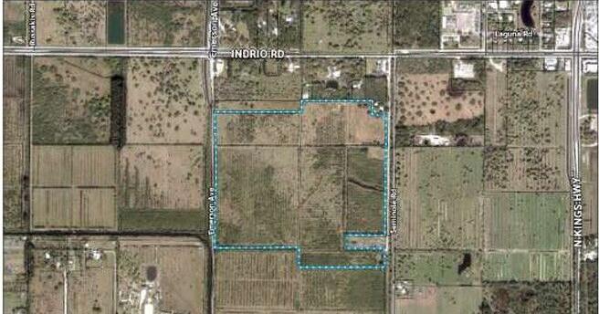
FORT PIERCE – The proposed Towns, Villages & Countryside Overlay development known as the Club at Indrio Creek finally got a majority recommendation of approval from the St. Lucie County Planning & Zoning Commission on Aug. 20 after being tabled the previous month due to ongoing differences between staff and the applicant over code compliance issues.
The presentations by both that evening, however, revealed they were still at odds over three of the 12 conditions of approval.
Senior Planner Irene Szedlmayer reintroduced the item during the latest meeting.
“You’re familiar with the 126-acre site located south of Indrio Road between Emerson Avenue and Seminole Road,” she said. “It is in the AG-1 Zoning District – which permits one dwelling unit per acre – in the Towns, Villages & Countryside Future Land Use Category and in the Urban Services Boundary. As you know, the Transferable Development Value Map is a very important document in the Towns, Villages & Countryside Overlay. It brought forward the residential densities on the land at that time, the majority of [which] has a base density of one dwelling unit per acre.”
According to the TDVM, developers can request density bonus multipliers for open space dedicated as either countryside or restored habitat, which can significantly increase the number of proposed housing units. Szedlmayer noted that the previous total of 375 units had dropped to 365 in the interim due to renegotiations since the July 15 meeting.
“They’re proposing two civic building lots, two community recreation areas, a new east-west public street that will connect Seminole and Emerson [and] providing about 66 acres of open space,” she explained. “Most of that 66 acres does qualify as countryside, which means they are eligible for a 1.75 density multiplier. They are dedicating 2.9 acres of right of way for Emerson Avenue and are constructing a small segment of that road at the northern end, and they are constructing most of the spine road.”
After going through details of the preliminary development plan and changes occurring over the previous month, Szedlmayer listed several reasons she could not recommend approval. Those included issues with the project’s internal street connectivity and block sizes; external street connectivity; street and alley design; eligibility for the countryside and restored habitat open space designations; and the fact that workforce housing had not been identified on the plan. She concluded with staff’s conditions of approval.
The applicant’s contracted Landscape Architect Brad Currie came to the podium afterward and expressed dismay that staff still opposed so much of his preliminary development plan.
“Tonight I’m representing the applicant’s request to rezone approximately 127 acres in the TVC to planned town or village,” he said. “I had a very good meeting with staff yesterday. Believe it or not, I thought I was going to come to this meeting and say we only had three issues to go over. It seems like we’re pretty far apart. Hopefully after my presentation, you can see that we are much closer than what staff’s presentation just was.”
Currie referred to the TVC Overlay as “the most difficult zoning code” he had worked with over his 26-year career.
“It is interpreted different ways by different people,” he continued. “Most zoning applications like this are a negotiation, and I think the TVC is no different. It’s a difficult code: In some cases staff is okay with us not meeting the complete intent; in other places, staff is forcing us to meet the intent of the code. So, it’s kind of a give and take. I want to make sure everyone’s aware that this property is clearly inside the Urban Services Area, and it’s intended for development and what we are doing.”
Currie acknowledged that following the TDVM’s density formulas was no easy task, as Szedlmayer nos disputed some of his countryside designations.
“Our property has a split designation,” he explained. “The northern property is 108 acres at two units per acre, and the southern property is one unit per acre. I sent an email this afternoon to Mr. [Kori] Benton and said that we need to discuss how we’re going to handle the density because, every time I blink, the density changes. As you can imagine from staff’s presentation, you move one square foot of countryside or restored habitat and it has an impact on the density.”
His primary complaint, however was on the condition requiring his client to pave a portion of Seminole Road and bring it up to county standards. Planning Manager Benton later confirmed that idea was briefly touched upon in a pre-application meeting last year, with Currie lamenting the fact it had not been mentioned again until last June.
“The kicker here is, we didn’t get the comment about Seminole Road until two months ago,” he fumed. “That’s a multimillion-dollar deal-killer, and we were in the process for over a year when we got that comment. That is extremely unreasonable. I try to be reasonable, but no, I wouldn’t be here tonight if I had known that Seminole Road was a requirement last May.”
The rest of the discussion centered around P&Z commissioner questions and staff and the applicant’s responses. Most of the inquiries directed at Currie and the applicant’s contracted Land Use Attorney Bob Raynes centered around their rejection of that requirement. The former pointed out that the primary access was on Emerson and only an emergency entrance was slated for Seminole, a chip-sealed roadway. The applicant must also build an east-west roadway to comply with TVC requirements.
“There’s a few of the conditions of approval that we would like changed,” he explained. “The first one, of course, is the access and paving of Seminole. We simply can’t do that. If that’s going to be a requirement, we’re not sure the project will move forward. We are in agreement to an emergency access to Seminole because that doesn’t require us to improve the roadway. Secondly, we think the multiplier for the countryside between townhomes is something we should get benefit for; and we think we should get credit for the multiplier on the entire 35 feet of the perimeter buffer.”
Later on when Board Member William O’Dell believed the development lacked internal roadway connections and attempted to convince Currie of the need to connect to Seminole, the latter called Traffic Engineer Shaun MacKenzie to the podium.
“This site does not connect to Seminole Road,” MacKenzie said. “This site has five different entrances to a county collector roadway network that goes out onto Emerson Avenue. That’s a collector arterial roadway, which ends at a traffic signalized intersection with Indrio Road, a very safe access point for all of the future residents. We certainly meet every criteria of the code.”
Currie in turn believed his client was being treated differently than those of three nearby development projects already approved.
“When you look at those three, none of them had to build the road that’s on the TVC map throughout their entire property line,” he insisted. “We are completely consistent with what’s been previously approved by this Board and also by the Board of County Commissioners. So, what you’re expecting us to do is the opposite: It’s not consistent with what’s been done in the past.”
Those pleas ultimately fell on the deaf ears of the P&Z Commission, whose majority voted 5-1 to recommend approval with all of staff’s conditions of approval intact. Vice-Chairman Lawrence “Beau” Slay – who cast the lone dissenting vote – had earlier given Currie a brief compliment.
“There’s a lot of hypotheticals going on,” he said shortly before the vote. “I applaud you for trying to make this work though.”
At press time, the Hometown News could not confirm the date of the County Commission hearing.