
TALLAHASSEE, FL (WTXL) — Update
Aug. 30, 8 p.m.
Invest 97L
Development chances rise again as it continues to organize.
Next 48 hours: 70% chance of development
Next 7 days: 70% chance of development
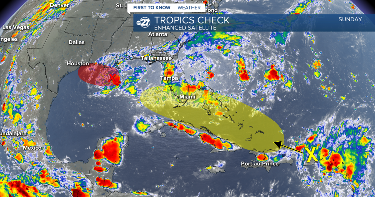
The wave is starting to show signs of organization and circulation as it slowly moves west-northwest. A short lived tropical depression or tropical storm is likely as it moves towards the coast of Louisiana and east Texas.
Remnants of Tropical Storm Dolly
Development chances remain the same as Puerto Rico and parts of the Virgin Islands are getting in on heavy downpours and gusty winds.
Next 4 hours: 0% chance of development
Next 7 days: 20% chance of development
Aug. 30, 2 p.m.
Invest 97L
Development chances have risen with the wave as it is slowly showing signs of organization.
Next 48 hours: 50% chance of development
Next 7 days: 50% chance of development
The most we saw with this low is rainfall throughout Friday and Saturday. However, now that it is moving west and will continue to do so, no further local impacts are expected. If development occurs, coastal Louisiana and east Texas will be impacted.
Remnants of Tropical Storm Dolly
A slight rise in development chances as the remnants of Dolly are hanging on.
Next 4 hours: 0% chance of development
Next 7 days: 20% chance of development
As the cluster of showers and storms move northwest, there will be a small window for development over the next week as it moves into slightly more favorable conditions. Long range models continue to not 100% agree on the track once it reaches the Bahamas. Some keep it over the Bahamas and some move it into the Gulf. In order to move into the Gulf and maintain its strength, it would be a thread the needle situation as it would have to move over the waters between south Florida and Cuba. Overall, if development occurs, the system will most likely stay on the weaker side. We will continue to closely monitor it, but as of now, we are not concerned for local impacts.
ORIGINAL
Aug. 29; 2 p.m.
Two tropical waves are worth the watch through the next week, however, there are no concerns for the Big Bend or south Georgia at this time.
Invest 97L
The first area is currently in the northern Gulf as a weak low pressure system and has been designated ‘Invest 97L’ by the National Hurricane Center Saturday afternoon. It is actually part of what we can thank for the rainfall Friday, Saturday, and parts of Sunday as it is pushing in showers from the south along the coast.
Next 48 hours: 0% chance of development
Next 7 days: 20% chance of development
The local showers we are having through the weekend is the most we will see from this because if development does occur, it will be moving in the westward direction and will not have much room to gain strength.
Tropical Storm Dolly Remnants
Currently located east of the Leeward Islands, the remnants of the short lived Tropical Storm Dolly continue to fire off convection within. Tropical Storm Dolly lost its closed circulation Friday and is struggling to get it back.
Next 48 hours: 0% chance of development
Next 7 days: 10% chance of development
A mix of shear and drier air broke Tropical Storm Dolly up, and now the remnants will have the face more shear as it slowly moves northwest. Down the line, organized development is not expected with the cluster of showers and storms. The Leeward Islands, Virgin Islands and Puerto Rico can expect heavy downpours and gusty winds within the next few days.
Overall, local impacts are not expected with either of these waves. They will remain something to closely monitor over the course of next week.
Want to see more local news? Visit the WTXL ABC 27 Website.
Stay in touch with us anywhere, anytime.