
SARASOTA, Fla. (WWSB) – If you’re already pulling your jacket out of the closet (yes, in Florida), you’re not imagining it, a dramatic early-season cooldown is headed our way for the Suncoast.
Sunshine, palm trees and 80° highs are about to give way to brisk winds, chillier nights and a weather story you’ll want to share.
What’s happening
A strong cold front is diving south out of Canada and pushing into our region by Monday night into Tuesday, with drier, colder air slamming in behind it.
Temperatures that have felt more like early summer will be replaced with a crisp bite in the air. Meteorologists are comparing this to one of the coldest early Novembers in the Southeast in years.
Coastal vs. Inland: Tonight into SundayTonight: Partial clouds, low chance of a sprinkle (10-20%). Low around 70° near the coast with the usual south winds.Sunday: Mostly sunny, high near 82° at the coast, slightly cooler inland. Afternoon/evening storms take a 30% shot inland, about 30% for the coast late day.Key difference: The coast will hold onto warmth a little longer due to the Gulf’s moderating effect; inland will feel the first hints of the front sooner.Monday into Mid-Week: The Real ChillMonday: High near 72° at the coast, maybe upper 60s inland. Winds ramp up (WNW 15-20 mph, gusts near 30 mph).Monday Night: That’s where the real drama hits. Lows dropping into the 41° range on the coast, upper 30s inland north of Manatee County.Record talk: The all-time Sarasota low is 20°F set in December 1983. While we’re not going there, we are flirting with cold numbers that just don’t happen often this early in November.Tuesday & Wednesday: Highs struggling in the 50s–60s, lows slipping into 30s–40s. That’s the coolest sweep of air we’ve seen so far this fall.Tropics: Quiet for Now
The tropics remain calm, with no systems expected to develop in the next 7 days. Bottom line: your phone’s hurricane icon can stay in its pocket, maybe for the season.
Boating & Beach UpdateLate Sunday into Monday: Boating conditions start to sour. Winds shift to the north-west, seas build, expect choppy waters and higher risk for rip currents along the Gulf side.Mid-week onward: As high pressure builds behind the front, conditions improve for calmer surfing and boating (but bundle up!).Fun Sky-Watch / Nature NotesWith the clear, crisp air moving in, star-seeing gets a boost Tuesday night into Wednesday.The Leonid meteor shower peaks Nov 17-18, fewer clouds and crisper air = prime viewing for the Suncoast skies.Tropical note: Watch for fallen iguanas! During rapid deep drops (below 50°F), they can become stunned. (Yes, Florida quirks!)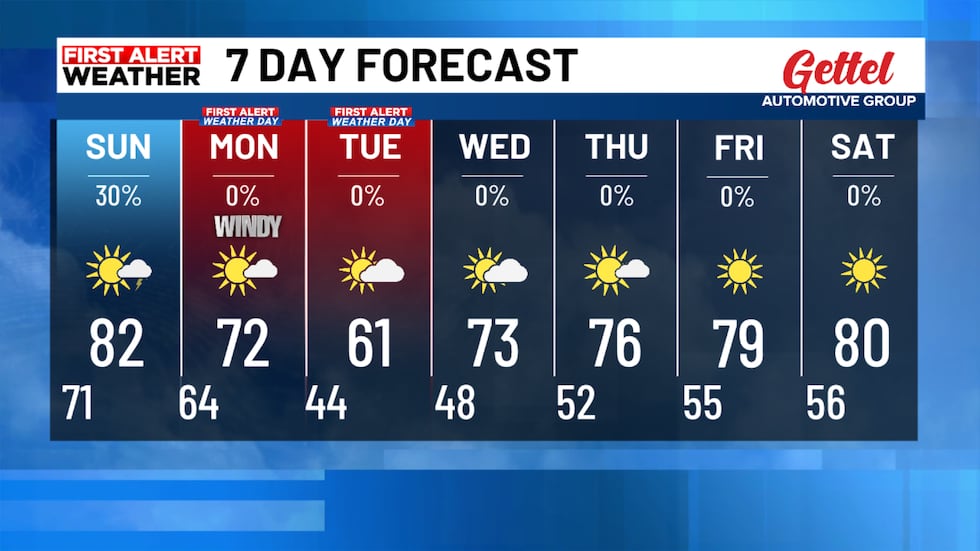 A chill couple of days in the 7 day forecast!(WWSB)Bottom Line
Warmth now, cooling fast later. A few sprinkles Sunday, then a sharp wind and temperature shift Monday night into Tuesday. Jackets and beach chairs might both be useful this week, but maybe not at the same time.
Copyright 2025 WWSB. All rights reserved.