
Strong storms move across Central Florida ahead of winter blast | See timing
RUINED, ANYBODY’S AFTERNOON PLANS COULD BE RUINED BECAUSE OF SEVERE WEATHER. IT’S GOING TO BE ONE OF THOSE. YOU KNOW, I’VE HAD A FEW PEOPLE ASKING ON FACEBOOK AND ON TWITTER KIND OF HOW ARE MY PLANS FOR THIS OR HOW ARE MY PLANS FOR THAT? IT’S GOING TO GET STORMY THIS AFTERNOON. IT’S NOT GOING TO STORM ON ALL OF US, BUT IT’S DEFINITELY SOMETHING THAT WE HAVE TO KIND OF EYEBALL HERE THROUGH THE DAY. WESH TWO MOBILE APP WILL TIME IT ALL OUT FOR YOU. IT WILL SEND YOU NOTIFICATIONS, BUT I WILL ALSO MENTION ALL OF THESE STORMS ARE BECAUSE WE HAVE A COLD FRONT MOVING IN. AND NOT ONLY IS IT USHERING IN THE COLDEST AIR CENTRAL FLORIDA HAS SEEN SINCE FEBRUARY, BUT IN LOOKING AT EARLY NOVEMBER, IT’S THE COLDEST AIR WE HAVE SEEN SINCE 1993. YEAH, IT’S BEEN A MINUTE SINCE WE’VE BEEN THIS COLD THIS EARLY IN THE SEASON. THERE’S THE FRONT NOW. IT’S ALREADY DEVELOPING MOISTURE OUT OVER THE GULF, AND WE HAVE SOME STORMS IN OUR AREA ALREADY. 10 A.M. FUTURECAST SHOWING SOME RAIN FOR SUMTER, MARION, LAKE COUNTIES. THAT CONTINUES THROUGH LUNCHTIME. BUT THEN AFTER LUNCHTIME, THAT’S WHEN THE COVERAGE INCREASES AS DAYTIME TEMPERATURES PUSH INTO THE MID 80S. THE ATMOSPHERE WILL FEED THIS AND HELP TO PRODUCE SOME OF THESE THUNDERSTORMS. SO I THINK 2 TO 4 IS REALLY WHEN WE’LL GET THINGS GOING. AND THEN FIVE, SIX, 7:00 THINGS WILL START TO TAPER OFF JUST THEREAFTER. NOW IN TERMS OF THE THREATS FROM THESE STORMS, I’M ANTICIPATING SOME GUSTY WINDS, OBVIOUSLY SOME TORRENTIAL DOWNPOURS, BUT COULD EVEN TAP INTO SOME OF THE COLDER AIR UPSTAIRS IN THE ATMOSPHERE. THUS, HAIL IS A BIT OF A CONCERN, BUT IT SHOULD BE MOVING QUICK ENOUGH THAT WE’RE NOT LOOKING AT A FLOODING CONCERN. AND FRANKLY, THE ATMOSPHERE DOESN’T HAVE A TON OF SPIN. SO FOR NOW, TORNADOES DO NOT LOOK TO BE A BIG WORRY. BUT OUR ENTIRE AREA UNDER A LEVEL ONE OUT OF FIVE RISK FOR ISOLATED, STRONG TO SEVERE STORMS FOR THE DAY. TODAY WE START OFF WITH THE FOG. THEN WE’LL GET SOME SUNSHINE. BUT ONE, TWO, 3:00 IS WHEN WE’LL REALLY START TO GET THOSE SHOWERS DEVELOPING AND THEN THUNDERSTORMS TWO TO ABOUT 6 OR 2 TO ABOUT 7 P.M. OKAY. ALL RIGHT. THAT SAID, FOR TODAY WE’RE TRACKING THE STORMS AHEAD OF THIS COLD FRONT. BUT JUST KNOW THAT AFTER THE FRONT FOR TOMORROW, WE GET A HUGE PUSH OF COLD, DRY AIR. SO WHILE WE’RE WAKING UP TO TEMPERATURES IN THE 70S THIS MORNING, TOMORROW MORNING, IT’S 60 DEGREES IN THE METRO. AND BY TUESDAY MORNING IT’S 38. IN ORLANDO, 35 IN LEESBURG. AND NOW MODELS ARE SAYING WE’LL GET TO OR BELOW FREEZING IN MARION COUNTY. UNDERSTAND ONE THING THOUGH, THE WINDS ARE GOING TO BE GUSTING. SO IT’S NOT LIKE WE’RE GOING TO SEE A MASSIVE FROST EVENT, BUT WE’RE DEFINITELY GOING TO SEE THESE CHILLY TEMPERATURES THIS MORNING. WE’RE ALSO WATCHING THE FOG 71 DEGREES IN DAYTONA BEACH. VISIBILITY IS DROPPING THEIR FOG AS WELL OUT WEST, AND DENSE FOG ADVISORIES IN EFFECT OUT WEST. WATCHING SOME RAINS HERE ALONG I-75 FROM LAKE WEIR BACK OVER TO LEESBURG. NOT REALLY WATCHING THUNDER AND LIGHTNING IN THERE, BUT IT IS RAIN TO TRACK THIS AFTERNOON. IMPACT WEATHER FOR THE STORMS, THEN CLEARING OUT FOR TOMORROW AND TURNING FRIGID ON TUESDAY. IMPACT WEATHER FOR THE CHILL AND THEN AFTERWARD
Strong storms move across Central Florida ahead of winter blast | See timing

Updated: 10:34 AM EST Nov 9, 2025
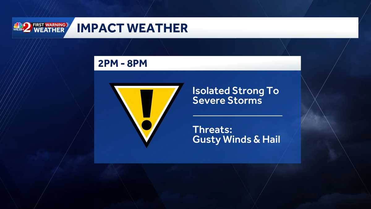
Strong storms are moving across Central Florida on Sunday ahead of a cold front that will send temperatures into the 30s this week ahead. >> RadarThe strongest of storms are expected between 2-8 p.m. The First Warning Weather team is calling for Impact Weather during that time. AlertsNone at this timeCold blast After, temps get COLD — the coldest since February. This is abnormal for November, and temps will rival records, Meteorologist Eric Burris says. Morning temperatures on Tuesday will be in the 30s across Central Florida, with feels-like temps in the upper 20s in some places. Looking aheadFirst Warning Weather Stay with WESH 2 online and on-air for the most accurate Central Florida weather forecast.RadarSevere Weather AlertsDownload the WESH 2 News app to get the most up-to-date weather alerts. The First Warning Weather team includes First Warning Chief Meteorologist Tony Mainolfi, Eric Burris, Marquise Meda and Cam Tran.What is Impact Weather?Impact Weather suggests weather conditions could be disruptive or a nuisance for travel and day-to-day activities.
ORLANDO, Fla. —
Strong storms are moving across Central Florida on Sunday ahead of a cold front that will send temperatures into the 30s this week ahead.
>> Radar
The strongest of storms are expected between 2-8 p.m. The First Warning Weather team is calling for Impact Weather during that time.
This content is imported from Twitter.
You may be able to find the same content in another format, or you may be able to find more information, at their web site.
Alerts
Cold blast
After, temps get COLD — the coldest since February. This is abnormal for November, and temps will rival records, Meteorologist Eric Burris says.
Morning temperatures on Tuesday will be in the 30s across Central Florida, with feels-like temps in the upper 20s in some places.
This content is imported from Twitter.
You may be able to find the same content in another format, or you may be able to find more information, at their web site.
This content is imported from Twitter.
You may be able to find the same content in another format, or you may be able to find more information, at their web site.
Looking ahead
This content is imported from Twitter.
You may be able to find the same content in another format, or you may be able to find more information, at their web site.
First Warning Weather
Stay with WESH 2 online and on-air for the most accurate Central Florida weather forecast.
Download the WESH 2 News app to get the most up-to-date weather alerts.
The First Warning Weather team includes First Warning Chief Meteorologist Tony Mainolfi, Eric Burris, Marquise Meda and Cam Tran.
What is Impact Weather?
Impact Weather suggests weather conditions could be disruptive or a nuisance for travel and day-to-day activities.