
Impact Weather With Stronger Storms In Central Florida Tonight Followed By the Coolest Air of the Season Tuesday
Impact Weather With Stronger Storms In Central Florida Tonight Followed By the Coolest Air of the Season Tuesday
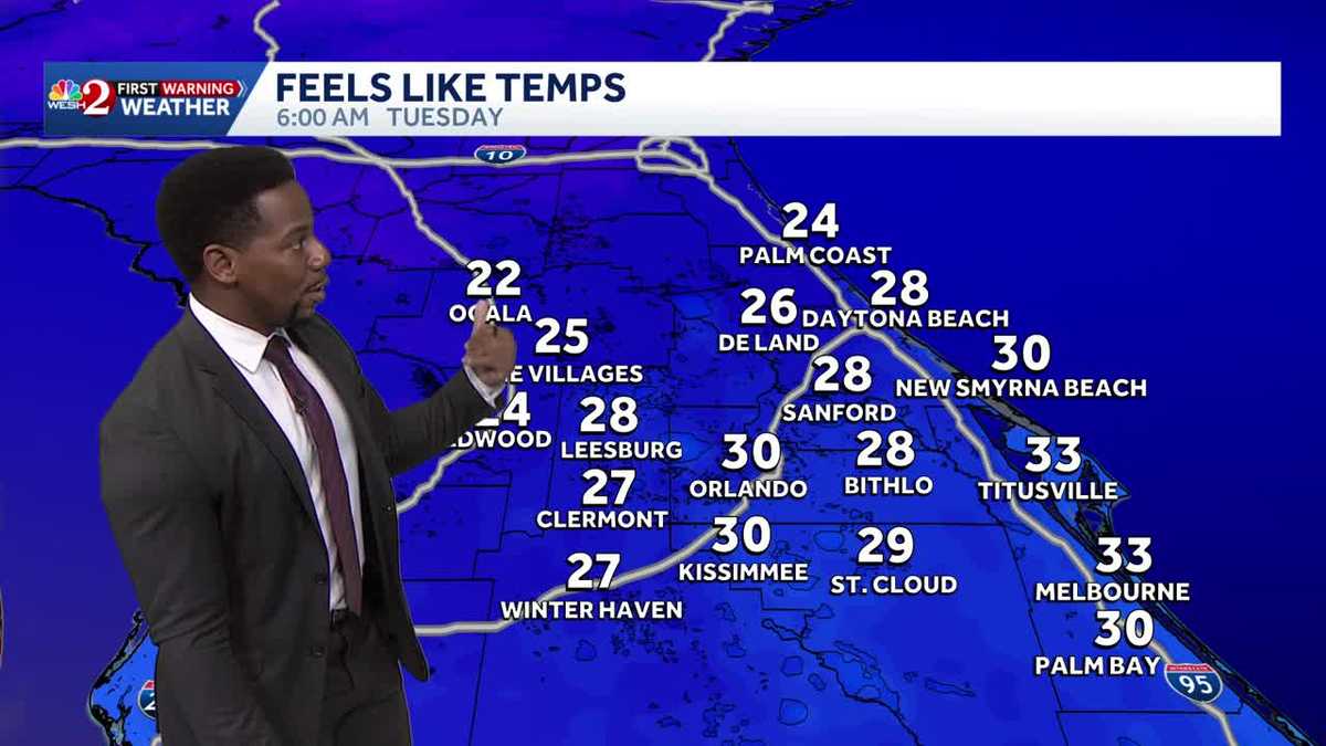
SCRUBBED IS BECAUSE OF THE IMPACT WEATHER WE ARE EXPERIENCING TODAY. ARE WE STILL DEALING WITH RAIN OUT THERE? YEAH, WE WILL BE FOR THE NEXT HOUR, HOUR AND A HALF IF YOU’RE ALONG THE COAST. BUT THESE RAIN SHOWERS, THEY’RE COMING IN WAVES, RIGHT? WE’VE GOT RAIN AHEAD OF A COLD FRONT MOVING IN. HERE’S A LOOK AT THE PICTURE. YOU SEE THE SHOWERS ACROSS CENTRAL FLORIDA, BUT YOU SEE SOME SHOWERS JUST BEHIND THE FRONT ITSELF WHERE WE DO HAVE SEVERE THUNDERSTORMS ON THE FLORIDA GEORGIA LINE FURTHER UP TOWARDS THE NORTH. AND THAT’S WHAT’S GOING TO BE MAKING ITS WAY CLOSER TO US OVER THE COURSE OF YOUR OVERNIGHT HOURS. SO WE CAN HAVE ANOTHER BATCH OF SHOWERS HEADING OUR DIRECTION. LET’S TALK ABOUT THE HERE AND NOW THOUGH, ACROSS THE I-95 CORRIDOR, YOU SEE THE HUNDREDS OF LIGHTNING STRIKES OFFSHORE AND SOME OF THEM STILL ON LAND RIGHT NOW, IN WHICH WE’RE STILL WATCHING OUT FOR THIS SEABREEZE COLLISION. NOW, THE GENERAL MOVEMENT OF THESE SHOWERS AND STORMS IS FROM THE SOUTHWEST TO THE NORTH AND THE EAST. BUT WHAT IT’S COLLIDING WITH IS THAT SEA BREEZE COMING IN FROM THE EAST AS WELL. SO THAT’S ONLY INCREASING THE INSTABILITY. HENCE THE REASON WHY WE SEE THOSE STRONGER STORMS ACROSS OUR COASTLINE IN AREAS LIKE TITUSVILLE, MIMS, PORT, SAINT JOHN, ACROSS THE KENNEDY PARKWAY AS WELL. YOU GUYS ARE WATCHING THE SHOWERS COME DOWN AT A MODERATE RATE. THANKFULLY, THESE SHOWERS AND STORMS ARE MOVING A LITTLE BIT FASTER THAN THE ONES THAT WE’VE SEEN OVER THE COURSE OF THE LAST FEW WEEKENDS. THEREFORE, IF THE RAIN IS OVERHEAD, IT’S NOT GOING TO LAST FOREVER DUE TO THE FAST MOVING NATURE OF THESE SHOWERS AND STORMS. LOOKS LIKE ALONG TOLL 528 WE’RE STILL WATCHING THE SHOWERS COMING IN FROM THE SOUTH AND THE WEST AS WELL. WE’LL ZOOM IN NICE AND TIGHT HERE ACROSS STATE HIGHWAY 520 NOAA ROAD. YOU GUYS SEE MODERATE RAIN AS WELL. FURTHER OFF TOWARDS THE SOUTH. WE’RE STILL WATCHING THE SHOWERS IN PARTS OF OSCEOLA COUNTY, BUT BACK TOWARDS MELBOURNE. THIS IS A NEW BATCH OF RAIN THAT IS DIRECTLY OVERHEAD RIGHT NOW. LET’S GO OUTSIDE IN MELBOURNE WHERE TEMPERATURES STILL SHOW 80 DEGREES. AS WE WERE TRENDING WARM THIS SUNDAY, MOST OF US ARE BACK IN THE MID IN THE LOWER 70S NOW, AS THE SUN IS OFFICIALLY SET, BUT 80 ON THE DOT FOR MELBOURNE. TITUSVILLE. THIS IS WHERE WE GOT. WE SAW THE MOST SIGNIFICANT RAIN ALREADY TODAY. THREE INCHES OF VITO 1.96 TO 1.95. BLACK HAMMOCK SCOTTSMOOR STILL ABOVE OR RIGHT AROUND AN INCH AND A HALF. I MENTIONED THAT WE’LL SEE THESE SHOWERS ALONG OUR COASTAL COMMUNITIES PUSH OFFSHORE JUST BY 8:00. AND WHAT WE’RE GOING TO BE LEFT WITH BREEZY CONDITIONS OVERNIGHT. AND HERE COMES A NEW ROUND OF RAIN SLIDING IN FROM THE GULF COAST, IN WHICH OVERNIGHT WE COULD SEE THE RAIN IN LEESBURG PLACES LIKE DELAND, DAYTONA BEACH AS WELL. NOT AS STRONG AS WE HAVE SEEN SO FAR THIS AFTERNOON, BUT ONCE THE RAIN FINALLY COMES TO AN END OUT THE DOOR ON MONDAY MORNING, WE’RE BREEZY, RIGHT? THESE ARE YOUR SUSTAINED WINDS OR GUSTS, EXCUSE ME, IN WHICH WE COULD POSSIBLY SEE GUSTS ANYWHERE BETWEEN 20 AND 25MPH UNDER CLEAR SKIES TOMORROW. SO THE SUNSHINE IS GOING TO BE BACK. IT WILL BE COOLER AND IT WILL BE BREEZY OUTDOORS. TOMORROW WE’RE GOING TO HOLD ON TO IMPACT WEATHER FOR THE NEXT HOUR HERE IN CENTRAL FLORIDA, AND THEN WE’LL SEE THE SHOWERS AND STORMS TAPER OFF SHORE. ULTIMATELY, THOUGH, MONDAY AND TUESDAY ARE GOING TO BE SOME OF THE COOLEST DAYS THAT WE’VE HAD SO FAR THROUGHOUT THE FALL SEASON. HIGH PRESSURE IS GOING TO DOMINATE OUR FORECAST, WHICH MEANS SUNSHINE IS GOING TO BE BACK. BUT UNDER THESE COOL TEMPERATURES WILL DROP INTO THE 30S AND 40S OUT THE DOOR ON TUESDAY MORNING. THEREFORE, WE DO HAVE A FREEZE WATCH IN PLACE FOR THE WESTERN HALF OF MARION COUNTY, AS TEMPERATURES HERE COULD BE DROPPING AS LOW AS 30 DEGREES. RECORD SETTING NUMBERS IN OCALA, YOU’LL BE COMING CLOSE TO A RECORD, ACTUALLY LIKELY BREAKING A RECORD IN ORLANDO, AND YOU’LL BE BREAKING RECORDS IN PLACES LIKE SANFORD AND LEESBURG. AS THE COOL AIR IS GOING TO BE FELT EVERYWHERE. BUT ONCE YOU FACTOR IN THE WIND CHILL, LOOK HOW LOW THE NUMBERS DROP IN PLACE ALONG I-75. OCALA, THE VILLAGES, WILDWOOD, ALL BACK IN THE 20S. TO START OFF YOUR TUESDAY MORNING AS FAR AS FEELS LIKE TEMPERATURES GO, THAT WIND CHILL FACTOR. SO MAKE SURE YOU GOT THE WINTER ATTIRE IF YOU HAVEN’T GRABBED IT OUT OF THE ATTIC QUITE YET, YOU’LL NEED IT ON TUESDAY AND WEDNESDAY. IMPACT WEATHER ON TUESDAY. DUE TO THE COOL NATURE OF OUR TEMPERATURES.
Impact Weather With Stronger Storms In Central Florida Tonight Followed By the Coolest Air of the Season Tuesday
Impact Weather With Stronger Storms In Central Florida Tonight Followed By the Coolest Air of the Season Tuesday

Updated: 7:33 PM EST Nov 9, 2025
Impact Weather With Stronger Storms In Central Florida Tonight Followed By the Coolest Air of the Season TuesdayImpact Weather this afternoon and early evening as a Marginal Risk (1/5) for severe weather is in place across Central Florida today, meaning a few storms could turn strong /severe this afternoon and evening. The main threats will be gusty winds up to 60 mph, frequent lightning, and hail, especially from the metro on towards the coast. A cold front is moving into a warm and unstable environment, and as it pairs with a sea breeze, we could possibly see some stronger storms towards the shoreline. Once those storms move offshore tonight, a strong cold front will sweep through the area, bringing in drastic shift to our temperatures. Behind the front, expect much cooler and breezy conditions to start the week. Morning wind chills could drop into the 20s/30s, some of the coldest readings we’ve seen so far this season. Boaters should also be aware of rough seas and increasing northerly winds, with a Small Craft Advisory taking effect Monday. Temperatures will struggle to reach the 60s and 70s Monday, falling into the 30s and 40s overnight, so make sure to have your winter attire ready.
Impact Weather With Stronger Storms In Central Florida Tonight Followed By the Coolest Air of the Season Tuesday
Impact Weather this afternoon and early evening as a Marginal Risk (1/5) for severe weather is in place across Central Florida today, meaning a few storms could turn strong /severe this afternoon and evening. The main threats will be gusty winds up to 60 mph, frequent lightning, and hail, especially from the metro on towards the coast. A cold front is moving into a warm and unstable environment, and as it pairs with a sea breeze, we could possibly see some stronger storms towards the shoreline. Once those storms move offshore tonight, a strong cold front will sweep through the area, bringing in drastic shift to our temperatures. Behind the front, expect much cooler and breezy conditions to start the week. Morning wind chills could drop into the 20s/30s, some of the coldest readings we’ve seen so far this season. Boaters should also be aware of rough seas and increasing northerly winds, with a Small Craft Advisory taking effect Monday. Temperatures will struggle to reach the 60s and 70s Monday, falling into the 30s and 40s overnight, so make sure to have your winter attire ready.