
Impact Weather: Arctic blast to brings temps down to low 30s in parts of Central Florida
FIRST WARNING METEOROLOGIST ERIC BURRIS. WAKING UP STILL COMFORTABLE THIS MORNING, BUT BIG CHANGE COME TOMORROW MORNING. BIG CHANGE. ALL RIGHT, SO LET’S TALK ABOUT THIS. IT’S NOT ONLY GOING TO BE THE COLDEST AIR WE’VE SEEN IN A LONG WHILE, BUT THIS IS SUPER EARLY TO GET THIS COLD. SO I WENT INTO THE RECORD BOOKS. ALL RIGHT. WE’RE GOING FULL ON NERD HERE. IT WAS 1993. SINCE WE GOT THIS COLD THIS EARLY. AND BY THE WAY, IN RECORDED HISTORY, THAT’S THE ONLY TIME THAT WE HAVE EVER GOTTEN TO 37 DEGREES THROUGH TOMORROW’S DATE. THE 11TH OF THE 11TH MONTH. SO KIND OF AN INTERESTING LITTLE TIDBIT. TOMORROW MORNING, I’M EXPECTING ALMOST EVERY CENTRAL FLORIDA LOCATION TO SHATTER AN OLD RECORD. OCALA 30 DEGREES IS THE FORECAST. 31 IS YOUR UNOFFICIAL RECORD. THE REST OF THESE ARE OFFICIAL RECORDS. 35 IN LEESBURG. THE OLD ONE IS 38. I MEAN, WOW, 35 IN SANFORD, 36 IN DAYTONA BEACH. I THINK YOU’RE GOING TO BE THE ONLY LOCATION THAT DOES NOT SHATTER A RECORD. ORLANDO RECORD LOW FOR THIS DATE IS 39, WILL HIT 37 DEGREES, AND EVEN MELBOURNE WILL BE LOOKING TO ABOUT 41 DEGREES. SO LET ME SHOW YOU WHAT TO EXPECT TOMORROW MORNING, BECAUSE THIS IS GOING TO BE A SHOCK TO THE SYSTEM. 37 IN ORLANDO, 34 IN APOPKA, 35 DEGREES IN WINDERMERE AND 35 DEGREES FROM CHRISTMAS. BACK OVER TO WEDGEFIELD. LOOK UP TO THE NORTH. 34 IN DELTONA, 34 DEGREES IN DELAND, 3637 DEGREES FROM DAYTONA BEACH OVER TO EDGEWATER. OAK HILL, BUT THIS IS GOING TO BE THE AREA OF COLDEST AIR. NOW, TO GIVE YOU AN IDEA WHAT THESE COLORS ARE, THE LIGHTER BLUE. THAT’S AREAS THAT COULD SEE FROST. THESE DEEPER BLUES. THAT’S AREAS THAT COULD SEE FREEZING TEMPERATURES 30 DEGREES IN OCALA, YOU’LL SEE THE FIRST FREEZE OF THE YEAR. 33 LAKE PANASOFFKEE 35, IN LEESBURG, 34 ASTATULA 36 FOR US IN CLERMONT, 37 IN SAINT CLOUD. AND NOTICE OUT ON THE BARRIER ISLAND WILL BE INTO THE LOWER 40S. WE HEAD INLAND JUST A LITTLE BIT AND IT’S THE UPPER RANGE OF THE 30S. THEN WE BRING IN THE WINDS. OKAY. AND THIS IS HOW IT ACTUALLY FEELS. TOMORROW MORNING, EVEN COLDER, 28 DEGREES IS THE FEELS LIKE TEMPERATURE. TOMORROW MORNING IN ORLANDO, 25 IN DELAND 23 DEGREES IN OCALA. MODEL RUN AFTER MODEL RUN. HAS CONSISTENTLY MADE THIS COLDER. SO ABSOLUTELY WE ARE HAVING TO CALL THIS IMPACT WEATHER BECAUSE THE WINDS THIS AFTERNOON ARE GUSTING TO 2025. SAME THING FOR TOMORROW MORNING. THAT’S IMPACTFUL MY FRIENDS. SO JUST KNOW THIS. IT’S NOT ONLY GOING TO BE THE COLDEST IN ORLANDO IN YEARS. IT’S BEEN SINCE 2023 THAT WE’VE GOTTEN THIS COLD IN ORLANDO ALL SEASON LONG. AND WE’RE GOING TO DO IT IN LIKE MID NOVEMBER. JACKET WEATHER. ABSOLUTELY. TOMORROW MORNING THIS MORNING, STARTING OFF, MILD TEMPERATURES ARE DROPPING THROUGH ABOUT 7 A.M. THEN WE’LL CLIMB UP THROUGH THE DAY. THE SUN WILL HELP US RIGHT THEN. ONCE THE SUN SETS TONIGHT, THOSE TEMPERATURES ARE GOING TO PLUMMET AS THIS CHILLY AIR JUST SITS IN PLAY. AND GIVEN THE POSITION OF THIS AREA OF HIGH PRESSURE, WE BASICALLY STAY COOL THE NEXT COUPLE OF DAYS. IT’S NOT UNTIL ABOUT THURSDAY, FRIDAY, SATURDAY THAT TEMPERATURES REALLY REBOUND MUCH. DAYTONA BEACH GOOD MORNING TO YOU. WAKING UP TO TEMPERATURES IN THE 60S, WE’RE RIGHT AT 70 DEGREES IN ORLANDO AND THERE’S A FEW SHOWERS EXITING BREVARD COUNTY. THAT’S THE LAST OF IT. THEN IT’S ALL ABOUT THE COOL DRY AIR MOVING IN. IMPACT WEATHER TOMORROW MORNING. AND NOTICE IT IS A SLOW CLIM
Impact Weather: Arctic blast to brings temps down to low 30s in parts of Central Florida

Updated: 7:33 AM EST Nov 10, 2025
Central Florida is expected to experience the coldest air of the season so far, with the possibility of record-low temperatures.This is the earliest we’ve experienced such a significant drop in temperatures since 1993.Monday night, most of the area is expected to experience temperatures in the 30s, with wind gusts of 15-20 mph, making it feel like the 20s and 30s. Some areas may experience frost, while others could encounter freezing temperatures.Highs on Tuesday are expected to struggle to reach nearly 60 degrees, and temperatures are expected to slowly warm back to normal by the weekend. Almost every location in Central Florida is expected to break an old record on Tuesday. This weather is being described as Impact Weather due to the significant change in conditions. First Warning Weather Stay with WESH 2 online and on-air for the most accurate Central Florida weather forecast.RadarSevere Weather AlertsDownload the WESH 2 News app to get the most up-to-date weather alerts. The First Warning Weather team includes First Warning Chief Meteorologist Tony Mainolfi, Eric Burris, Marquise Meda and Cam Tran.What is Impact Weather?Impact Weather suggests weather conditions could be disruptive or a nuisance for travel and day-to-day activities.What is a Severe Weather Warning Day?A Severe Weather Warning Day suggests weather conditions that could potentially harm life or property.
ORLANDO, Fla. —
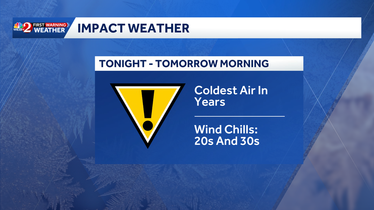
Central Florida is expected to experience the coldest air of the season so far, with the possibility of record-low temperatures.
This is the earliest we’ve experienced such a significant drop in temperatures since 1993.
Monday night, most of the area is expected to experience temperatures in the 30s, with wind gusts of 15-20 mph, making it feel like the 20s and 30s.
This content is imported from Twitter.
You may be able to find the same content in another format, or you may be able to find more information, at their web site.
Some areas may experience frost, while others could encounter freezing temperatures.
Highs on Tuesday are expected to struggle to reach nearly 60 degrees, and temperatures are expected to slowly warm back to normal by the weekend.
Almost every location in Central Florida is expected to break an old record on Tuesday.
This weather is being described as Impact Weather due to the significant change in conditions.
First Warning Weather
Stay with WESH 2 online and on-air for the most accurate Central Florida weather forecast.
Download the WESH 2 News app to get the most up-to-date weather alerts.
The First Warning Weather team includes First Warning Chief Meteorologist Tony Mainolfi, Eric Burris, Marquise Meda and Cam Tran.
What is Impact Weather?
Impact Weather suggests weather conditions could be disruptive or a nuisance for travel and day-to-day activities.
What is a Severe Weather Warning Day?
A Severe Weather Warning Day suggests weather conditions that could potentially harm life or property.