
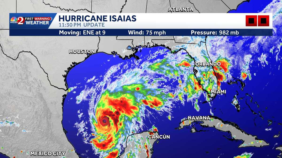

Hurricane Isaias formed in the Gulf late Wednesday, according to the National Hurricane Center.
This content is imported from facebook. You may be able to find the same content in another format, or you may be able to find more information, at their web site.
As of the NHC’s 11 p.m. update Wednesday, Isaias was about 180 miles northwest of Progreso, Mexico, and 460 miles south-southwest of the mouth of the Mississippi River.
The Category 1 hurricane had maximum sustained winds of 75 mph and was moving east-northeast at 9 mph as of 11:30 p.m. Wednesday. Its minimum central pressure was 982 millibars.
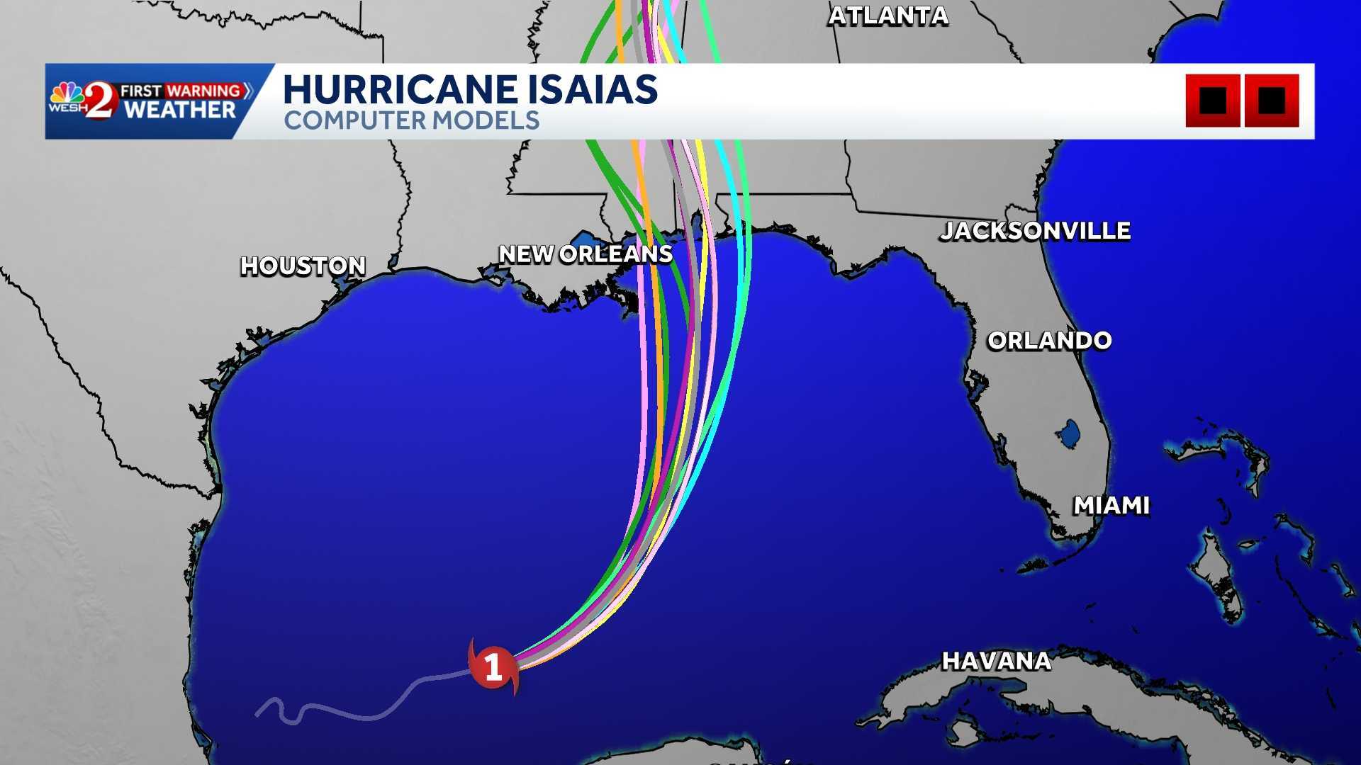
A continued east-northeastward motion is expected Wednesday night, followed by a turn toward the northeast and north on Thursday and Friday, according to the NHC.
WESH 2
Hurricane Isaias 11:30 p.m. Wednesday
On the forecast track, Isaias is expected to pass to the north of the Yucatan Peninsula on Thursday and make landfall along the U.S. northern Gulf Coast within the warning area late Friday or early Saturday, NHC forecasters said.
Isaias is the first hurricane of the 2026 Atlantic season.
Watches and Warnings
The NHC at 11 p.m. Wednesday issued the following watches and warnings along the northern Gulf Coast:
>> Storm Surge Watch: Mouth of the Mississippi River to the Steinhatchee River, FL
>> Hurricane Warning: Ocean Springs, MS to the Bay/Gulf County Line, FL
>> Tropical Storm Warning:
Jefferson/Plaquemines Parish Line, LA to west of Ocean Springs, MSEast of Bay/Gulf County Line to Aucilla River, FL
>>Storm Surge Watch: Steinhatchee River to Yankeetown, FL
Will Hurricane Isaias impact Central Florida?
First Warning Meteorologist Cam Tran said Central Florida is not expected to see any direct impacts, but the storm is pulling plenty of moisture into the area, keeping rain chances high.
Hazards Affecting Land
Storm surge: The combination of a dangerous storm surge and the tide will cause normally dry areas near the coast to be flooded by rising waters moving inland from the shoreline. The water could reach the following heights above ground somewhere in the indicated areas if the peak surge occurs at the time of high tide:
Ocean Springs, MS to Indian Pass, FL…5-7 ftMobile Bay…5-7 ftMouth of the Mississippi River, LA to Ocean Springs, MS…3-5 ftIndian Pass, FL to Steinhatchee River, FL…4-6 ftSteinhatchee River, FL to Yankeetown, FL…2-4 ftLake Pontchartrain…1-3 ft
The deepest water will occur along the immediate coast near and to the east of the landfall location, where the surge will be accompanied by large and dangerous waves. Surge-related flooding depends on the relative timing of the surge and the tidal cycle, and can vary greatly over short distances.
Wind: Hurricane conditions are expected within the Hurricane Warning area Friday night into early Saturday, with tropical storm conditions beginning on Friday. Tropical storm conditions are expected in the warning areas on Friday and Friday night. Gusty winds are possible in portions of the Yucatan Peninsula on Thursday.
Rainfall: Isaias is expected to produce rainfall amounts of 1 to 3 inches through Thursday across coastal portions of the eastern Bay of Campeche with isolated higher amounts possible in the states of Campeche and western Yucatan.
From Friday through the weekend, the system is expected to produce rainfall amounts of 3 to 7 inches, with localized totals up to 10 inches, across the central U.S. Gulf Coast extending from far southeastern Louisiana to the Florida Panhandle. Rainfall amounts of 1 to 3 inches, with localized amounts up to 5 inches, are possible across much of the Southeast as far north as the Tennessee Valley and the Carolinas. Flash and urban flooding, along with isolated river flooding, will be possible.
Tornadoes: Isolated tornadoes will be possible Friday night in coastal areas of Alabama and the Florida Panhandle. The tornado threat will persist into Saturday for eastern Alabama, western Georgia and the Florida Panhandle.
Surf: Swells will affect the western and northern portions of the Yucatan Peninsula beginning on Thursday and spread northward toward the Gulf Coast late this week. These swells are likely to cause life-threatening surf and rip current conditions. Please consult products from your local weather office.
RESOURCES | HURRICANE SEASON SPECIAL | WESH LONG-RANGE FORECAST | WHAT TO KNOW ABOUT INSURANCE | GENERATOR SETUP | TESTING CHAINSAWS | POST-STORM RESOURCES | DOWNLOAD WESH 2 APP | HURRICANE SUPPLIES | SURVIVAL GUIDE
Tracking the Tropics
Stay with WESH 2 online and on-air for the most accurate Central Florida weather forecast.
Download the WESH 2 News app to get the most up-to-date weather alerts.
The First Warning Weather team includes First Warning Chief Meteorologist Tony Mainolfi, Eric Burris, Cam Tran, Victoria Wisniewski and Luke Vickery.
>> 2026 hurricane season | WESH long-range forecast
>> Download Very Local | Stream Central Florida news and weather from WESH 2