
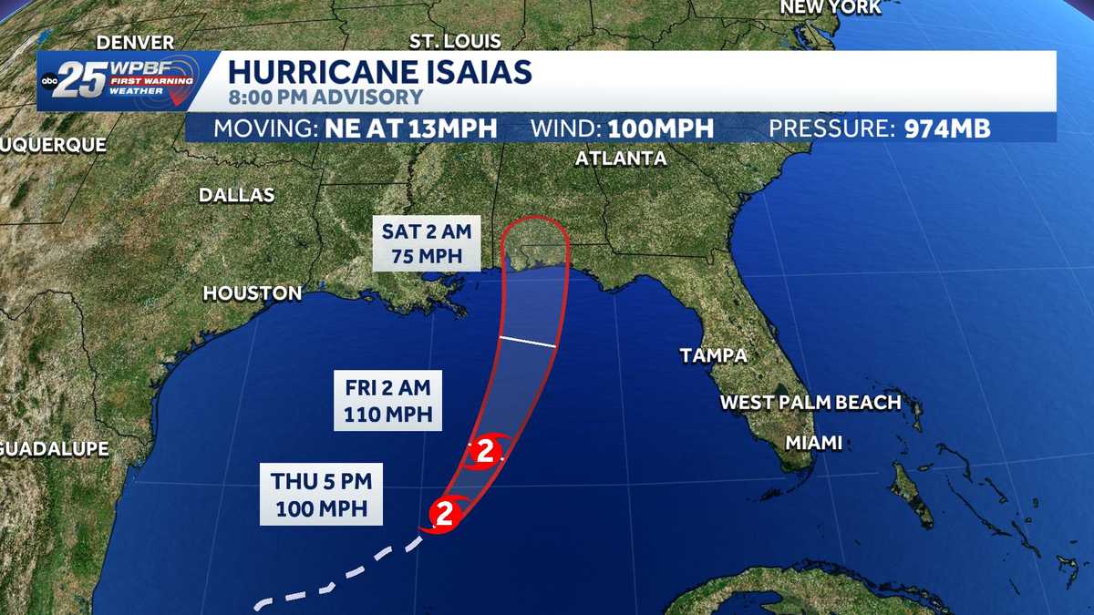

Isaias became the first hurricane of the 2026 Atlantic season and is on track to make landfall between the Mississippi coast and the Florida Panhandle late Friday or early Saturday, the National Hurricane Center said.
Related: Hurricane Isaias forecast: Computer models and maps
As of the 8 p.m. advisory, Isaias was located about 255 miles north-northeast of Progreso, Mexico and about 290 miles south of the Mouth of the Mississippi River.
It was moving northeast at 13 mph with 100 mph maximum sustained winds.
Hurricane Isaias is intensifying, according to NOAA Hurricane Hunters, as residents along the Gulf Coast are urged to finalize preparations.
“Preparations to protect life and property from storm surge and damaging winds along the warning area of the Gulf Coast should be rushed to completion today,” NOAA said.
 Tracking Isaias
Systems become Category 1 storms when they reach 74 mph.
The previous eight storms have been tropical.
Isaias became the latest-forming first hurricane on record. That previous record was set by an unnamed 1905 hurricane, which became a hurricane at 8 p.m. EDT on Oct. 7 in the Gulf. This was 60 years before satellites were used to track storms.
Only 1907 and 1914 failed to produce a hurricane.
NHC said there will be a turn toward the northeast and north later Thursday and Friday.
“On the forecast track, Isaias is expected to pass to the north of the Yucatan Peninsula later today and make landfall along the U.S. northern Gulf Coast within the warning area late Friday or early Saturday,” the NHC said.
From Friday through the weekend, the NHC said the hurricane is expected to produce rainfall of 3 to 7 inches, with localized totals up to 10 inches, across the central U.S. Gulf Coast extending from far southeastern Louisiana to the Florida Panhandle.
Rainfall amounts of 1 to 3 inches, with localized amounts up to 5 inches, are possible across much of the Southeast as far north as the Tennessee Valley and the Carolinas, the NHC said. Flash and urban flooding, along with isolated river flooding, will be possible.
Hurricane and storm surge watches and warnings have been issued for portions of the northern Gulf Coast.
Watches and Warnings
Storm Surge Warning
Mouth of the Mississippi River to the Suwannee River
Hurricane Warning
Ocean Springs, MS to the Bay/Gulf County Line, FL
Tropical Storm Warning
Jefferson/Plaquemines Parish Line, LA to west of Ocean Springs, MSEast of Bay/Gulf County Line to Aucilla River, FL
Storm Surge Watch
Suwannee River to Yankeetown
The storm was previously Tropical Depression Nine and Invest 92-L in the southwestern Gulf.
Tracking the Tropics
Stay with WPBF 25 on air and online for updates.
Download the WPBF 25 News app for the most up-to-date weather alerts.